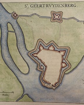
Pays-Bas, Plan de ville - Mont Saint-Laurent; Joan Blaeu - St. Geertruydenberg. - 1649
Nº 83149905

Nº 83149905
Episcopatvs Stavangriæ Pars Avstralis, Antique map of southern Norway Stavanger area, originates from - Atlas Maior, vol 1, map 13 - Joan Blaeu, 1667.
Techniques: Copper-plate Engraving
Date/Place: 1667
Place: Netherlands
Size: 47 cm x 59 cm
Condition: Generally very good with the usual light overall toning, wear, there may be minor imperfections to be expected with age.
We include the Certificate of Authenticity. This Item is professionally protected by handmade packing.
Comment acheter sur Catawiki ?
1. Découvrez des objets d’exception
2. Faites la meilleure offre
3. Effectuez un paiement sécurisé