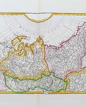
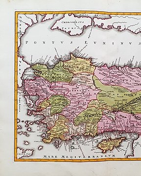
No. 82214489

Sold
Europe, Map - Germany / Lower Saxony / Hanover / Braunschweig; Johann Baptist Homann - Ducatus Brunsuicensis in tres suos Principatus: Calenbergicum, Grubenhag e Guelpherbitanum - 1701-1720
Final bid
€ 37
10 weeks ago

Europe, Map - Germany / Lower Saxony / Hanover / Braunschweig; Johann Baptist Homann - Ducatus Brunsuicensis in tres suos Principatus: Calenbergicum, Grubenhag e Guelpherbitanum - 1701-1720

Questa Mappa Geografica, è un'incisione su rame originale del 1730 (XVIII° Cen) Circa. Trattasi della rara edizione Latina/Tedesca dell'opera di J.B. HOMANN, edita da lui stesso durante il 18° Secolo. La mappa in questione proviene dall'opera dal nome di: "Atlas Novus Terrarum Orbis Imperia: Atlas Novus indicibus instructus oder neuer mit Wort=Registern versehener Atlas........ in Norimberga, 1730." Grande mappa in FOLIO Grande, edita in GERMANIA, con ottima coloritura originale, ampi margini, e geograficamente ben dettagliata in ogni punto. Condizioni: le condizioni sono abbastanza buone (considerando le proprie dimensioni...) come da foto, con la presenza di qualche innocuo difettuccio, quasi invisibile, dovuto al tempo, ed il tutto non ne pregiudica la propria tenuta e bellezza. Le misure complessive della mappa sono: Cm 61 X 55

No. 82214489

Sold
Europe, Map - Germany / Lower Saxony / Hanover / Braunschweig; Johann Baptist Homann - Ducatus Brunsuicensis in tres suos Principatus: Calenbergicum, Grubenhag e Guelpherbitanum - 1701-1720

Europe, Map - Germany / Lower Saxony / Hanover / Braunschweig; Johann Baptist Homann - Ducatus Brunsuicensis in tres suos Principatus: Calenbergicum, Grubenhag e Guelpherbitanum - 1701-1720

Questa Mappa Geografica, è un'incisione su rame originale del 1730 (XVIII° Cen) Circa.

Trattasi della rara edizione Latina/Tedesca dell'opera di J.B. HOMANN, edita da lui stesso durante il 18° Secolo.
La mappa in questione proviene dall'opera dal nome di: "Atlas Novus Terrarum Orbis Imperia: Atlas Novus indicibus instructus oder neuer mit Wort=Registern versehener Atlas........ in Norimberga, 1730."

Grande mappa in FOLIO Grande, edita in GERMANIA, con ottima coloritura originale, ampi margini, e geograficamente ben dettagliata in ogni punto.

Condizioni: le condizioni sono abbastanza buone (considerando le proprie dimensioni...) come da foto, con la presenza di qualche innocuo difettuccio, quasi invisibile, dovuto al tempo, ed il tutto non ne pregiudica la propria tenuta e bellezza.

Le misure complessive della mappa sono: Cm 61 X 55


Set a search alert
Set a search alert to get notified when new matches are available.

This object was featured in


How to buy on Catawiki

Learn more about our Buyer Protection

      1. Discover something special

      Browse through thousands of special objects selected by experts. View the photos, details and estimated value of each special object. 

      2. Place the top bid

      Find something you love and place the top bid. You can follow the auction to the end or let our system do the bidding for you. All you have to do is set a bid for the maximum amount you want to pay. 

      3. Make a secure payment

      Pay for your special object and we’ll keep your payment secure until it arrives safe and sound. We use a trusted payment system to handle all transactions. 

Have something similar to sell?

Whether you're new to online auctions or sell professionally, we can help you earn more for your special objects.

Sell your object