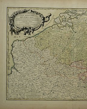
Belgia, Mapa - Luksemburg / Limburgia / Brabancja / Flandria; M. Seutter / T.C. Lotter - Germaniae Inferioris sive Belgii pars Meridionalis - 1757
Nr 83969873

Nr 83969873
16,5 x 21,5 cm.
Kopergravure verschenen in H. de Leth, "Nieuwe Geographische en Historische Atlas, van de Zeven Vereenigde Nederlandsche Provintien", Amsterdam, a.d. 1740.
Oud gekleurd. Vouwen als uitgegeven.
Verzekerde verzending.
Jak kupować w serwisie Catawiki
1. Odkryj coś wyjątkowego
2. Złóż najwyższą ofertę
3. Dokonaj bezpiecznej płatności