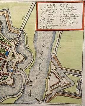
Nederländerna, Stadsplan - Klundert; Marcus Zuerius van Boxhorn - Clundert - 1632
Nr 74607595

Nr 74607595
The map represents England and Wales, divided in counties, with a part of the coast of Ireland and Scotland.This map originally drawn by Cloppenburgh and printed by Pieter van der Keere( Kaerius) for the 1630 edition of the Atlas Minor and is a reduced form of the Hondius/Mercator map in his Atlas Minor.
This last edition of this map was used by Martineau Du Plessis for his book " Nouvelle geographie", published in Paris in 1700.
An attractive map from a rare geography book by Du Plessis nowadays very difficult to find.
Very good condition. Left margin extended with antique paper. Dark print. Folds as published. The map will be shipped folded on the original folds to avoid damage during transport.
Image 18x25,5cm, page 21x28cm
Hur du köper på Catawiki
1. Upptäck något speciellt
2. Lägg det högsta budet
3. Gör en säker betalning