大洋洲, 地图 - 阿森松岛; Th.de Bry - Vera effigies et delineatio Insula Ascenstio - 1601-1620
编号 82755089
编号 82755089
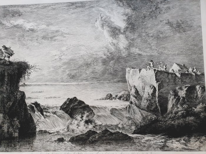
The Rupture of the Dutch Dykes; stormy landscape with water flowing through a breach in a dyke, men standing on either side on top of the dyke and holding their hats against the wind; after Jan Asselyn. 1782
Etching, drypoint and roulette
In the late winter of 1651, stormy weather and tidal surges caused extensive flooding in the Dutch province of North Holland, the areas exposed to the Diemerdijk east of Amsterdam being particularly affected. Finally, on the night of 5–6 March, strong north-westerly winds and a high spring tide caused the Sint Anthonisdijk to rupture in two places, flooding much of the city of Amsterdam. There were numerous eye-witness accounts of the tragedy, and as soon as the waters had subsided sufficiently, artists flooded out of Amsterdam and beyond to record the event.
Inscriptions
Inscription type: inscription
Inscription content: Lettered in lower margin with production details: "J.J. DB 1782" and "Gravé à L'eau forte D'apres un Tableau D'asselin Craesbeke Tiré du Cabinet de Monsieur Tronchin de la Boissiere".
Bibliographic references
Perez 1994 / L'Oeuvre gravé de Jean-Jacques de Boissieu (83)
IFF / Inventaire du Fonds Français: Bibliothèque Nationale, Département des Estampes (83)
Small folds upper right corner.
( British Museum)