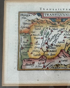
罗马尼亚, 地图 - 特兰西瓦尼亚; A Ortelius / JB Vrients - Transilvania - 1601-1620
编号 84250303
已售出
最终出价
€ 85
2周前
欧洲, 地图 - 波兰; P. Bertius - Imperii Caroli Magni - 1601-1620
This is the upper right part of P. Bertius' 4 sheet wall-map, showing the part of Poland, Croatia, Slavonia, Ukraine and other adjacent states.
P. Bertius, Imperii Caroli Magni.
Amsterdam 1620.
Dimensions: 42,5 x 49 cm (engraving), 46 x 56,5 cm (paper).
Good condition.
编号 84250303
已售出
欧洲, 地图 - 波兰; P. Bertius - Imperii Caroli Magni - 1601-1620
This is the upper right part of P. Bertius' 4 sheet wall-map, showing the part of Poland, Croatia, Slavonia, Ukraine and other adjacent states.
P. Bertius, Imperii Caroli Magni.
Amsterdam 1620.
Dimensions: 42,5 x 49 cm (engraving), 46 x 56,5 cm (paper).
Good condition.
您可能也喜欢
设置搜索提醒
设置搜索提醒,以便在有新匹配项目时随时收到通知。