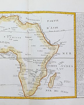
非洲, 地圖 - 奧菲爾; n.n. - De Haven Van Ophir En De Oude Weg Van Tarsis - 約1780年
編號 81774683
已出售
最終出價
€ 60
2 週前
非洲, 地圖 - 維德角; M. Mallet - Isles du Cap-Verd - 1701-1720
Dimensions: 15 x 10.5 cm. (on sheet: 20.5 x 13.5 cm.).
Condition: very good (minor foxing)
Verso:blank
Author: M. Mallet
Publisher: J. A. Jung. Francoforte.
Note: from "Beschreibung des ganzen Welt Kreises"
Alain Mannesson Mallet (1630-1706) was a French mapmaker and engineer who served in the armies of Louis XIV. After rising through the ranks, Mallet was appointed as Inspector of Fortifications, a job which also required mathematical skills and which made him a competent military engineer.
編號 81774683
已出售
非洲, 地圖 - 維德角; M. Mallet - Isles du Cap-Verd - 1701-1720
Dimensions: 15 x 10.5 cm. (on sheet: 20.5 x 13.5 cm.).
Condition: very good (minor foxing)
Verso:blank
Author: M. Mallet
Publisher: J. A. Jung. Francoforte.
Note: from "Beschreibung des ganzen Welt Kreises"
Alain Mannesson Mallet (1630-1706) was a French mapmaker and engineer who served in the armies of Louis XIV. After rising through the ranks, Mallet was appointed as Inspector of Fortifications, a job which also required mathematical skills and which made him a competent military engineer.
您亦可能喜歡
設置搜索提醒
設置搜索提醒,以便在有新匹配可用時收到通知。