We carefully select maps, atlases, views and cartographic works to maintain high-quality and authenticity standards. We only accept authentic object valued at €75 or more. Our experts review every submission to ensure bidders find rare and valuable pieces that appeal to passionate collectors.
Follow these guidelines to increase your chances of a successful sale.
What we accept
We’re looking for authentic, high-quality maps and cartographic objects that appeal to passionate collectors. To be accepted, your object must:
- Fall within our accepted categories:
- Maps
- Atlases
- Prints
- Views (i.e. engravings of a geographical location or city)
- Cartographic objects
- Facsimiles (i.e. a recent accurate copy of an early work), only if they are:
- High-quality, accurate reproductions of important, scarce maps
- Not mass-market reprints or basic modern versions
- Be authentic, scarce and not widely available online (e.g. fewer than 20 copies)
- Be of collectable value and in good condition
- Meet the minimum expected value of €75
(You can combine objects in one submission to meet this threshold)
Tip: While our experts are using rarebookhub.com to compare historical auction records where Catawiki results appear as well, we encourage you to use free reference platforms such as www.maprecord.com or www.oldmaps.com to determine scarcity and retail value.
What increases your chances of approval:
- Fine or scarce maps
- Quality illustrations or engravings
- Early printings or significant geographic changes
- Hand-coloured or lithographed prints
- Comprehensive and accurate geographic information
- Maps, prints, views and atlases produced before 1900
📌 Examples of accepted objects:
World maps from the 16th to the 19th century
Maps depicting a country/an area for the first time
Complete atlases
Old maps issued just before/after country boundaries changes
What we do not accept
To keep our auctions trustworthy and attractive to buyers, we do not accept:
- Common or mass-produced modern atlases (post-1900)
- Tourist maps, folding city guides, or street maps
- Low-quality reprints, or small-scale facsimiles
📌 Examples of rejected objects:
Single facsimile maps
Inconsistent bundles of maps
Getting your submission ready
1. Fill in all the details and write a clear description
When you submit an object, you’ll see fields to guide you in providing the right information, such as: country and geographic region, mapmaker/publisher and title, period and technique (e.g. etching), condition, dimensions (in cm), etc. These fields ensure your listing is clear, searchable, and easy for bidders to understand.
Note: To determine condition, we use the following grading system:
- As new – In the same condition as when it was published. No signs of wear. Only applicable to modern objects (e.g. facsimiles, late 20th/21st-century maps or atlases).
- Fine - Very well preserved. The object may have been opened and handled carefully, but there are no significant defects.
- For maps: Slight traces of wear, only outside the map image.
- For atlases: No damage to the cover, spine, pages or jacket.
- Very good– Shows some small, insignificant signs of wear or age.
- For maps: Minor edge wear, slight spots or handling marks.
- For atlases: Binding or margins may show light wear, but nothing affecting readability or integrity.
- Good– Average used condition.
- For maps: Minor spots, small tears on the edge, or light age-related marks.
- For atlases: All pages present, may show general signs of handling and shelf wear.
- Fair– Noticeable wear or minor damage.
- For maps: Visible creases, staining or edge damage, but the map is complete and legible.
- For atlases: May lack endpapers, half-titles, or show signs of heavy use. Binding or spine may be weakened.
- Poor – Heavily worn or incomplete: missing maps, torn pages, extensive damage, staining, or loose pages. Any missing elements must be clearly noted. Only historically important or rare objects in this state will be accepted.
Please also use the object description field to share:
- Unique features (e.g. signed, limited edition) or notable history of the object
- Background or provenance, additional publication information
- If the object has any flaws
Tip: The more detail you provide, the easier it is for bidders to understand the value of your object – and the more likely it is to sell. Find here more tips on how to write a clear, accurate description.
📌 Examples of a well-written description:
“W. Blaeu - Nova Totius Terrarum Orbis Geographica Ac Hydrographica Tabula - 1630.
Sheet cm 46x58.6. Latin text on verso. An excellent copy perfectly preserved in its original fascinating colouring (with just some very little spots in bottom margin in centre). The title in capitals runs along the upper edge within the map image. The map derives from the 1606/07 wall map today known in one single copy. The geographic content is identical even if because of the smaller size, fewer toponyms are given and the number of legends has also been reduced. Blaeu's world map is framed on all sides by decorative borders. representing on the left the four elements, and on the right the four seasons; on top sun, moon and the five known planets: Mercury, Venus, Mars, Jupiter and Saturn. Along the bottom are seven vignettes showing the seven wonders of the world. A balanced composition and elegant ornamentation make this world map one of the small masterpieces of the seventeenth century.
There are four states of the map: the first state (1606) bears the name Gulielmus Ianssonius. The second adds the signature of the engraver Josua Van den Ende. The third state adds the Strait of Le Maire and the fourth changes to 'Blaeuw' the name of the publisher.
This state was included in Blaeu's 1630 Appendix and in all of the Blaeu family's atlases, except the Atlas maior.
The original 1606 state does not mention an engraver, but from the second state onward the name of Josua van den Ende appears on the map. It is probable that Van den Ende engraved only the geographic content, while someone else was responsible for the decoration”.
2. Great photos matter
Photos are the first thing bidders see – so make them count! We recommend including at least 3 high-quality images that clearly show the condition and details of your object. This helps bidders make informed decisions and increases your chances of a successful sale.
Your photos should include:
For all submissions:
- Front and back of the map or sheet (including edges)
- The cartouche (publisher and title area)
- Close-ups of relevant details, flaws, signatures or stamps
Tip: Avoid photos with people, selfies, or screenshots. Use a neutral background (white or black), avoid low-quality or stock images, and aim for natural lighting. Find here more tips on how to take professional photos.
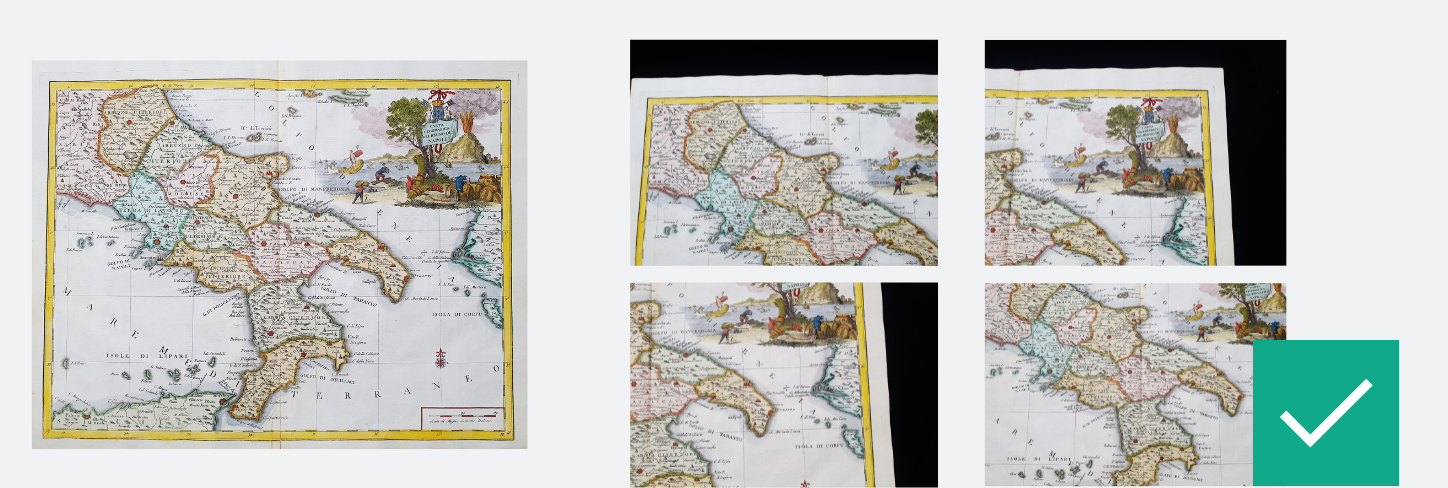
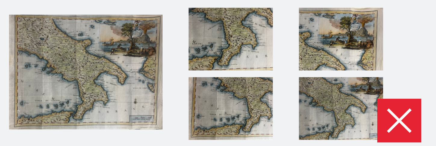
📌 Examples of good vs. bad photos:
- In the first example, the image is bright and shows the entire map, including its edges, making it easy to assess the condition. In contrast, the main image of the second example is dark, cuts off the edges, and makes it difficult for bidders to evaluate the map properly.
3. Additional proof of authenticity
We pay extra attention to ensure authenticity of rare and high-value objects to protect bidders and ensure a trustworthy marketplace.
If your map or atlas is particularly rare or high in value, we may ask for extra verification, such as:
✔ Historical documentation or references
✔ Details of provenance or previous ownership
✔ Comparison with known examples (our experts will assist)
Ready to sell? List your cartographic objects today
Selling with us is free – commission is only applied if your object sells.
Follow these guidelines to maximise your chances of success.
Register as a seller and submit your object for auction now.