N.º 13985215
Vendido
Puja final
€ 371
Hace 341 semanas
Large map of the world in copper. Text in Latin “Nova - Totius - Terrarum - Arbis - Geographica”. AC Hydrographica Tabula. The original was created by Hendrik Hondius in 1641. On the left half, we can see North & South America, New Guinea.

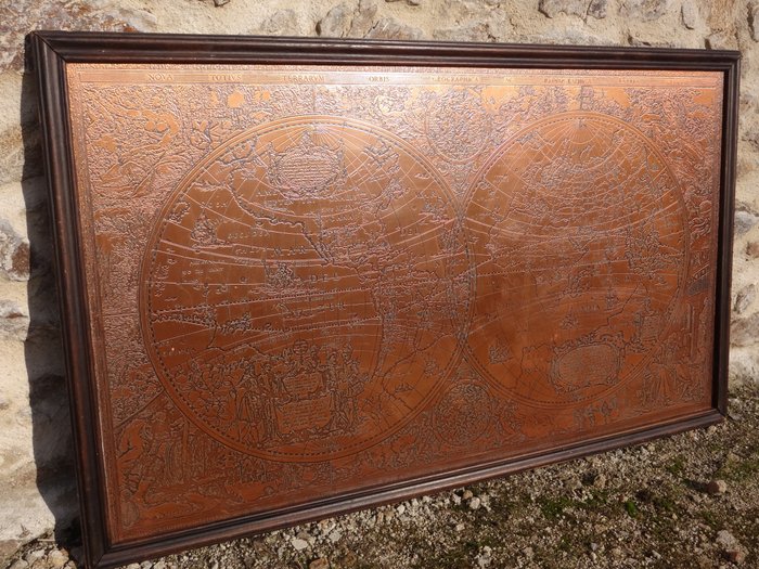
Large map of the world in copper. Text in Latin “Nova - Totius - Terrarum - Arbis - Geographica”. AC Hydrographica Tabula.
The original was created by Hendrik Hondius in 1641.
On the left half, we can see North & South America, New Guinea.
Many figures in the foreground with a text about Christopher Columbus.
On the right we can see Europe, Asia, Africa, China, India...
The sea is decorated with ships from the 17th century and some mythological representations.
Many representations on the sides, decorated with water elements, fire, earth and air, and the four seasons.
The plate is glued on a wooden support
In good condition, slight traces of oxidation, nothing serious, does not alter the State of the object.
Dimensions: 120 cm x 69 cm
Secure shipping with tracking and insurance included (colissimo or mondial relay delivery, depending on country)
Secure shipping with tracking and insurance included (colissimo or mondial relay delivery, depending on country)
Have a good auction!
N.º 13985215
Vendido
Large map of the world in copper. Text in Latin “Nova - Totius - Terrarum - Arbis - Geographica”. AC Hydrographica Tabula. The original was created by Hendrik Hondius in 1641. On the left half, we can see North & South America, New Guinea.
Large map of the world in copper. Text in Latin “Nova - Totius - Terrarum - Arbis - Geographica”. AC Hydrographica Tabula.
The original was created by Hendrik Hondius in 1641.
On the left half, we can see North & South America, New Guinea.
Many figures in the foreground with a text about Christopher Columbus.
On the right we can see Europe, Asia, Africa, China, India...
The sea is decorated with ships from the 17th century and some mythological representations.
Many representations on the sides, decorated with water elements, fire, earth and air, and the four seasons.
The plate is glued on a wooden support
In good condition, slight traces of oxidation, nothing serious, does not alter the State of the object.
Dimensions: 120 cm x 69 cm
Secure shipping with tracking and insurance included (colissimo or mondial relay delivery, depending on country)
Secure shipping with tracking and insurance included (colissimo or mondial relay delivery, depending on country)
Have a good auction!
Configura una alerta de búsqueda
Configura una alerta de búsqueda para recibir notificaciones cuando haya nuevas coincidencias disponibles.
Este objeto apareció en
Cómo comprar en Catawiki
1. Descubre algo especial
2. Haz la puja más alta
3. Paga de manera segura