Italy - Italy; Abraham Ortelius (1527–1598) - Gallia Cisalpina fino alla Sicilia, comprendendo Corsica, Sardegna, Dalmazia, Illirico - 1621-1650


11
days
06
hours
01
minute
59
seconds
Current bid
€ 150
Reserve price not met

Expert
Selected by Volker Riepenhausen
Specialist in travel literature and pre-1600 rare prints with 28 years experience.
Estimate € 300 - € 800
38 other people are watching this object
 Bidder 1105 Bidder 1105 | €150 | |
|---|---|---|
| Bidder 2278 | €125 | |
| Bidder 4576 | €100 |
Catawiki Buyer Protection
Your payment’s safe with us until you receive your object.View details
Trustpilot 4.4 | 123878 reviews
Rated Excellent on Trustpilot.
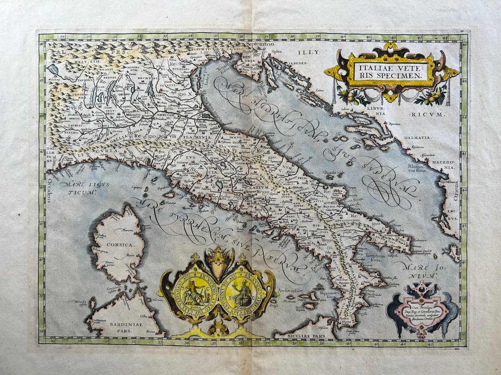
Historical map of Italia Vetus titled Gallia Cisalpina fino alla Sicilia, including Corsica, Sardinia, Dalmatia and Illyricum, by Abraham Ortelius in Theatrum Orbis Terrarum, copper-engraved and hand coloured, 465 × 340 mm, in good condition.
AI-assisted summary
Description from the seller
Historical map depicting ancient Italy (Italia vetus) according to the Roman classical geographic tradition, engraved based on a design by Abraham Ortelius and published within the famous Theatrum Orbis Terrarum, considered the first modern atlas in history.
The map depicts the Italian peninsula from Gallia Cisalpina to Sicily, including Corsica, Sardinia, Dalmatians, Illyricum, and part of Western Greece. The toponymy is entirely in Latin, indicating regions, Roman cities, rivers, promontories, and mountain ranges according to classical sources.
The sea is rendered with elegant dotted hatch typical of Ortelius's engravings. The two large figurative cartouches are particularly decorative.
The title of Ancient Italy, framed by vegetal garlands;
The privilege banner with the inscription 'Cum Privilegio Imp. Reg. et Cancellariae Brabantiae decennali, evulgabat Abrahamus Ortelius,' which certifies the exclusive rights to print.
Additionally, there are allegorical medallions featuring personifications of Italy and Rome, a high-level iconographic element that makes the card particularly sought after.
The input is a dash character, which does not require translation.
Atlante
From Theatrum Orbis Terrarum by Abraham Ortelius, published in Antwerp starting from 1570, in successive editions and languages.
The input is a dash character, which does not require translation.
Condition
Good overall condition. Solid card with visible margins, well-preserved antique coloration.
There are central editorial folds (as in the atlas origin) and slight browning/oxidation at the margins compatible with the age. No invasive restorations are visible from the images.
Details
Era
1400-1900
Number of items
1
Country
Italy
Geographical specification
Italy
Map maker/ publisher
Abraham Ortelius (1527–1598)
Map/ Book title
Gallia Cisalpina fino alla Sicilia, comprendendo Corsica, Sardegna, Dalmazia, Illirico
Period
1621-1650
Condition
Good
Technique
Copper engraving
Additional Information
Theatrum Orbis Terrarum
Map colour
Later hand colour
Height
465 mm
Width
340 mm
Sold by
