Africa - Africa; Robert De Vaugondy par Delamarche - L’Afrique divisée en ses empires, royaumes et républiques - 1751-1760


01
day
16
hours
07
minutes
39
seconds
Current bid
€ 750
Reserve price not met

Expert
Selected by Ilaria Colombo
Specialist in old books, specialising in theological disputes since 1999.
Estimate € 1,700 - € 2,500
24 other people are watching this object
 Bidder 9035 Bidder 9035 | €750 | |
|---|---|---|
| Bidder 9035 | €450 | |
| Bidder 9035 | €250 | |
Catawiki Buyer Protection
Your payment’s safe with us until you receive your object.View details
Trustpilot 4.4 | 121798 reviews
Rated Excellent on Trustpilot.
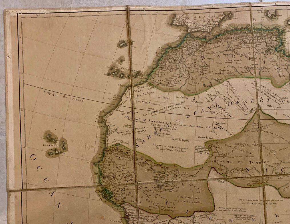
Antique wall map of Africa titled The Africa divided into its empires, kingdoms and republics, copperplate engraving by Robert De Vaugondy published by C. F. Delamarche, Africa, hand-coloured later, mounted on canvas in 15 panels, 100 cm by 117 cm, in good condition.
AI-assisted summary
Description from the seller
Large ancient geographical map of Africa divided into its empires, kingdoms, and republics by S. Robert de Vaugondy, geographer in Paris, at C. F.. Delamarche geographer.
The map depicts the African continent around 1756, reflecting the knowledge of the time; the lakes and rivers appear to be perfectly accurate.
Authentic vintage workshop montage in 15 sections, mounted on canvas and folded, forming a 100cm x 117cm 'portable mural atlas,' much rarer than the 'book' format. All carefully crafted and kept in good condition.
Beautiful and authentic antique wall map of Africa, created by Didier Robert de Vaugondy, and published by Charles-François Delamarche.
It is adorned with a beautiful title cartouche. The first edition of this map was published by Didier Robert de Vaugondy in 1758. Charles-François Delamarche bought the cartographic collection from his successor, Jean-Baptiste Fortin, in 1786.
Beautiful copy, watercolored outlines of the time.
Towel with some stains on the back but no tears.
Intact canvas and mounting from the period, with no tears at the folds, no signs of modern reinforcement or re-lining.
Presence of an intact and legible cartridge
Absence of acid browning (paper not burned by oxidation)
Uncut margins
Readable publisher note ('at C.F. Delamarche, successor of Robert de Vaugondy').
No difference in tone between panels (proof that it has not been dismantled).
No restoration
No major defects visible.
Coming from a family of cartographers, grandson of the famous Nicolas Sanson and the king's official geographer, Gilles Robert de Vaugondy (1688-1766) distinguished himself with his maps of the French provinces and his Universal Atlas. Early on, he involved his son Didier (1723-1786) in his work, with whom he compiled a collection of maps of the World, published in 1757.
All original photos serve as additional description of the condition of this product.
You buy what you see. Please read this carefully before purchasing.
To ensure proper delivery of this product, it will be carefully packaged with very sturdy cartons and wrapped in bubble wrap with plenty of padding material.
Any customs and/or other fees are not included in the auction price.
Details
Era
1400-1900
Number of items
1
Country
Africa
Geographical specification
Africa
Map maker/ publisher
Robert De Vaugondy par Delamarche
Map/ Book title
L’Afrique divisée en ses empires, royaumes et républiques
Period
1751-1760
Condition
Good
Technique
Copper engraving
Additional Information
1
Map colour
Later hand colour
Height
117 cm
Width
100 cm
Sold by
