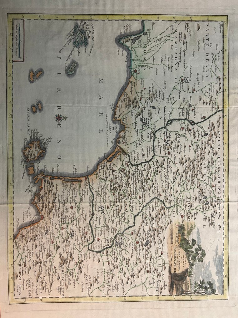
Italy - Terracina / Gaeta / Formia / Minturno / Cassino / Sora / Capua / Piedimonte / Southern Molise; Giovanni Battista Albrizzi - Carta Geografica della Terra di Lavoro o sia della Campagna Felice - 1721-1750

00
days
15
hours
40
minutes
30
seconds
Current bid
€ 73
No reserve price
Ilaria Colombo
Expert
Selected by Ilaria Colombo

Specialist in old books, specialising in theological disputes since 1999.

Estimate  € 140 - € 170
18 other people are watching this object
itBidder 7118 €73
itBidder 0991 €68
itBidder 8684 €63

Catawiki Buyer Protection

Your payment’s safe with us until you receive your object.View details

Trustpilot 4.4 | 121798 reviews

Rated Excellent on Trustpilot.

Map titled Carta Geografica della Terra di Lavoro o sia della Campagna Felice, published by Giovanni Battista Albrizzi, Italy, covering Terracina, Gaeta, Formia, Cassino, Capua and the surrounding Lazio and Campania, dimensions 330 × 430 mm, copper engraving with later hand colouring, in excellent condition.

AI-assisted summary

Description from the seller

The map shows a large portion of southern Lazio and northern Campania, including the areas of Terracina, Gaeta, Formia, Cassino, Capua, and the inland territory extending toward Molise and Abruzzo. The representation is rich in topographical detail, with densely hatched reliefs and a dense network of residential centers. The western portion is dominated by the Tyrrhenian Sea, where the Pontine Islands (Ponza, Palmarola, Zannone, and Gavi) are clearly visible, and further south, the entire Phlegraean Archipelago, with Ischia, Procida, and Vivara depicted with clearly recognizable coastlines. The overall map combines inland territories, the Tyrrhenian coast, and archipelagos, offering a broad and vivid representation of the ancient Campagna Felice.

The map shows a large portion of southern Lazio and northern Campania, including the areas of Terracina, Gaeta, Formia, Cassino, Capua, and the inland territory extending toward Molise and Abruzzo. The representation is rich in topographical detail, with densely hatched reliefs and a dense network of residential centers. The western portion is dominated by the Tyrrhenian Sea, where the Pontine Islands (Ponza, Palmarola, Zannone, and Gavi) are clearly visible, and further south, the entire Phlegraean Archipelago, with Ischia, Procida, and Vivara depicted with clearly recognizable coastlines. The overall map combines inland territories, the Tyrrhenian coast, and archipelagos, offering a broad and vivid representation of the ancient Campagna Felice.

Details

Era
1400-1900
Number of items
1
Country
Italy
Geographical specification
Terracina / Gaeta / Formia / Minturno / Cassino / Sora / Capua / Piedimonte / Southern Molise
Map maker/ publisher
Giovanni Battista Albrizzi
Map/ Book title
Carta Geografica della Terra di Lavoro o sia della Campagna Felice
Period
1721-1750
Condition
Excellent
Technique
Copper engraving
Additional Information
The newest atlas containing all parts of the world.
Map colour
Later hand colour
Height
330 mm
Width
430 mm
Sold by
ItalyVerified
3189
Objects sold
100%
protop

Similar objects

For you in

Maps