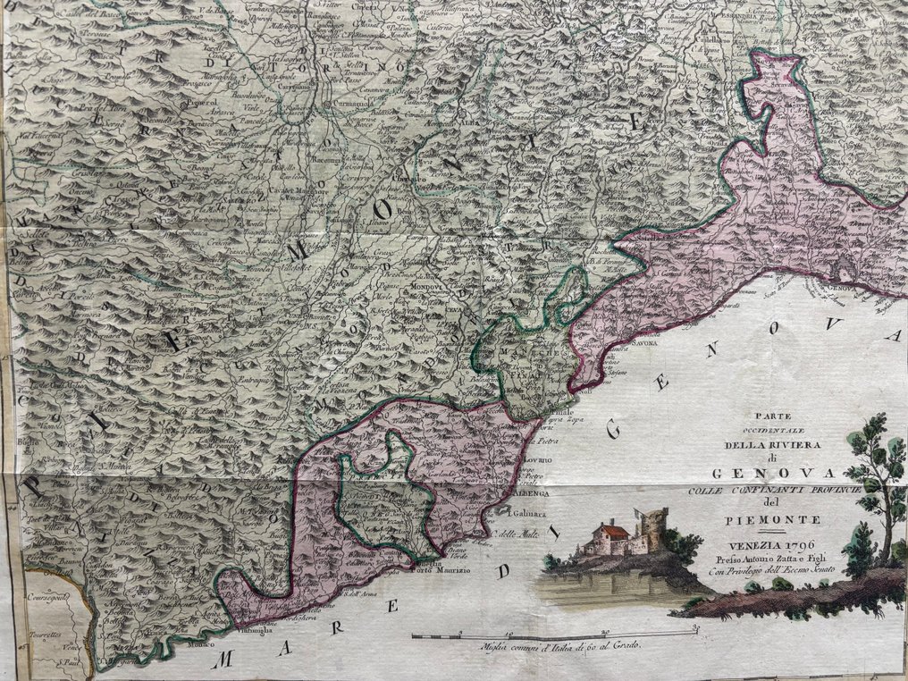
Italy - Liguria; Antonio Zatta - Parte Occidentale della Riviera di Genova - 1781-1800

00
days
16
hours
07
minutes
50
seconds
Current bid
€ 31
No reserve price
Ilaria Colombo
Expert
Selected by Ilaria Colombo

Specialist in old books, specialising in theological disputes since 1999.

Estimate  € 140 - € 210
23 other people are watching this object
itBidder 9815 €31
itBidder 2806 €22
itBidder 9815 €15

Catawiki Buyer Protection

Your payment’s safe with us until you receive your object.View details

Trustpilot 4.4 | 121798 reviews

Rated Excellent on Trustpilot.

Map titled Parte Occidentale della Riviera di Genova by Antonio Zatta, Italy, depicting Liguria; aquaforte technique with hand coloring; condition good.

AI-assisted summary

Description from the seller

Eighteenth-century map depicting the Genoa Riviera, including the Ligurian coastline and the mountainous areas bordering Piedmont. The map features a rich mountainous hatching in typical Zattian style and hand-colored political boundaries. The lower right section features a decorative vignette depicting a landscape with rural buildings, a distinctive feature of the Venetian publisher's graphic design. The sheet is generally well preserved, with book folds, slight paper undulations, and some cracks and small losses in the margins, particularly on the right edge. Localized foxing is present. The coloring is intact and the engraving is well legible.

Eighteenth-century map depicting the Genoa Riviera, including the Ligurian coastline and the mountainous areas bordering Piedmont. The map features a rich mountainous hatching in typical Zattian style and hand-colored political boundaries. The lower right section features a decorative vignette depicting a landscape with rural buildings, a distinctive feature of the Venetian publisher's graphic design. The sheet is generally well preserved, with book folds, slight paper undulations, and some cracks and small losses in the margins, particularly on the right edge. Localized foxing is present. The coloring is intact and the engraving is well legible.

Details

Era
1400-1900
Manufacturer/ Brand
Antonio Zatta
Country
Italy
Geographical specification
Liguria
Map maker/ publisher
Antonio Zatta
Map/ Book title
Parte Occidentale della Riviera di Genova
Period
1781-1800
Condition
Good
Technique
Etching
Additional Information
Latest Atlas
Map colour
Later hand colour
Height
37 cm
Width
47.5 cm
Sold by
ItalyVerified
475
Objects sold
100%
Private

Similar objects

For you in

Maps