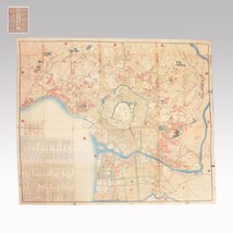
Japan - Antique Edo Period “Oedo Large Map” – 1852 Kaei 5 Revised Edition – Woodblock Print Folding Map; Woodblock Print Folding Map - Antique Edo Period “Oedo Large Map” - 1851-1860


Opens 11:00
Starting bid
€ 1
Add to your favourites to get an alert when the auction starts.

Expert
Selected by Ilaria Colombo
Specialist in old books, specialising in theological disputes since 1999.
Estimate € 700 - € 1,000
Catawiki Buyer Protection
Your payment’s safe with us until you receive your object.View details
Trustpilot 4.4 | 122290 reviews
Rated Excellent on Trustpilot.
Description from the seller
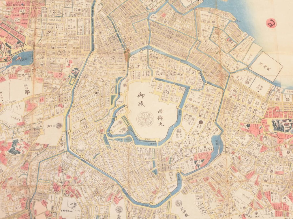
This is an authentic Edo-period woodblock-printed map titled “Oedo Oezu” (Large Map of Edo), revised in Kaei 5 (1852).
A beautifully hand-colored folding map showing Edo (present-day Tokyo) in exceptional detail, including the castle area, major districts, temples, waterways, and official residences.
The map is produced in a traditional Japanese orihon accordion-fold format and is printed on washi paper. This example includes the original front and back covers, consistent with mid-19th-century map production.
Date
Kaei 5 (嘉永五年) — 1852, late Edo period
(Revised edition as stated in the printed notes)
Condition
The main sheet shows age toning, stains along folds, and small tears at fold ends due to age.
The original covers exhibit rubbing, wear, and surface dulling.
Considering its age (over 170 years old), the map remains in generally good condition and retains strong color and readability.
Notes
This is a genuine period woodblock map, not a modern reproduction. Edo maps from this period are highly collectible, especially large-format versions depicting the castle town layout before major urban changes of the late 19th century.
Popular Search Keywords(1語のみ・重複なし)
Edo
map
Japan
antique
woodblock
washi
folding
Tokyo
historical
cartography
Kaei
original
【Important Information】
・International customers are responsible for any import duties, taxes, and fees not included in the item price or shipping costs. Please note that the VAT paid to Catawiki is separate from and does not include your country's import duties or customs clearance fees. Additional charges may be levied upon delivery at the discretion of your local customs authorities. We strongly advise checking with your country's customs office regarding these potential additional costs before bidding or purchasing. Prompt payment of these charges ensures timely delivery.
・Delivery Details: Most items are shipped via Japan Post (airmail). Upon request, delivery via DHL or FedEx can be arranged at an additional cost.
・Damage or Issues: Should you receive a damaged item, please contact us immediately before leaving a negative review. We appreciate your understanding and cooperation. For damage claims, please report to your nearest post office within 7 days of delivery. Please also promptly contact us and Catawiki Support.
・Due to the suspension of the “de minimis” exemption in the United States, import duties may be higher for shipments to the US. US bidders should be aware of this. As EMS shipments to the US are currently suspended, we will ship via DHL. Shipping costs will be higher than before; we appreciate your understanding.
Details
Era
1400-1900
Number of items
1
Country
Japan
Geographical specification
Antique Edo Period “Oedo Large Map” – 1852 Kaei 5 Revised Edition – Woodblock Print Folding Map
Map maker/ publisher
Woodblock Print Folding Map
Map/ Book title
Antique Edo Period “Oedo Large Map”
Period
1851-1860
Condition
Reasonable
Additional Information
“Oedo Large Map”
Map colour
Printed in colour
Height
134 cm
Width
121 cm
Sold by
