Affiche original - EUROPE AT THE TIME OF THE CRUSADES


00
days
03
hours
40
minutes
07
seconds
Current bid
€ 95
No reserve price

Expert
Selected by Ashley Calvert
He has 15 years of experience trading 20th century glass and antiques.
Estimate € 110 - € 160
49 other people are watching this object
 Bidder 5380 Bidder 5380 | €95 | |
|---|---|---|
 Bidder 8519 Bidder 8519 | €90 | |
| Bidder 5380 | €85 | |
Catawiki Buyer Protection
Your payment’s safe with us until you receive your object.View details
Trustpilot 4.4 | 122630 reviews
Rated Excellent on Trustpilot.
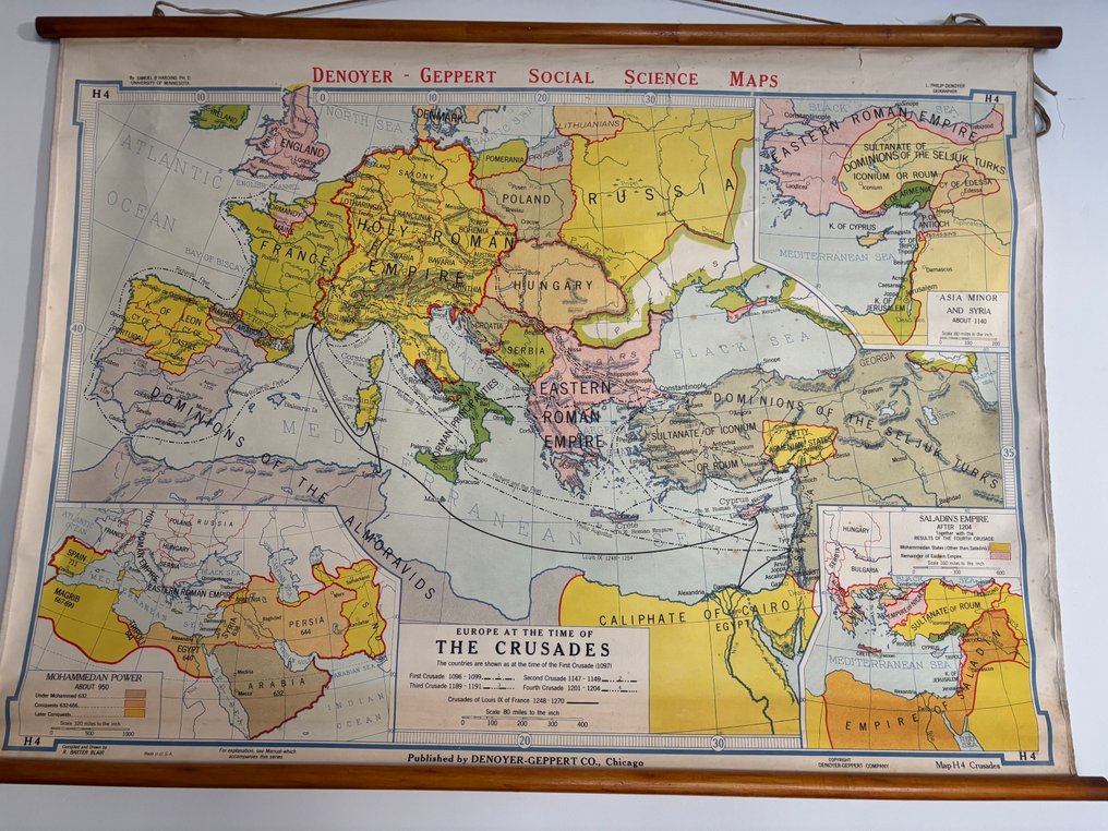
Original poster by Denoyer-Geppert Co., Chicago, titled Europe at the Time of the Crusades, in A- condition with minor imperfections, measuring 80 by 115 cm and mounted on canvas/linen with wooden hanging battens.
AI-assisted summary
Description from the seller
A historical and educational collectible piece: an original large wall school map for teaching history and geography, published by the renowned American company Denoyer-Geppert Co., Chicago.
H4 - Europe at the time of the Crusades (Europe at the time of the Crusades).
Publisher: DENOYER - GEPPERT SOCIAL SCIENCE MAPS, CHICAGO.
Publication period: Although not precisely dated on the photo, this style and series are typical of school editions produced by Denoyer-Geppert between the 1930s and 1950s. It is an original edition from the period.
Subject: Historical map illustrating Europe, the Middle East, and North Africa during the Crusades (from the 11th to the 13th century). It details the kingdoms, empires (Holy Roman Empire, Byzantine Empire, Seljuk Sultanate), caliphates, and traces the routes of the main Crusades (First, Second, Third, etc.).
Additional boxes: The map includes detailed sections outlining Saladin's Empire after 1193 and the Mohammadan Power during this period.
Material: Map printed on paper, then mounted on a solid canvas/linen (typical method of old school maps) with wooden suspension rods (top and bottom) for easy hanging.
Historical and Decorative Interest
This object is a fascinating document for historians and enthusiasts of the Middle Ages and the Crusades. Beyond its educational value, its retro aesthetic—sepia/pastel colors, period typography—makes it a highly sought-after decorative item. It is ideal for an office, a library, a vintage-inspired living room, or for any lover of antique cartography.
Details
Era
1900-2000
Designer/Artist
Affiche original
Poster title
EUROPE AT THE TIME OF THE CRUSADES
Condition
A- (fine - tiny imperfections)
Height
80 cm
Width
115 cm