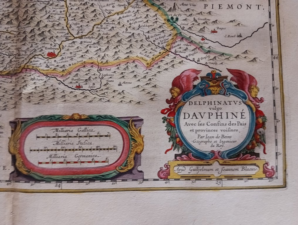
France - Dauphiné; BEINS, Jean de (1577-1651),BLAEU, Willem (1571-1638); BLAEU, Joan (1596-1673). - DELPHINATUS VULGO DAUPHINÉ avec ses confins des pais et provinces voisines / Par Jean de Beins - 1651-1660

05
days
16
hours
22
minutes
29
seconds
Starting bid
€ 1
Reserve price not met
Ilaria Colombo
Expert
Selected by Ilaria Colombo

Specialist in old books, specialising in theological disputes since 1999.

Estimate  € 150 - € 250
No bids placed

Catawiki Buyer Protection

Your payment’s safe with us until you receive your object.View details

Trustpilot 4.4 | 121798 reviews

Rated Excellent on Trustpilot.

Map titled 'DELPHINATUS VULGO DAUPHINÉ avec ses confins des pais et provinces voisines' by Jean de Beins, published by Blaeu (Willem and Joan Blaeu), France, Dauphiné.

AI-assisted summary

Description from the seller

Dauphiné, commonly known as Dauphiné, with its borders adjoining neighboring lands and provinces / By Jean de Beins, Geographer and Engineer to the King

Colorful engraving on paper, featuring the map of the Dauphiné region, one of the oldest provinces of France with Grenoble as its capital.

The title of the card is presented in a label, in the lower right corner.
The coat of arms of Dauphiné is depicted in the upper right corner, surrounded by the Order of the Holy Spirit.

The lines of the engraving are sharp and not blurry, with a fold mark in the middle. No damage or missing parts.

Coming from a 17th-century atlas, see verso.
Dim. 52 x 64 cm.

Details

Era
1400-1900
Number of items
1
Country
France
Geographical specification
Dauphiné
Map maker/ publisher
BEINS, Jean de (1577-1651),BLAEU, Willem (1571-1638); BLAEU, Joan (1596-1673).
Designer/Artist/Maker
BLAEU
Map/ Book title
DELPHINATUS VULGO DAUPHINÉ avec ses confins des pais et provinces voisines / Par Jean de Beins
Period
1651-1660
Condition
Good
Technique
Copper engraving
Additional Information
Blaeu
Map colour
Later hand colour
Height
52 cm
Width
62 cm
Sold by
FranceVerified
New
on Catawiki
Private

Similar objects

For you in

Maps