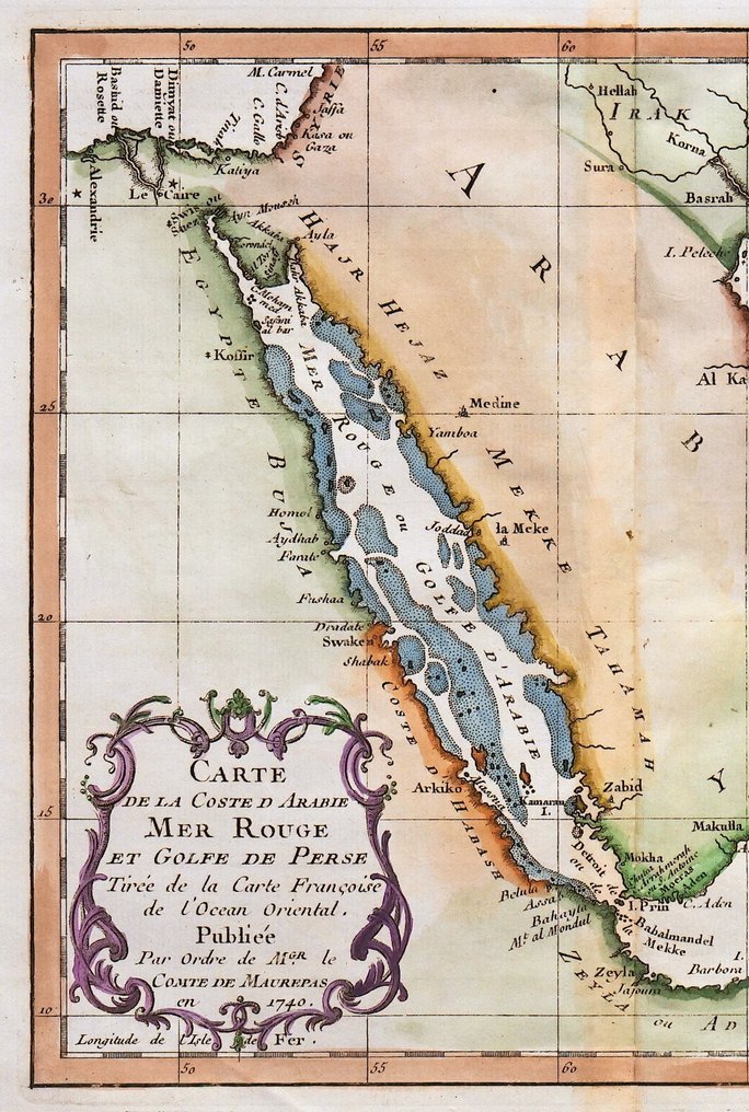
Middle East - Saudi Arabia, Yemen, Oman, United Arab Emirates, Qatar, Red Sea.; N. Bellin - Carte de la Coste d'Arabie, Mer Rouge et Golfe de Perse - 1751-1760

06
days
15
hours
39
minutes
06
seconds
Current bid
€ 1
No reserve price
Ilaria Colombo
Expert
Selected by Ilaria Colombo

Specialist in old books, specialising in theological disputes since 1999.

Estimate  € 110 - € 170
7 other people are watching this object
itBidder 7288 €1

Catawiki Buyer Protection

Your payment’s safe with us until you receive your object.View details

Trustpilot 4.4 | 121798 reviews

Rated Excellent on Trustpilot.

Carte de la Coste d'Arabie, Mer Rouge et Golfe de Perse, copper engraving by N. Bellin, published by Didot in Paris, covering the Middle East including Saudi Arabia, Yemen, Oman, United Arab Emirates, Qatar and the Red Sea, dimensions 25 x 34 cm.

AI-assisted summary

Description from the seller

Dimensions: 22 x 25 cm. (on sheet: 25 x 34 cm.).

Very good condition.
Back: blank.

Author: Antoine Francois Prevost
Mapmaker: N. Bellin
Publisher: Didot. Paris.
Note: from 'General History of Voyages or New Collection of All Travel Accounts'.

Jacques-Nicolas Bellin (1703-1772) was among the most important mapmakers of the eighteenth century. In 1721, at only the age of 18, he was appointed Hydrographer to the French Navy. In August 1741, he became the first Engineer of the Navy of the Depot of Maps and Plans of the Navy. Bellin set a very high standard of workmanship and accuracy, cementing France's leading role in European cartography and geography during this period. Many of his maps were copied by other mapmakers across the continent.

Details

Era
1400-1900
Number of items
1
Country
Middle East
Geographical specification
Saudi Arabia, Yemen, Oman, United Arab Emirates, Qatar, Red Sea.
Map maker/ publisher
N. Bellin
Map/ Book title
Carte de la Coste d'Arabie, Mer Rouge et Golfe de Perse
Period
1751-1760
Condition
Excellent
Technique
Copper engraving
Additional Information
Original antique copper engraving
Map colour
Later hand colour
Height
25 cm
Width
34 cm
Sold by
ItalyVerified
4325
Objects sold
100%
protop

Similar objects

For you in

Maps