Germany - Dithmarschen; P.Bertius/B.Langenes - Thietmarsia - 1581-1600

05
days
13
hours
11
minutes
42
seconds
Starting bid
€ 1
No reserve price

Expert
Selected by Ilaria Colombo
Specialist in old books, specialising in theological disputes since 1999.
Estimate € 170 - € 210
No bids placed
Catawiki Buyer Protection
Your payment’s safe with us until you receive your object.View details
Trustpilot 4.4 | 121798 reviews
Rated Excellent on Trustpilot.
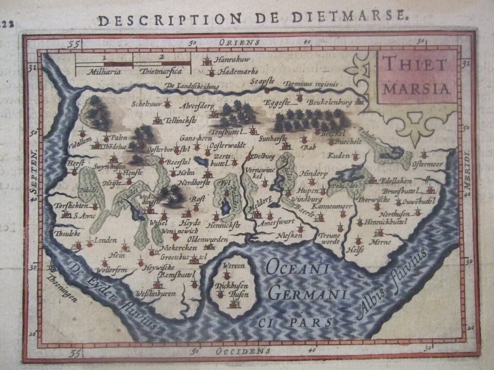
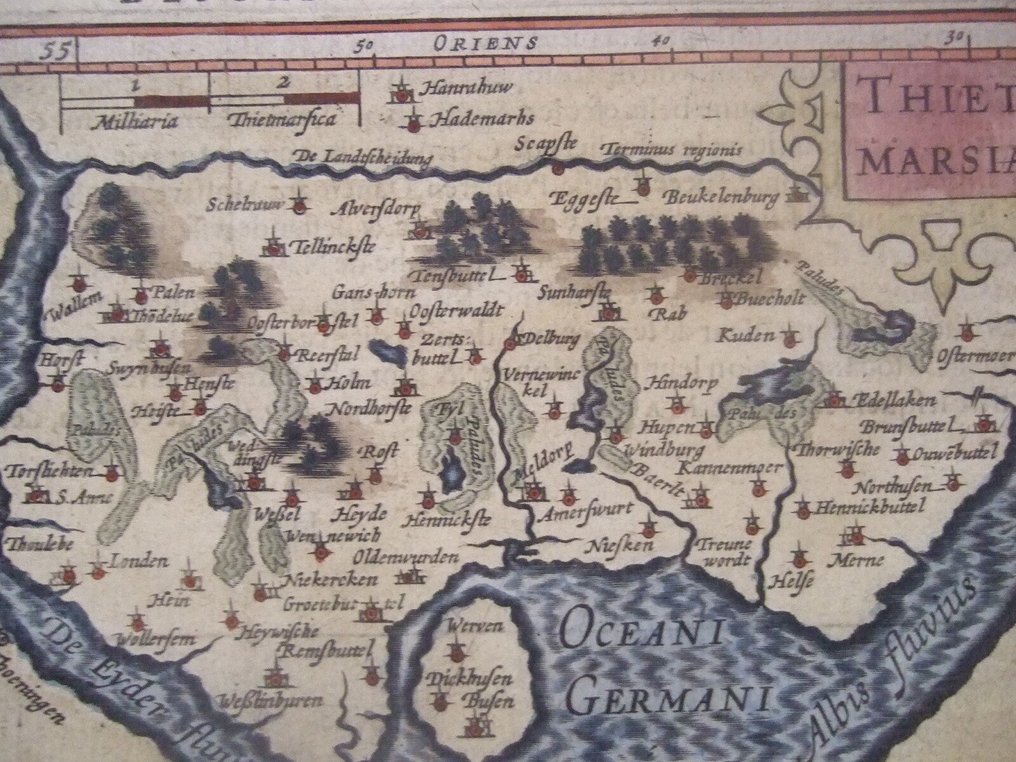
Thietmarsia is a copper-engraved map of Dithmarschen by Petrus Bertius and Barent Langenes, published in Middelburg in 1598, measuring 140 by 100 millimetres with contemporary hand colour and in good condition.
AI-assisted summary
Description from the seller
Sorry, no shipping to the USA right now !
1598, beautiful and detailed Map of Dithmarschen, a once independent Peasant Republic !
by Petrus Bertius , published by Barent Langenes in Middelburg/NL, from their 'Caert Tresoor'
in good condition , small tear in lower margin - small stain in upper margin, these not affecting the map.
Very decorative !
shipping by registered mail only
Dithmarschen is a district in Schleswig-Holstein, Germany. It is bounded by the districts of Nordfriesland, Schleswig-Flensburg, Rendsburg-Eckernförde, and Steinburg, by the state of Lower Saxony, and by the North Sea. From the 13th century up to 1559 Dithmarschen was an independent peasant republic within the Holy Roman Empire and a member of the Hanseatic League. It repulsed attempts by larger fiefs to annex it, whether physically or legally
Langenes, Barent
Barent Langenes (fl. 1598-1609) was a publisher of Middelburg, Netherlands. Little is known of him except that he wrote the text for and printed Caert-Thresoor, a pocket atlas initially published in Dutch by Cornelis Claesz in 1598, with later Dutch editions published to 1609. Latin editions were published (also by Cornelis Claesz) with text by Petrus Bertius from 1600. It was also translated into French and German. The engravers included Pieter van den Keere and Jodocus Hondius. In Atlantes Neerlandici, Koeman opines that "it sets a new standard for minor atlases. The small maps are extremely well-engraved: neat and clear, elegantly composed".
Bertius, Petrus
Petrus Bertius (November 14, 1565 – October 12, 1629), also known as Peter Bardt and P. Bertii, was a Flemish theologian, historian, and cartographer. Bertius was born in Beveren (Alveringem), a son of the preacher Pieter Michielszoon Bardt. The Bardt family fled to London at the outbreak of the Dutch War of Independence in 1568, fleeing both religious and political strife. When the political situation in the Netherlands stabilized in 1577, Bertius returned to study at the University of Leiden. He supported himself by tutoring until 1593 when he was appointed subregent of the Leiden Statencollege. This was probably a nepotistic post as, in the same year, he married Maritgen Kuchlinus, the daughter of Johannes Kuchlinus, then regent of the Statencollege. Bertius himself succeeded Johannes, becoming regent in 1606. Through his marriage, Bertius associated with Flemish cartographers Jodocus Hondius and Pieter van den Keere, both of whom were in-laws. Bertius first began publishing cartographic works in 1598 when, working with Barent Langenes, he published the miniature Latin language atlas Tabulae contractae. In 1618, publishing with his brother-in-law Jodocus Hondius, he issued the atlas Theatrum Geographiae Veteris, which impressed Louis XIII of France sufficiently that he relocated to Paris to take position as court cosmographer to the King. Two years later he converted to Catholicism and took a position teaching rhetoric at the Collège de Boncourt, in Paris. In 1622, Louix XIII granted him a chart in mathematical sciences at the royal college and the honorarium of royal historian. Bertius remained in Paris until his death in 1629.
Details
Era
1400-1900
Number of items
1
Country
Germany
Geographical specification
Dithmarschen
Map maker/ publisher
P.Bertius/B.Langenes
Map/ Book title
Thietmarsia
Period
1581-1600
Condition
Good
Technique
Copper engraving
Additional Information
1598,Very beautiful and detailed Map of Dithmarschen !
Map colour
Contemporary hand colour
Height
140 mm
Width
100 mm
Sold by
