France - World; Eustache Hyacinthe Langlois - Lot of three prints “Mappe-Monde” - 1781-1800


Opens 11:00
Starting bid
€ 1
Add to your favourites to get an alert when the auction starts.

Expert
Selected by Ilaria Colombo
Specialist in old books, specialising in theological disputes since 1999.
Estimate € 130 - € 200
Catawiki Buyer Protection
Your payment’s safe with us until you receive your object.View details
Trustpilot 4.4 | 121798 reviews
Rated Excellent on Trustpilot.
Description from the seller
Miniature World Map
World map engraved on copper and hand-colored, in rectangular projection, with the title “Mappe-Monde Réduite”. The map shows the world according to the geographical knowledge of the time: Australia is indicated as Nouvelle Hollande, North America features still uncertain territories, while vast areas of the Arctic remain schematic or unexplored. Political divisions are highlighted with watercolor outlines.
The table includes the meridians referring to Île de Fer and the Paris meridian, a characteristic of French cartography from the late eighteenth century.
The input is a dash character, which does not require translation.
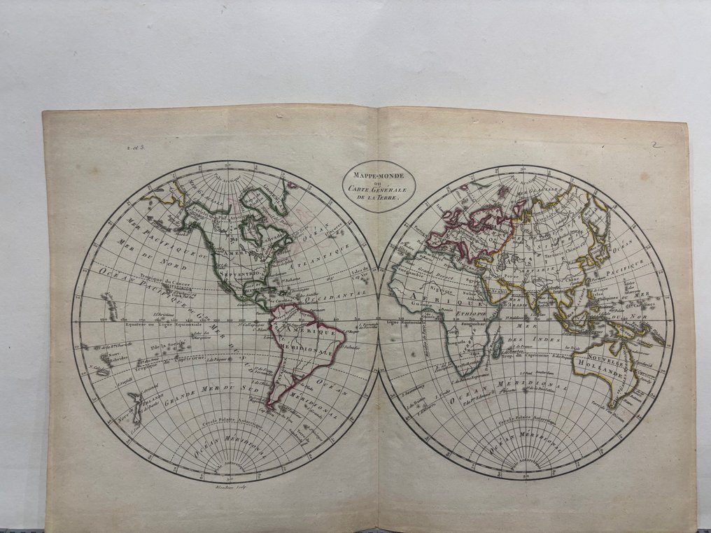
2. 'World Map, or General Map of the Earth' – Projection of two hemispheres
Hand-engraved colored copper depicting the world in a double hemispheric projection: the Western Hemisphere on the left, the Eastern Hemisphere on the right. The title “Mappe-Monde ou Carte Générale de la Terre” is inscribed between the two globes.
The map shows recent geographical discoveries for the period: still semi-defined Pacific coasts, Nouvelle Hollande not fully delineated, the presence of maritime routes and the lines of the tropics. The hemispheric projection, elegant and scientific, is typical of the Enlightenment. The colored outlines highlight the main political entities.
The input is a dash character, which does not require translation.
Sphere Armillaire
Monochrome engraving on copper depicting an armillary sphere, a traditional astronomical instrument composed of movable rings representing the fundamental elements of the celestial sphere: the equator, ecliptic, colures, meridian, and horizon. The central globe represents the Earth, according to the geocentric model used in educational instruments.
The image shows a sphere mounted on an elegantly decorated pedestal. At the top, in freehand, is written 'Cécile Corteau 1835,' probably a signature or ownership note of the owner from that period.
The prints are in good condition as per the photo.
Miniature World Map
World map engraved on copper and hand-colored, in rectangular projection, with the title “Mappe-Monde Réduite”. The map shows the world according to the geographical knowledge of the time: Australia is indicated as Nouvelle Hollande, North America features still uncertain territories, while vast areas of the Arctic remain schematic or unexplored. Political divisions are highlighted with watercolor outlines.
The table includes the meridians referring to Île de Fer and the Paris meridian, a characteristic of French cartography from the late eighteenth century.
The input is a dash character, which does not require translation.
2. 'World Map, or General Map of the Earth' – Projection of two hemispheres
Hand-engraved colored copper depicting the world in a double hemispheric projection: the Western Hemisphere on the left, the Eastern Hemisphere on the right. The title “Mappe-Monde ou Carte Générale de la Terre” is inscribed between the two globes.
The map shows recent geographical discoveries for the period: still semi-defined Pacific coasts, Nouvelle Hollande not fully delineated, the presence of maritime routes and the lines of the tropics. The hemispheric projection, elegant and scientific, is typical of the Enlightenment. The colored outlines highlight the main political entities.
The input is a dash character, which does not require translation.
Sphere Armillaire
Monochrome engraving on copper depicting an armillary sphere, a traditional astronomical instrument composed of movable rings representing the fundamental elements of the celestial sphere: the equator, ecliptic, colures, meridian, and horizon. The central globe represents the Earth, according to the geocentric model used in educational instruments.
The image shows a sphere mounted on an elegantly decorated pedestal. At the top, in freehand, is written 'Cécile Corteau 1835,' probably a signature or ownership note of the owner from that period.
The prints are in good condition as per the photo.
Details
Era
1400-1900
Manufacturer/ Brand
Eustache Hyacinthe Langlois
Country
France
Geographical specification
World
Map maker/ publisher
Eustache Hyacinthe Langlois
Map/ Book title
Lot of three prints “Mappe-Monde”
Period
1781-1800
Condition
Good
Technique
Etching
Additional Information
Universal Atlas, for Guthrie's geography.
Map colour
Later hand colour
Height
25 cm
Width
36 cm
