Belgium - Antique Map 'Allemagne – Deutschland' – Les Éditions STAR, Liège – circa 1918–1930 – Grote - Military accessories


04
days
15
hours
39
minutes
38
seconds
Starting bid
€ 1
No reserve price

Expert
Selected by Ilaria Colombo
Specialist in old books, specialising in theological disputes since 1999.
Estimate € 110 - € 170
No bids placed
Catawiki Buyer Protection
Your payment’s safe with us until you receive your object.View details
Trustpilot 4.4 | 121798 reviews
Rated Excellent on Trustpilot.
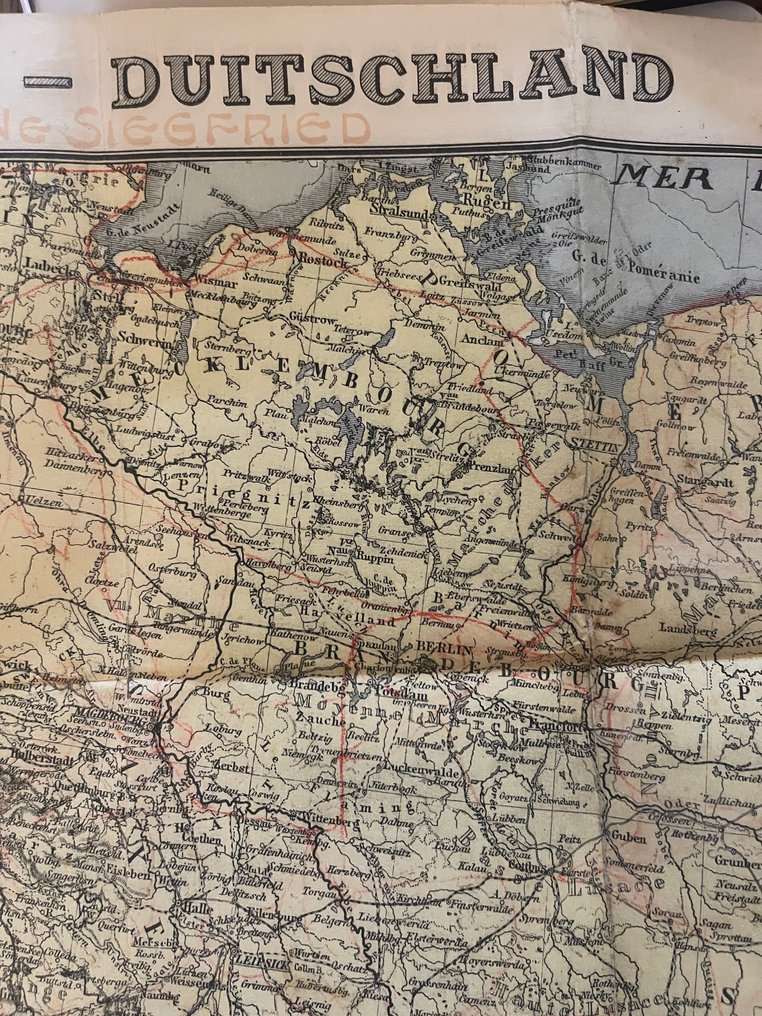
Antique map titled "Allemagne – Deutschland" published by Les Éditions STAR in Liège (Belgium), dating ca. 1918–1930, detailing Germany and surrounding regions at a scale of 1:1,500,000 in lithographic two-language French/Dutch legend.
AI-assisted summary
Description from the seller
Very detailed and originally printed map of Germany and the surrounding regions, published by Les Éditions STAR in Liège in the early 20th century. The map bears the bilingual title 'Allemagne – Deutschland' and includes both French and Dutch legend elements.
This map is a political-geographical publication, designed for education, administrative use, and cartographic documentation of European regions following the major territorial shifts at the beginning of the 20th century.
The publisher has included a clear scale bar, as well as symbols for national borders, railways, and rivers. Due to the large number of place names, railway lines, and administrative boundaries, this map is a valuable document for enthusiasts of historical geography and political history.
The symbol (⸻)
Publisher
Les Éditions STAR
1, Rue de la Solidarité, Liège
Commercial Register: R.C. Liège 19793
Reproduction prohibited / No reproduction allowed.
Original printed price: 18 Francs
This publisher was active in educational and political maps for schools and administrative institutions. Maps from STAR are relatively few on the market.
The symbol (⸻)
Dating
Style, typography, the countries mentioned, and the price indication suggest a publication from around 1918–1930, after the First World War but before the major reconfigurations of Europe in 1939–1945.
Features that support this.
Avoiding the use of Pruisen (Prussia / Preussen) as a provincial designation.
The mention of 'Slovaquie', which indicates the existence of Czechoslovakia (established in 1918).
The price '18F' before decimalization and before World War II.
The cartographic style typical of interwar publications.
The symbol (⸻)
Military relevance
Major railway lines, crucial for troop transport between 1870 and 1940, are clearly depicted.
The map showing the territorial situation of Germany and Central Europe during the Interwar period illustrates a time when borders, mandate areas, and spheres of influence were highly significant in military and political terms.
The title 'with the Siegfried line' (handwritten at the top) possibly refers to the Siegfried Line, an important German defensive line (from 1916 and later rebuilt in 1936–1939).
The symbol (⸻)
Cartographic features
• Scale: 1:1,500,000
Detailed color print (lithography)
Legend in two languages (French/Dutch)
Designations
State borders
Province borders
Hundreds of cities, villages, and river names.
Railway networks (connections between major cities)
Sea and gulf names such as Mer du Nord and Golfe de Dantzig.
at a very detailed level
Northern Germany
Pruisen
Brandenburg
Pommeren
Silesia
Austria and Hungary
Poland and Czechoslovakia
The symbol (⸻)
Condition
Original fold-out brochure in used but well-preserved condition.
Multiple fold lines, as is usual with cards of this type.
Light pollution and discoloration appropriate for age.
Small cracks or pressure wear along folds and edges.
• Paper is stable, complete, and the print is clear everywhere.
• Titelzone has some handwritten notes ('ligne Siegfried') from a previous owner.
See photos for an accurate picture of the condition.
Seller's Story
The Archive of Valor & Heritage is dedicated to preserving the tangible echoes of history — authentic militaria, medals, old documents, and historical collectibles.
Every item in our collection is hand-selected for its authenticity, craftsmanship, and the story it carries. From wartime decorations and field relics to archival papers and early toys, our aim is to connect collectors with genuine pieces of heritage that honor courage and the passage of time.
We believe that true collecting is not about owning objects, but about safeguarding history — one relic at a time.
Translated by Google TranslateVery detailed and originally printed map of Germany and the surrounding regions, published by Les Éditions STAR in Liège in the early 20th century. The map bears the bilingual title 'Allemagne – Deutschland' and includes both French and Dutch legend elements.
This map is a political-geographical publication, designed for education, administrative use, and cartographic documentation of European regions following the major territorial shifts at the beginning of the 20th century.
The publisher has included a clear scale bar, as well as symbols for national borders, railways, and rivers. Due to the large number of place names, railway lines, and administrative boundaries, this map is a valuable document for enthusiasts of historical geography and political history.
The symbol (⸻)
Publisher
Les Éditions STAR
1, Rue de la Solidarité, Liège
Commercial Register: R.C. Liège 19793
Reproduction prohibited / No reproduction allowed.
Original printed price: 18 Francs
This publisher was active in educational and political maps for schools and administrative institutions. Maps from STAR are relatively few on the market.
The symbol (⸻)
Dating
Style, typography, the countries mentioned, and the price indication suggest a publication from around 1918–1930, after the First World War but before the major reconfigurations of Europe in 1939–1945.
Features that support this.
Avoiding the use of Pruisen (Prussia / Preussen) as a provincial designation.
The mention of 'Slovaquie', which indicates the existence of Czechoslovakia (established in 1918).
The price '18F' before decimalization and before World War II.
The cartographic style typical of interwar publications.
The symbol (⸻)
Military relevance
Major railway lines, crucial for troop transport between 1870 and 1940, are clearly depicted.
The map showing the territorial situation of Germany and Central Europe during the Interwar period illustrates a time when borders, mandate areas, and spheres of influence were highly significant in military and political terms.
The title 'with the Siegfried line' (handwritten at the top) possibly refers to the Siegfried Line, an important German defensive line (from 1916 and later rebuilt in 1936–1939).
The symbol (⸻)
Cartographic features
• Scale: 1:1,500,000
Detailed color print (lithography)
Legend in two languages (French/Dutch)
Designations
State borders
Province borders
Hundreds of cities, villages, and river names.
Railway networks (connections between major cities)
Sea and gulf names such as Mer du Nord and Golfe de Dantzig.
at a very detailed level
Northern Germany
Pruisen
Brandenburg
Pommeren
Silesia
Austria and Hungary
Poland and Czechoslovakia
The symbol (⸻)
Condition
Original fold-out brochure in used but well-preserved condition.
Multiple fold lines, as is usual with cards of this type.
Light pollution and discoloration appropriate for age.
Small cracks or pressure wear along folds and edges.
• Paper is stable, complete, and the print is clear everywhere.
• Titelzone has some handwritten notes ('ligne Siegfried') from a previous owner.
See photos for an accurate picture of the condition.
Seller's Story
The Archive of Valor & Heritage is dedicated to preserving the tangible echoes of history — authentic militaria, medals, old documents, and historical collectibles.
Every item in our collection is hand-selected for its authenticity, craftsmanship, and the story it carries. From wartime decorations and field relics to archival papers and early toys, our aim is to connect collectors with genuine pieces of heritage that honor courage and the passage of time.
We believe that true collecting is not about owning objects, but about safeguarding history — one relic at a time.
Translated by Google TranslateDetails
Era
1900-2000
Army Unit
Antique Map 'Allemagne – Deutschland' – Les Éditions STAR, Liège – circa 1918–1930 – Grote
Country of Origin
Belgium
Condition
Good
Original/ Replica
Original
Comes with certificate of authenticity
No
Sold by
