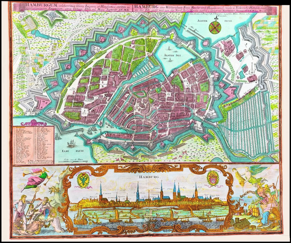
Germany - Hamburg City Map, Europe; Matthäus Seutter - Hamburg, the most famous free city of the Empire and the Hanseatic League - 1721-1750


10
days
17
hours
31
minutes
54
seconds
Current bid
€ 2
Reserve price not met

Expert
Selected by Ilaria Colombo
Specialist in old books, specialising in theological disputes since 1999.
Estimate € 850 - € 2,000
11 other people are watching this object
 Bidder 2790 Bidder 2790 | €2 | |
|---|---|---|
| Bidder 2790 | €1 |
Catawiki Buyer Protection
Your payment’s safe with us until you receive your object.View details
Trustpilot 4.4 | 122115 reviews
Rated Excellent on Trustpilot.
Hamburg, the most famous free city of the Empire and the Hanseatic League, by Matthäus Seutter (Germany) – Hamburg City Map, Europe; copper engraving, contemporary hand colour, good condition, 504 × 604 mm.
AI-assisted summary
Description from the seller
RARE DECORATIVE MAP OF HAMBURG CITY, GERMANY, EUROPE by Matthäus Seutter (1678-1757). PLEASE NOTE: the buyer will also receive a Certificate of Authenticity (COA). Printed in Augsburg around 1730-1740; the map bears in the upper right corner the printing privilege granted by the German Emperor Charles VI (Karl VI) in 1732, in his capacity as “Imperial Geographer”. In the lower third the ornamentally decorated prospect of the Hanseatic city of Hamburg framed with a rich allegorical cartouche. With Latin and German title in inscription band in upper margin and inscription field with legend 1-53 lower left above the view. Original copper engraving, beautiful colours, very good condition, with original margins, no particular cuts or defects to report, normal small imperfections due to time, laid paper with chain lines and watermark, please see the photo. To complete the documentation, the photo of the title of the work is also published with the name of the artists who created the prints. This map is one of the best German productions of the 1700s. Reference; Fauser, A.: Repertorium älterer Topographie, No. 5398.
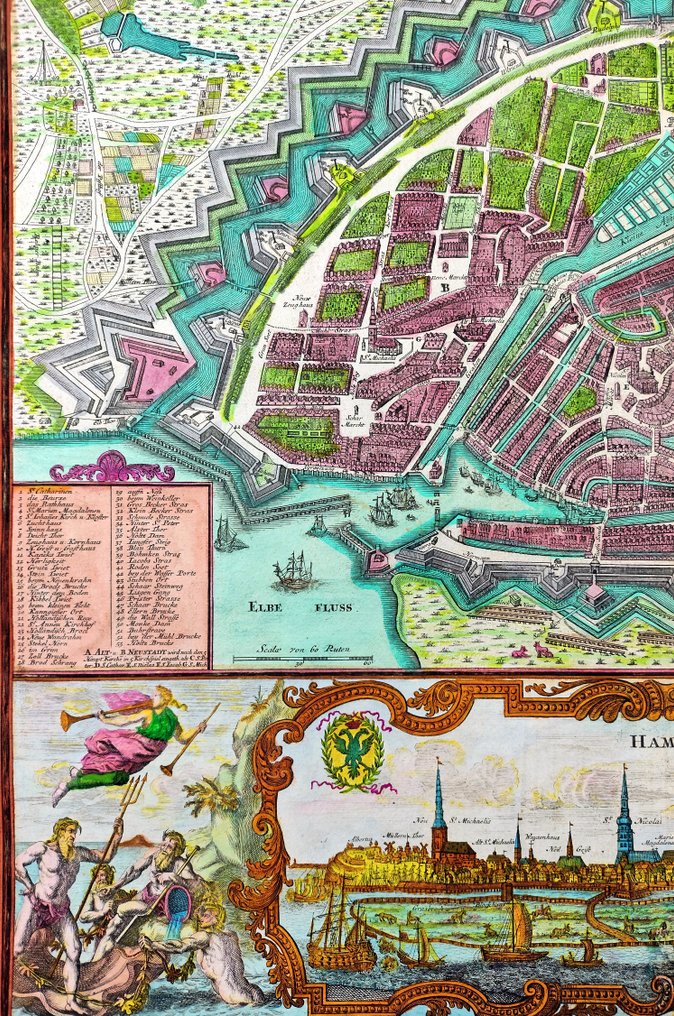
This highly detailed city map represents the Hamburg old town, harbor, fortress, churches, streets, gardens, cattles, Elbe river, and its surrounding countryside. The beautiful city is situated at the confluence of the Elbe and Alster Rivers and is protected by an extensive network of canals and fortification walls. Below is a finely engraved view of the city in a separate panel that names each of the city's churches and shows images of ships on the river and livestock in the fields. This supplemental view is surrounded by a decorative border and is adorned with allegorical figures. At the left margin is a numbered legend showing the locations of 53 important sites.
TITLE/DESCRIPTION: "Hamburgum, celeberrima libera Imperii et Hanseatica civitas ac opulentissimum Emporium, circa Ostium Albis ad Mare Septentr"...(Hamburg, the most famous free city of the Empire and the Hanseatic League and the most opulent market, near the mouth of the Elbe on the North Sea...). From the book; "Atlas Novus sive Tabulae Geographicae Totius Orbis Faciem" and printed in Augsburg around 1730-1740 by Matthäus Seutter. Sheet size height 504 x width 604 mm (19.9 by 23.8 inches). Laid paper with chain lines and watermark, centre fold as published, original margins, on the back remains of the original binding. The map is in very good condition with beautiful colours, images and text intact, few old restorations, small tears, normal small imperfections due to time as per photo. Text in german and latin. This map is one of the best German productions of the 1700s.
LITERATURE/REFERNCES: Michael Ritter, "Seutter, Probst and Lotter: a 18th-Century Map Publishing House", Imago Mundi, vol.53 (2001), pp. 130-135; Fauser, A.: Repertorium älterer Topographie, No. 5398; Campbell No. 59; Tooley p. 64; Philips 583; Shirley BL T.SEU-1a.
AUTHOR/CARTOGRAPHER: Matthäus Seutter (1678-1757) was a German map publisher of the 18th century. He moved to Nuremberg where he apprenticed as an engraver under the tutelage of the prominent J. B. Homann. Sometime in the early 18th century Seutter left Homann to establish his own independent cartographic publishing firm in Augsburg. Though he struggled in the early years of his independence, Seutter’s engraving skill and commitment to diversified map production eventually gained him a substantial following. Most of Seutter’s maps were heavily based upon, if not copies of, earlier work done by the Homann and Delisle firms. By 1732 Seutter was honored by the German Emperor Charles VI with the title of “Imperial Geographer”. Seutter continued to publish until his death, at the height of his career, in 1757.
SHIPPING: via UPS, DHL, National Postal Services, protected, INSURED and fully tracked package. Estimated time for Europe 3-5 working days. Shipping within one working day, you can combine shipping if you purchases several items from us, saving money and time.
RARE DECORATIVE MAP OF HAMBURG CITY, GERMANY, EUROPE by Matthäus Seutter (1678-1757). PLEASE NOTE: the buyer will also receive a Certificate of Authenticity (COA). Printed in Augsburg around 1730-1740; the map bears in the upper right corner the printing privilege granted by the German Emperor Charles VI (Karl VI) in 1732, in his capacity as “Imperial Geographer”. In the lower third the ornamentally decorated prospect of the Hanseatic city of Hamburg framed with a rich allegorical cartouche. With Latin and German title in inscription band in upper margin and inscription field with legend 1-53 lower left above the view. Original copper engraving, beautiful colours, very good condition, with original margins, no particular cuts or defects to report, normal small imperfections due to time, laid paper with chain lines and watermark, please see the photo. To complete the documentation, the photo of the title of the work is also published with the name of the artists who created the prints. This map is one of the best German productions of the 1700s. Reference; Fauser, A.: Repertorium älterer Topographie, No. 5398.
This highly detailed city map represents the Hamburg old town, harbor, fortress, churches, streets, gardens, cattles, Elbe river, and its surrounding countryside. The beautiful city is situated at the confluence of the Elbe and Alster Rivers and is protected by an extensive network of canals and fortification walls. Below is a finely engraved view of the city in a separate panel that names each of the city's churches and shows images of ships on the river and livestock in the fields. This supplemental view is surrounded by a decorative border and is adorned with allegorical figures. At the left margin is a numbered legend showing the locations of 53 important sites.
TITLE/DESCRIPTION: "Hamburgum, celeberrima libera Imperii et Hanseatica civitas ac opulentissimum Emporium, circa Ostium Albis ad Mare Septentr"...(Hamburg, the most famous free city of the Empire and the Hanseatic League and the most opulent market, near the mouth of the Elbe on the North Sea...). From the book; "Atlas Novus sive Tabulae Geographicae Totius Orbis Faciem" and printed in Augsburg around 1730-1740 by Matthäus Seutter. Sheet size height 504 x width 604 mm (19.9 by 23.8 inches). Laid paper with chain lines and watermark, centre fold as published, original margins, on the back remains of the original binding. The map is in very good condition with beautiful colours, images and text intact, few old restorations, small tears, normal small imperfections due to time as per photo. Text in german and latin. This map is one of the best German productions of the 1700s.
LITERATURE/REFERNCES: Michael Ritter, "Seutter, Probst and Lotter: a 18th-Century Map Publishing House", Imago Mundi, vol.53 (2001), pp. 130-135; Fauser, A.: Repertorium älterer Topographie, No. 5398; Campbell No. 59; Tooley p. 64; Philips 583; Shirley BL T.SEU-1a.
AUTHOR/CARTOGRAPHER: Matthäus Seutter (1678-1757) was a German map publisher of the 18th century. He moved to Nuremberg where he apprenticed as an engraver under the tutelage of the prominent J. B. Homann. Sometime in the early 18th century Seutter left Homann to establish his own independent cartographic publishing firm in Augsburg. Though he struggled in the early years of his independence, Seutter’s engraving skill and commitment to diversified map production eventually gained him a substantial following. Most of Seutter’s maps were heavily based upon, if not copies of, earlier work done by the Homann and Delisle firms. By 1732 Seutter was honored by the German Emperor Charles VI with the title of “Imperial Geographer”. Seutter continued to publish until his death, at the height of his career, in 1757.
SHIPPING: via UPS, DHL, National Postal Services, protected, INSURED and fully tracked package. Estimated time for Europe 3-5 working days. Shipping within one working day, you can combine shipping if you purchases several items from us, saving money and time.
Details
Era
1400-1900
Number of items
1
Country
Germany
Geographical specification
Hamburg City Map, Europe
Map maker/ publisher
Matthäus Seutter
Map/ Book title
Hamburg, the most famous free city of the Empire and the Hanseatic League
Period
1721-1750
Condition
Good
Technique
Copper engraving
Additional Information
Hand Colored Map
Map colour
Contemporary hand colour
Height
504 mm
Width
604 mm
Sold by
