Italy - Europe, Sardinia, Corsica, Slovenia, Croatia, Dalmatia, Greece, Montenegro, Albania; Willem Blaeu and François van den Hoeye - Map of Italy, Sardinia, Corsica - 1601-1620


Opens 11:00
Starting bid
€ 1
Add to your favourites to get an alert when the auction starts.

Expert
Selected by Ilaria Colombo
Specialist in old books, specialising in theological disputes since 1999.
Estimate € 850 - € 1,500
Catawiki Buyer Protection
Your payment’s safe with us until you receive your object.View details
Trustpilot 4.4 | 121798 reviews
Rated Excellent on Trustpilot.
Description from the seller
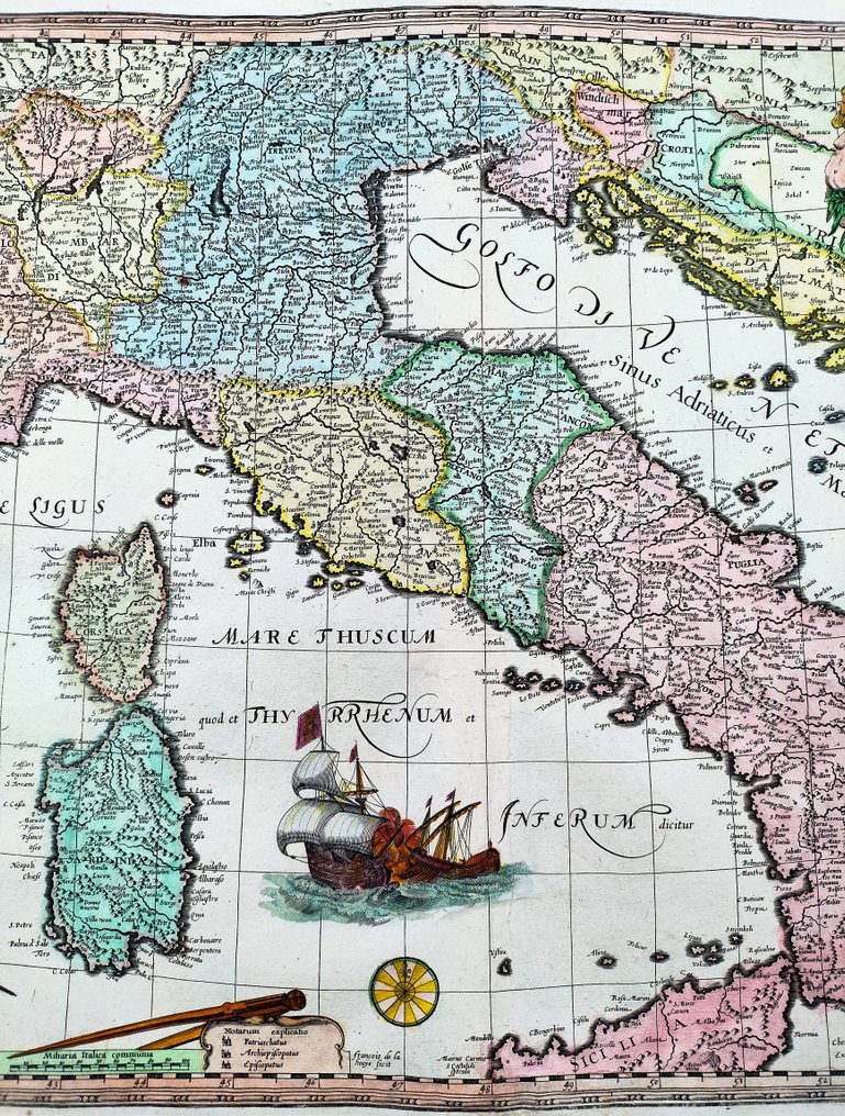
RARE MAP OF ITALY, SARDINIA, CORSICA, MEDITERRANEAN SEA, PART OF SLOVENIA, CROATIA, DALMATIA, GREECE, MONTENEGRO, ALBANIA and SOUTHERN EUROPE…created by the Dutch engraver François/Francis van den Hoeye (aka Franciscus Hoeius, 1590-1636), after Willem Janszoon Blaeu (1571-1638) rare carte-a-figures map of Italy, first published in 1606, and printed in 1610 by Jean Le Clerc (1560-1622), in Paris, as written in the margin below. PLEASE NOTE: the buyer will also receive a Certificate of Authenticity (COA). Genuine antique copper engraving, beautiful colours, very good condition, no particular cuts or defects to report, normal small imperfections due to time as per photo, laid paper with chain lines and TWO watermarks as per photo, centre fold as published, on the back remains of the original binding, please see the photo. References; G. Schilder, Monumenta Cartographica Neerlandica, vol. VI, pp. 55/63 e 367/370, 89; Borri, Italy in ancient maps from the Middle Ages to national unification, p. 97, 89; Bibliothèque Nationale de France https://gallica.bnf.fr/ark:/12148/btv1b532236177/
TITLE/DESCRIPTION: "Italiae, Sardiniae, Corsicae et confinium Regionum nova tabula, effigies praecipuarum Urbium et habituum inibi simul complectens..." (A new map of Italy, Sardinia, Corsica and the bordering regions, including the portraits of the principal cities and their customs...). Printed in Paris, 1610. Sheet size height 418 x width 564 mm (16.5 by 22.2 inches). The rare map derives from Gerard Mercator's version of Italy first published in 1589, and Willem Janszoon Blaeu's rare carte-a-figures map of Italy, first published in 1606 and here re-engraved and adapted without the figures by François/Francis van den Hoeye in 1610. The map is richly embellished with allegorical figures, ships, naval battles, period clothing, a compass, units of measurement, and the legend of the she-wolf suckling the first kings of Rome. The map shows the situation of the states and kingdoms of the first era of unification of Italy: Republic of Venice, Kingdom of Naples, Kingdom of Sicily, State of the Church, State of Presìdi, Republic of Genoa, Kingdom of Sardegna, Republic of Lucca, Marquisate of Monferrato, Marquisate of Saluzzo, Duchy of Savoia, Toscana, Milano, Parma, Modena, Mantova, Ferrara.
AUTHOR/CARTOGRAPHER: François/Francis van den Hoeye (aka Franciscus Hoeius, 1590-1636) worked in Paris and Amsterdam as a copper plate engraver and publisher until his death in 1636 (Schilder, 1979). Van der Hoeye is known to have acquired and re-issued several multi-sheet world maps published originally by Mercator, Blaeu and Hondius. In addition to this map of Italy, Van den Hoeye also produced other maps for the French publisher Jean Le Clerc, who was responsible for the publication of one of the first geographical atlases of France.
AUTHOR/CARTOGRAPHER: Jean Leclerc (1560-1622), was a French geographer, copperplate engraver, printer and publisher, mainly active in Paris. He was also known as Jean Le Clerc IV, Jean Le Clerc le fils, Jean Le Clerc le jeune. He was born into the French Wars of Religion, which only ended when he was thirty-eight, and as a Huguenot he fled Paris in 1588 and spent a year elsewhere in France. He gained royal concessions under kings Henri IV and Louis XIII and developed a huge publishing business, collaborating with several engravers and publishing maps, images of contemporary events and other works, including an atlas of France.
SHIPPING: via UPS, DHL, National Postal Services, protected, INSURED and fully tracked package. Estimated time for Europe 3-5 working days. Shipping within one working day, you can combine shipping if you purchases several items from us, saving money and time.
Details
Era
1400-1900
Number of items
1
Country
Italy
Geographical specification
Europe, Sardinia, Corsica, Slovenia, Croatia, Dalmatia, Greece, Montenegro, Albania
Map maker/ publisher
Willem Blaeu and François van den Hoeye
Map/ Book title
Map of Italy, Sardinia, Corsica
Period
1601-1620
Condition
Good
Technique
Copper engraving
Additional Information
Hand Colored Map
Map colour
Contemporary hand colour
Height
418 mm
Width
564 mm
Sold by
