France - Europe – December 1939 – Original Large Map – WWII / WW2 – L’Illustration – Rare - Military accessories - 1939


05
days
15
hours
52
minutes
40
seconds
Starting bid
€ 1
No reserve price

Expert
Selected by Ilaria Colombo
Specialist in old books, specialising in theological disputes since 1999.
Estimate € 120 - € 170
No bids placed
Catawiki Buyer Protection
Your payment’s safe with us until you receive your object.View details
Trustpilot 4.4 | 121798 reviews
Rated Excellent on Trustpilot.
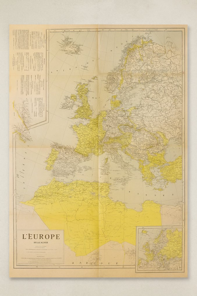
L’Europe – Décembre 1939, published by L’Illustration in Paris, France, is an original 1939 map of Europe at the start of World War II.
AI-assisted summary
Description from the seller
Beautiful and very rare original map of Europe from December 1939, published as a supplement in the French magazine L’Illustration.
This map shows Europe at the beginning of World War II, accurately depicting all borders, occupied areas, and strategic zones at the time.
A historically valuable piece, especially for collectors of militaria, cartography, and WWII memorabilia.
Details
Europe – December 1939
• Publisher: L’Illustration, Paris
Print: Supplement to the issue of January 6, 1940 (mentioned on the map).
Scale: 1:7,500,000
• Format: Large fold-out format (approximately ± 90 × 60 cm)
• Material: Thin cardboard paper, original print
Language: French.
• Colors: hand tint (yellow and gray) as is typical for pre-war maps.
Theme: Europe in the early phase of WWII
Particulars
Detailed display of
German occupation zones (1939)
Borders of Poland, Russia, Czechoslovakia, etc.
• Geographical data and contour lines
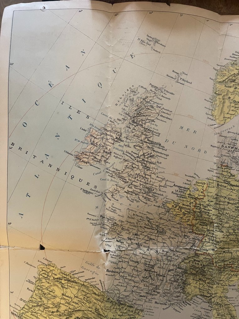
All cities, railways, rivers, and strategic areas.
Bottom left legend with symbols for boundaries, troop movements, and occupied area.
The card is authentic (not a reprint) and bears clear signs of age.
Condition
In good condition for its age (84 years old)
Fold a few times by folding.
Small cracks at the edges and center fold (see photos).
Minimal discoloration due to aging.
Overall, very good condition and excellent for framing.
Origin
Private collection
No reproduction – guaranteed original material from 1939/1940.
Suitable for:
Militaria collectors
Historians
Cartography enthusiasts
Interior decoration – beautiful as a framed wall map.
museum presentation
Seller's Story
The Archive of Valor & Heritage is dedicated to preserving the tangible echoes of history — authentic militaria, medals, old documents, and historical collectibles.
Every item in our collection is hand-selected for its authenticity, craftsmanship, and the story it carries. From wartime decorations and field relics to archival papers and early toys, our aim is to connect collectors with genuine pieces of heritage that honor courage and the passage of time.
We believe that true collecting is not about owning objects, but about safeguarding history — one relic at a time.
Translated by Google TranslateBeautiful and very rare original map of Europe from December 1939, published as a supplement in the French magazine L’Illustration.
This map shows Europe at the beginning of World War II, accurately depicting all borders, occupied areas, and strategic zones at the time.
A historically valuable piece, especially for collectors of militaria, cartography, and WWII memorabilia.
Details
Europe – December 1939
• Publisher: L’Illustration, Paris
Print: Supplement to the issue of January 6, 1940 (mentioned on the map).
Scale: 1:7,500,000
• Format: Large fold-out format (approximately ± 90 × 60 cm)
• Material: Thin cardboard paper, original print
Language: French.
• Colors: hand tint (yellow and gray) as is typical for pre-war maps.
Theme: Europe in the early phase of WWII
Particulars
Detailed display of
German occupation zones (1939)
Borders of Poland, Russia, Czechoslovakia, etc.
• Geographical data and contour lines
All cities, railways, rivers, and strategic areas.
Bottom left legend with symbols for boundaries, troop movements, and occupied area.
The card is authentic (not a reprint) and bears clear signs of age.
Condition
In good condition for its age (84 years old)
Fold a few times by folding.
Small cracks at the edges and center fold (see photos).
Minimal discoloration due to aging.
Overall, very good condition and excellent for framing.
Origin
Private collection
No reproduction – guaranteed original material from 1939/1940.
Suitable for:
Militaria collectors
Historians
Cartography enthusiasts
Interior decoration – beautiful as a framed wall map.
museum presentation
Seller's Story
The Archive of Valor & Heritage is dedicated to preserving the tangible echoes of history — authentic militaria, medals, old documents, and historical collectibles.
Every item in our collection is hand-selected for its authenticity, craftsmanship, and the story it carries. From wartime decorations and field relics to archival papers and early toys, our aim is to connect collectors with genuine pieces of heritage that honor courage and the passage of time.
We believe that true collecting is not about owning objects, but about safeguarding history — one relic at a time.
Translated by Google TranslateDetails
Era
1900-2000
Army Unit
Europe – December 1939 – Original Large Map – WWII / WW2 – L’Illustration – Rare
Country of Origin
France
Year of Manufacture
1939
Condition
Good
Original/ Replica
Original
Comes with certificate of authenticity
No
Sold by
