Netherlands - City Of Deventer, Overijseel, Holland, Europe; Lodovico Guicciardini - Davetriesis (Deventer) - 1581-1600


06
days
16
hours
49
minutes
36
seconds
Starting bid
€ 1
Reserve price not met

Expert
Selected by Ilaria Colombo
Specialist in old books, specialising in theological disputes since 1999.
Estimate € 220 - € 500
No bids placed
Catawiki Buyer Protection
Your payment’s safe with us until you receive your object.View details
Trustpilot 4.4 | 122529 reviews
Rated Excellent on Trustpilot.
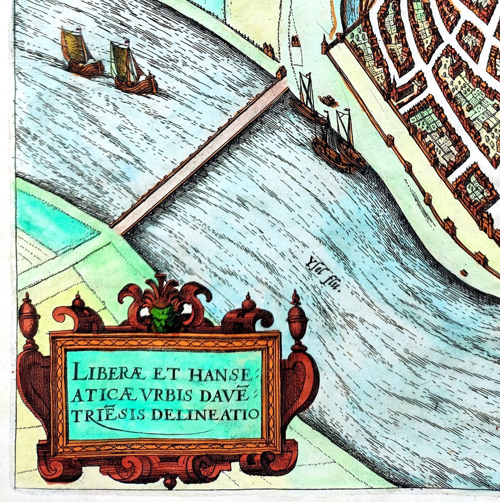
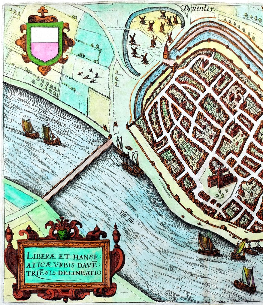
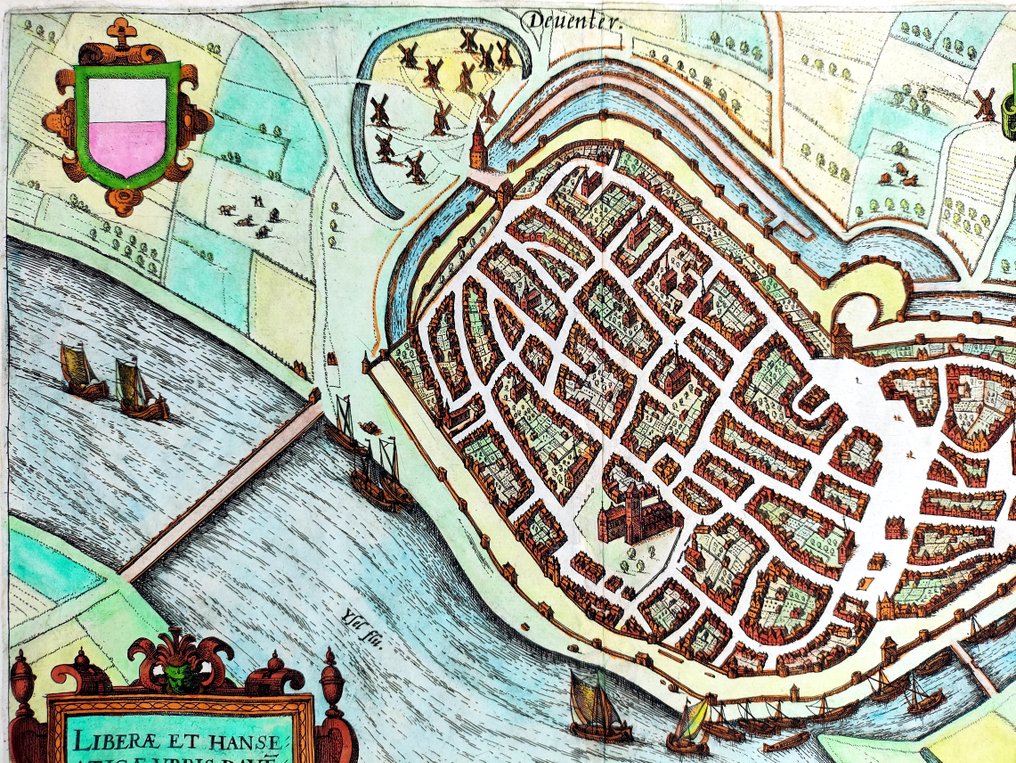
Copper-engraved, hand-coloured map titled Davetriesis (Deventer) by Lodovico Guicciardini, published in Antwerp in 1588, depicting the City of Deventer in the Netherlands at 350 x 425 mm, in good condition and including a Certificate of Authenticity.
AI-assisted summary
Description from the seller
DECORATIVE MAP OF NETHERLANDS, CITY OF DEVENTER, OVERIJSEEL, HOLLAND, EUROPE, by Lodovico Guicciardini (1521-1589) was an Italian writer from Florence who lived primarily in Antwerp from 1542 or earlier. This map was printed in 1588, by Christophe Plantin in Antwerp, Italian edition. PLEASE NOTE: the buyer will also receive a Certificate of Authenticity (COA). Original engraving, beautiful colours, very good condition, taken directly from the original volumes, with original margins, no particular cuts or defects to report, normal small imperfections due to time, laid paper with chain lines and watermark as per photo. To complete the documentation, the photo of the title of the work is also published with the name of the artists who created the prints.
This map is from the book “Descrittione di tutti i Paesi Bassi" (Description of all the Low Countries), and the most famed description of the whole Low Countries. The engravings were made by the following artists who worked for the Plantin studio at that time: Pieter van der Borcht the Elder (1530-1608); Abraham de Bruyn (1539-1587); Chrispijn van den Broeck (1523-1591); Antonij van Leest (1545-1592).
TITLE/DESCRIPTION: Liberae et hanseaticae urbis davetriesis delineato (Outline of the free and Hanseatic city of Deventer). Fine example of Lodovico Guicciardini's map and with decorative cartouches and printed in Antwerp, 1588, by Christophe Plantin (1520-1589). Sheet size: height 350 x width 425 mm (13.8 by 16.7 inches). Laid paper with chain lines and watermark and centre fold as published, original intact and wide margins, on the back remains of the original binding. The map is in very good condition, beautiful hand coloring (later), images and text intact, normal small imperfections due to time.
AUTHOR/CARTOGRAPHER: Lodovico Guicciardini (1521-1589) was an Italian writer and merchant from Florence who lived primarily in Antwerp from 1542 or earlier. He was the nephew of historian and diplomat Francesco Guicciardini. His best-known work, the Descrittione di Lodovico Guicciardini patritio fiorentino di tutti i Paesi Bassi altrimenti detti Germania inferiore (Description of the Low Countries), was an influential account of the history and the arts of the Low Countries, accompanied by city maps by various leading engravers. The work is a major source of information on the artists of the period. He died at 68 and is buried in the Antwerp Cathedral.
REFERENCES: Voet 1280; cf. Adams G-1542; Henk Deys ea, Guicciardini Illustratus. De kaarten en prenten in Lodovico Guicciardini’s "Beschrijving van de Nederlanden". Universiteit Utrecht/Hes & De Graaf Publishers, 2001; H. de la Fontaine Verwey, The history of Guicciardini's description of the Low Countries, in: Quaerendo XII (1982), pp. 22-51.
SHIPPING: via UPS, DHL, National Postal Services, protected, INSURED and fully tracked package. Estimated time for Europe 3-5 working days. Shipping within one working day, you can combine shipping if you purchases several items from us, saving money and time.
Details
Era
1400-1900
Number of items
1
Country
Netherlands
Geographical specification
City Of Deventer, Overijseel, Holland, Europe
Map maker/ publisher
Lodovico Guicciardini
Map/ Book title
Davetriesis (Deventer)
Period
1581-1600
Condition
Good
Technique
Copper engraving
Additional Information
Hand Colored Map
Map colour
Contemporary hand colour
Height
350 mm
Width
425 mm
Sold by
