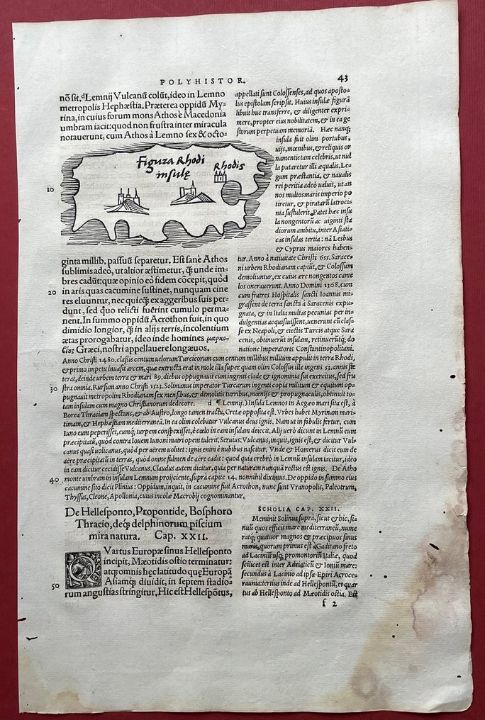
Greece - Rhodes Island; Sebastian Münster / Solinus - Figura Rhodi insulae (Shape of Rhodus Island) - 1521-1550


00
days
20
hours
53
minutes
21
seconds
Starting bid
€ 1
Reserve price not met

Expert
Selected by Ilaria Colombo
Specialist in old books, specialising in theological disputes since 1999.
Estimate € 150 - € 200
No bids placed
Catawiki Buyer Protection
Your payment’s safe with us until you receive your object.View details
Trustpilot 4.4 | 122630 reviews
Rated Excellent on Trustpilot.
Figura Rhodi insulae, a wood‑cut map by Sebastian Münster (Solinus) of Rhodes Island, Greece, dating from 1521–1550 and uncoloured, noted as the oldest printed map of Rhodes (dated 1538/1543).
AI-assisted summary
Description from the seller
THE OLDEST PRINTED MAP OF THE ISLAND OF RHODES with WEST at the top. The old natural harbor of Rhodes Town is indicated as" Rhodis" on the map, with a fortress close by.
Drawn in 1538 by Sebastian Münster after Pomponius Mela, a Roman geographer in the first century AD., here in the second and last edition of 1543, which seems to be rarer than the first edition of 1538.
Printed on a full text page from: G.Iulius Solinus and Pomponius Mela C. IVLII SOLINI POLYHISTOR... Published in Basel by Michael Isingrin, 1543.
Net size of the map: 8.5 x 13.2cm. Full sheet with Latin text. 20 x 31.5cm.
This RARE and unusual early wood block map predates the better known Rhodes map by Benedetto Bordone of 1547, which was clearly inspired by this Ptolemaic Münster miniature map, as its similar shape and orientation towards West indicates.
Some age toning and damp stains on right bottom margins (not affecting the map itself), a few old worm holes and trails in the margins, none within the map.
Verso printed by Latin text.
(shipping with registered airmail, arrival time 10 -30 days, depending on destination). To Italy we ship with EMS courier.
Seller's Story
M.POLLAK ANTIQUARIAT founded in 1899 and now in its third generation, is owned and managed by Malka and Cornel Pollak. We specialize in antiquarian and out-of-prints books on the history of the HOLY LAND and the Middle East., as well as original antique maps and prints of this area. We deal with rare art books and bibliophile editions, Jewish history and German literature before WW2.
WE ARE THE ONLY MEMBERS IN ISRAEL of "THE ANTIQUARIAN BOOKSELLERS' ASSOCIATION ABA” (ILAB) and the "Verband deutscher Antiquare". WE RUN TWO STORES IN TEL-AVIV at 36 & 42 King George Street.
With great passion and devotion we personally consult our customers world-wide.
Translated by Google TranslateTHE OLDEST PRINTED MAP OF THE ISLAND OF RHODES with WEST at the top. The old natural harbor of Rhodes Town is indicated as" Rhodis" on the map, with a fortress close by.
Drawn in 1538 by Sebastian Münster after Pomponius Mela, a Roman geographer in the first century AD., here in the second and last edition of 1543, which seems to be rarer than the first edition of 1538.
Printed on a full text page from: G.Iulius Solinus and Pomponius Mela C. IVLII SOLINI POLYHISTOR... Published in Basel by Michael Isingrin, 1543.
Net size of the map: 8.5 x 13.2cm. Full sheet with Latin text. 20 x 31.5cm.
This RARE and unusual early wood block map predates the better known Rhodes map by Benedetto Bordone of 1547, which was clearly inspired by this Ptolemaic Münster miniature map, as its similar shape and orientation towards West indicates.
Some age toning and damp stains on right bottom margins (not affecting the map itself), a few old worm holes and trails in the margins, none within the map.
Verso printed by Latin text.
(shipping with registered airmail, arrival time 10 -30 days, depending on destination). To Italy we ship with EMS courier.
Seller's Story
M.POLLAK ANTIQUARIAT founded in 1899 and now in its third generation, is owned and managed by Malka and Cornel Pollak. We specialize in antiquarian and out-of-prints books on the history of the HOLY LAND and the Middle East., as well as original antique maps and prints of this area. We deal with rare art books and bibliophile editions, Jewish history and German literature before WW2.
WE ARE THE ONLY MEMBERS IN ISRAEL of "THE ANTIQUARIAN BOOKSELLERS' ASSOCIATION ABA” (ILAB) and the "Verband deutscher Antiquare". WE RUN TWO STORES IN TEL-AVIV at 36 & 42 King George Street.
With great passion and devotion we personally consult our customers world-wide.
Translated by Google TranslateDetails
Era
1400-1900
Number of items
1
Country
Greece
Geographical specification
Rhodes Island
Map maker/ publisher
Sebastian Münster / Solinus
Map/ Book title
Figura Rhodi insulae (Shape of Rhodus Island)
Period
1521-1550
Condition
Good
Technique
Wood cut
Additional Information
THE OLDEST PRINTED MAP OF RHODOS- dated 1538/1543
Map colour
Uncoloured map
Height
5 cm
Width
10 cm
