P.Moullart-Sanson / P.Duval - Introduction a la Geographie / La Chronologie en plusieurs Tables - 1677-1705


Opens 11:00
Starting bid
€ 1
Add to your favourites to get an alert when the auction starts.

Catawiki Buyer Protection
Your payment’s safe with us until you receive your object.View details
Trustpilot 4.4 | 122813 reviews
Rated Excellent on Trustpilot.
Description from the seller
Sorry no shipping to the USA, due to local post not accepting shipments to the US
2 Atlas of 1705 and 1677, by Sanson with some plates [incomplete], and by Duval - mostly engraved [fragment]
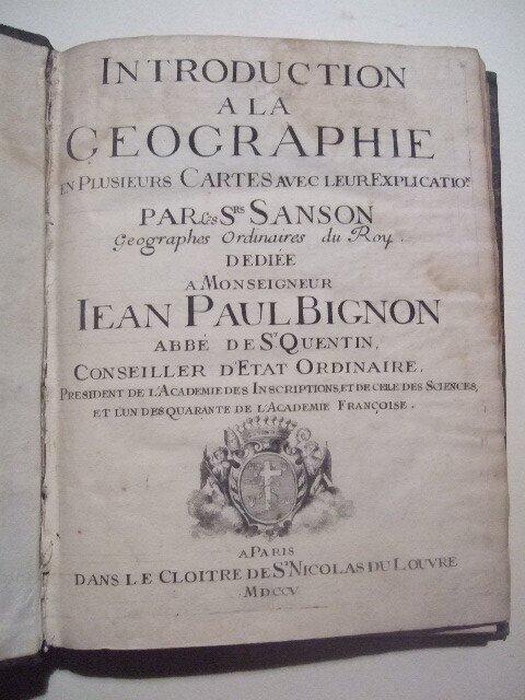
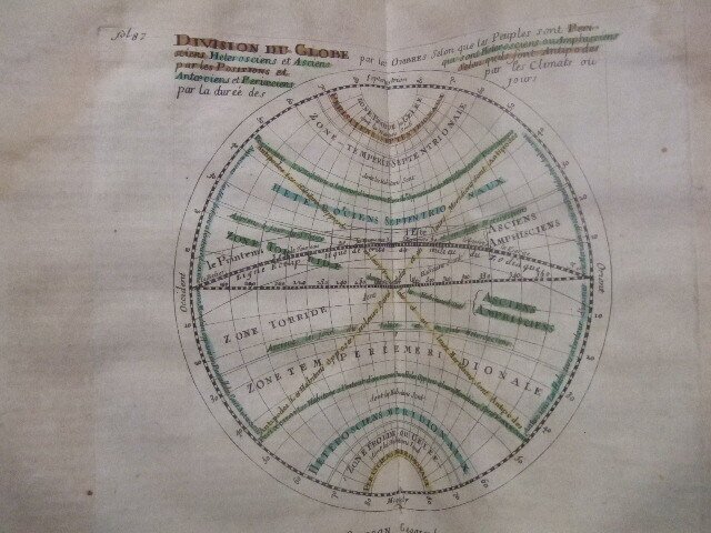
1] The Atlas by Sanson-Moullart 'Introduction a la Geographie' with complete text in original paper on carton binding, with 4 copper engraved, old-colored plates .
7ff+239 pages, with waterstains mostly in upper part, little foxing and browning by age, missing some maps/plates, remaining only four [all photographed]
joined with
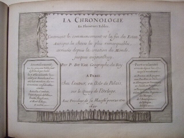
2] 1677, Atlas Fragment by Pierre Duval - most pages are engraved !, with still complete sections - 'Lettres des Nombres chez les Romains' engraved [Roman number and names system], - text of 'Parallele de l'ancienne & de nouvelle Geographie' Typography [Location and Translation of ancient/latin place names into modern - for his time], - with engr. title page, 'La Chronologie en plusiers Tables ..',all engraved, [Parallel chronological tables for several Countries and Regions ,starting at Year Zero - Creation of the World by God, up to 1674
with annex of 2 sheets, names of the Sovereign Princes in Europe. all pages copperengraved,
altogether 30 sheets , in generally good condition - some old annotations , occasional foxing, and little browning of paper by age [mostly in margins] - original of its time binding with spine missing
shipping by registered mail only [weight 1.3 kg]
SANSON FAMILY
Nicolas Sanson (1600-1667) - Guillaume Sanson (1633-1703) - Pierre Moullart-Sanson (? -1730)
Originally from Abbeville, Nicolas I Sanson showed a keen interest in historical geography. He was still very young; he published a map of ancient Gaul and two treatises, Britannia and Portus Itius on Abbeville and Boulogne's origins. His meeting with Melchior Tavernier was decisive: it prompted him to give up his duties as a military engineer in Picardy and devote himself to engraved cartography.
At the same time, Sanson had drawn up the outline of modern France. He got the help of Tavernier, who encouraged him to compete with the Dutch map publishers. Tavernier contacted other French cartographers whose works he published.
From 1643, N. Sanson obtained a privilege to publish a work personally, the Princes souverains de l'Italie. Then, in 1644 and 1645, he had his famous geographical tables printed, which significantly contributed to his fame. He also published a series of atlases in quarto of the four continents.
In 1648, N. Sanson associated himself with Mariette to publish atlases. From then on, specific maps bore his name and others Mariette's. N. Sanson and Mariette worked together for more than 20 years. After the death of N. Sanson, Mariette acquired the entire fund. Since Mariette only wanted to publish complete atlases, individual maps were no longer sold, and some army generals complained to the king.
The disagreement between the Sanson family and Pierre II Mariette culminated in 1671 when Guillaume Sanson took the case to court. There was no longer any question of collaboration: Guillaume Sanson started working for another publisher, Alexis-Hubert Jaillot.
The Sanson family faced financial difficulties, and in 1692, their cousin, Pierre Moullart-Sanson, bought the entire geographic fund from his uncles and aunt. Pierre Moullart-Sanson was the son of Françoise Sanson (third child of Nicolas) and Pierre Moullart. He restarted the publishing of Sanson's world atlas, and in 1704 he acquired a privilege for publishing all the works of Nicolas and Guillaume Sanson, which continued to be published until 1730.
Pierre Du Val (1619-1683)
was one of the most influential and prolific mapmakers and publishers working in Paris in the third quarter of the seventeenth century. He was the nephew of Nicolas Sanson, the leading French mapmaker of the period, and Geographer to the King of France from 1650. He was also responsible for providing maps for other Parisian editors of the period; Jollain, de Fer and Berey amongst others.
The early years of Du Val's career were devoted to his atlas projects, while later in his career he was to concentrate on separately published, and often multi-sheet, maps. His first atlas was the "Cartes Geographiques Methodiquement Divisees" published in 1654. This contained only a few of Du Val's own maps with the others comprising those of Sanson, Briet, Boisseau and even those of the earlier Dutch mapmakers, Mercator, Blaeu, Hondius and Jansson.
The atlas was re-issued in 1655 and 1667, and the title was altered to "Cartes De Geographie Les Plus Nouvelles Et Les Plus Fideles".
These later issues contained more of Du Val's own maps but were still very much supplemented by the maps of other makers.
Du Val also specialized in producing parlour games, games designed to teach geography and even snakes and ladders! Small-sized works also formed part of his output as did geographical tables, genealogies and chronologies.
Other early works by Du Val included: La Geographie Francoise, La Geographie Universelle, Cartes Pours Les Itineraires and Cartes Des Provinces Eschues à La Reine, amongst others.
Du Val died in 1683, and the business was continued first by his widow Marie Desmaretz, and then by his daughters
Sorry no shipping to the USA, due to local post not accepting shipments to the US
2 Atlas of 1705 and 1677, by Sanson with some plates [incomplete], and by Duval - mostly engraved [fragment]
1] The Atlas by Sanson-Moullart 'Introduction a la Geographie' with complete text in original paper on carton binding, with 4 copper engraved, old-colored plates .
7ff+239 pages, with waterstains mostly in upper part, little foxing and browning by age, missing some maps/plates, remaining only four [all photographed]
joined with
2] 1677, Atlas Fragment by Pierre Duval - most pages are engraved !, with still complete sections - 'Lettres des Nombres chez les Romains' engraved [Roman number and names system], - text of 'Parallele de l'ancienne & de nouvelle Geographie' Typography [Location and Translation of ancient/latin place names into modern - for his time], - with engr. title page, 'La Chronologie en plusiers Tables ..',all engraved, [Parallel chronological tables for several Countries and Regions ,starting at Year Zero - Creation of the World by God, up to 1674
with annex of 2 sheets, names of the Sovereign Princes in Europe. all pages copperengraved,
altogether 30 sheets , in generally good condition - some old annotations , occasional foxing, and little browning of paper by age [mostly in margins] - original of its time binding with spine missing
shipping by registered mail only [weight 1.3 kg]
SANSON FAMILY
Nicolas Sanson (1600-1667) - Guillaume Sanson (1633-1703) - Pierre Moullart-Sanson (? -1730)
Originally from Abbeville, Nicolas I Sanson showed a keen interest in historical geography. He was still very young; he published a map of ancient Gaul and two treatises, Britannia and Portus Itius on Abbeville and Boulogne's origins. His meeting with Melchior Tavernier was decisive: it prompted him to give up his duties as a military engineer in Picardy and devote himself to engraved cartography.
At the same time, Sanson had drawn up the outline of modern France. He got the help of Tavernier, who encouraged him to compete with the Dutch map publishers. Tavernier contacted other French cartographers whose works he published.
From 1643, N. Sanson obtained a privilege to publish a work personally, the Princes souverains de l'Italie. Then, in 1644 and 1645, he had his famous geographical tables printed, which significantly contributed to his fame. He also published a series of atlases in quarto of the four continents.
In 1648, N. Sanson associated himself with Mariette to publish atlases. From then on, specific maps bore his name and others Mariette's. N. Sanson and Mariette worked together for more than 20 years. After the death of N. Sanson, Mariette acquired the entire fund. Since Mariette only wanted to publish complete atlases, individual maps were no longer sold, and some army generals complained to the king.
The disagreement between the Sanson family and Pierre II Mariette culminated in 1671 when Guillaume Sanson took the case to court. There was no longer any question of collaboration: Guillaume Sanson started working for another publisher, Alexis-Hubert Jaillot.
The Sanson family faced financial difficulties, and in 1692, their cousin, Pierre Moullart-Sanson, bought the entire geographic fund from his uncles and aunt. Pierre Moullart-Sanson was the son of Françoise Sanson (third child of Nicolas) and Pierre Moullart. He restarted the publishing of Sanson's world atlas, and in 1704 he acquired a privilege for publishing all the works of Nicolas and Guillaume Sanson, which continued to be published until 1730.
Pierre Du Val (1619-1683)
was one of the most influential and prolific mapmakers and publishers working in Paris in the third quarter of the seventeenth century. He was the nephew of Nicolas Sanson, the leading French mapmaker of the period, and Geographer to the King of France from 1650. He was also responsible for providing maps for other Parisian editors of the period; Jollain, de Fer and Berey amongst others.
The early years of Du Val's career were devoted to his atlas projects, while later in his career he was to concentrate on separately published, and often multi-sheet, maps. His first atlas was the "Cartes Geographiques Methodiquement Divisees" published in 1654. This contained only a few of Du Val's own maps with the others comprising those of Sanson, Briet, Boisseau and even those of the earlier Dutch mapmakers, Mercator, Blaeu, Hondius and Jansson.
The atlas was re-issued in 1655 and 1667, and the title was altered to "Cartes De Geographie Les Plus Nouvelles Et Les Plus Fideles".
These later issues contained more of Du Val's own maps but were still very much supplemented by the maps of other makers.
Du Val also specialized in producing parlour games, games designed to teach geography and even snakes and ladders! Small-sized works also formed part of his output as did geographical tables, genealogies and chronologies.
Other early works by Du Val included: La Geographie Francoise, La Geographie Universelle, Cartes Pours Les Itineraires and Cartes Des Provinces Eschues à La Reine, amongst others.
Du Val died in 1683, and the business was continued first by his widow Marie Desmaretz, and then by his daughters
Details
Number of Books
2
Subject
Geography
Book Title
Introduction a la Geographie / La Chronologie en plusieurs Tables
Author/ Illustrator
P.Moullart-Sanson / P.Duval
Condition
Poor
Publication year oldest item
1677
Publication year youngest item
1705
Height
260 mm
Edition
1st Edition
Width
200 mm
Language
French
Original language
Yes
Number of pages
253
Sold by
