Partial: M. Z. - Topographiae sive Descriptionis Galliae - 1657


00
days
15
hours
39
minutes
03
seconds
Current bid
€ 45
No reserve price

Expert
Selected by Volker Riepenhausen
Specialist in travel literature and pre-1600 rare prints with 28 years experience.
Estimate € 800 - € 1,200
34 other people are watching this object
 Bidder 2631 Bidder 2631 | €45 | |
|---|---|---|
 Bidder 1148 Bidder 1148 | €40 | |
| Bidder 2723 | €33 | |
Catawiki Buyer Protection
Your payment’s safe with us until you receive your object.View details
Trustpilot 4.4 | 121798 reviews
Rated Excellent on Trustpilot.
Topographiae sive Descriptionis Galliae, attributed to M. Z., is an illustrated 1657 Latin edition published by Apud Casparum Merianum in Pelle binding, comprising 24 pages with an index and seven double-page plates.
AI-assisted summary
Description from the seller
Elegitur presents exclusively: Topography of Gaul – Part VI: Provinces of Berry, Auvergne & Limousin
Frankfurt, at Caspar Merian, 1657
The input is a dash character, which does not require translation.
The work and its editorial context
The volume belongs to the monumental series of the Topographia, one of the most extensive publishing enterprises of the 17th century, the result of collaboration between the geographer Martin Zeiller (1589–1661) and the famous copperplate workshop of the Merian family in Frankfurt. The series, comprising over thirty volumes published between 1640 and 1688, represents one of the most ambitious syntheses of chorographic geography, urban iconography, and antiquarian description produced in the modern age.
This Part VI, dedicated to the provinces of Berry, Auvergne, and Limousin, was published in 1657 by Caspar Merian (1627–1686), son and successor of the great Swiss engraver Matthäus Merian the Elder (1593–1650). Caspar continued his work with philological discipline and extraordinarily high graphic quality, helping to give Merian's production an almost 'encyclopedic' character, a precursor to modern dissemination.
The input is a dash character, which does not require translation.
The author: Martin Zeiller
Zeiller, a German scholar with a humanistic background, was one of the most prolific geographical compilers of his time. His works are set in an era when descriptive geography, combining direct observation, travel information, antiquarian erudition, and cartographic arrangement, became a fundamental tool for political and economic knowledge for European states.
His writing, in elegant and clear Latin, combines topography, local history, political news, and descriptions of customs, following the model of Renaissance chorography but expanding it towards a proto-statist perspective.
The input is a dash character, which does not require translation.
The storyboards and the illustrators.
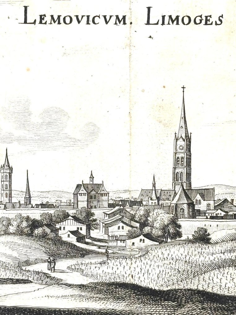
The heart of the Topographia is made up of copperplate engravings, the true hallmark of the Merian workshop. The city views and representations of castles, monasteries, walled towns, and agricultural landscapes of Berry, Auvergne, and Limousin were mostly engraved by Matthäus Merian the Elder in the years prior to his death and completed by:
Caspar Merian
Matthäus Merian the Younger (1621–1687)
Some anonymous collaborators at the Frankfurt atelier, specialized in perspective views.
The plates – about fifty in the volume – combine surprisingly precise cartography with refined pictorial rendering. The use of the 'bird's-eye view' and architectural perspective makes them today invaluable testimonies of pre-revolutionary French urban planning.
The input is a dash character, which does not require translation.
The title page
The magnificent engraver's frontispiece, rich in monarchical symbolism, encloses the text within a royal crown surrounded by the collar of the Order of the Holy Spirit – the highest distinction of the French monarchy – supported by palms and allegorical ribbons.
This iconography is not purely ornamental: it reaffirms France's centrality as a European power and the desire to represent it in all its geographical grandeur.
The input is a dash character, which does not require translation.
The cultural significance and impact of the work.
Published during the reign of Louis XIV, in a Europe still marked by the Thirty Years' War, the Topographia Galliae assumes a significance that transcends mere description of places. It is a tool of:
State knowledge, useful to merchants, diplomats, and administrators.
Cultural promotion, as it offers an orderly and glorious image of France.
Preservation of memory, providing representations of cities and territories that are now drastically changed.
It is no coincidence that works from this series were owned by princely libraries, such as that of the Duke of Orléans, and that they were consulted by educated travelers, scientists, military officers, and cartographers.
The input is a dash character, which does not require translation.
Connections with historical events and figures.
The dissemination of the Topographia was facilitated by the expansion of German printing in the second Seicento and by the increasing mobility of European intellectuals. Among the users and citers of the work, the following are remembered:
Gottfried Wilhelm Leibniz, who consulted various Merian series for his diplomatic studies.
Jean-Baptiste Colbert, the minister of Louis XIV, who promoted territorial description work in a similar spirit.
The real engineers of the Sun King, including Vauban, for whom views of French cities were considered useful references.
It is known an anecdote reported in contemporary correspondence: some Dutch travelers, surprised by the fidelity of Merian's views, carried the volumes with them to better recognize French cities along the way, as a sort of portable atlas pre-literate.
The input is a dash character, which does not require translation.
Conclusion
The Topographia Galliae – Pars VI is a masterpiece that combines erudite rigor, iconographic splendor, and fine etching skill. The work not only testifies to the mastery of Merian but also to the birth of a new culture of territorial representation in the heart of modern Europe.
It is, in effect, a cartographic symphony of the 17th century: austere, solemn, scientifically ambitious, and artistically sumptuous. A book that is not merely leafed through but contemplated.
Collation and state of preservation
Excellent preservation state, the collation is as follows: 24 pages numbered, 3 pages unnumbered forming the index, and inside are the magnificent 7 double-page folded plates.
Elegitur presents exclusively: Topography of Gaul – Part VI: Provinces of Berry, Auvergne & Limousin
Frankfurt, at Caspar Merian, 1657
The input is a dash character, which does not require translation.
The work and its editorial context
The volume belongs to the monumental series of the Topographia, one of the most extensive publishing enterprises of the 17th century, the result of collaboration between the geographer Martin Zeiller (1589–1661) and the famous copperplate workshop of the Merian family in Frankfurt. The series, comprising over thirty volumes published between 1640 and 1688, represents one of the most ambitious syntheses of chorographic geography, urban iconography, and antiquarian description produced in the modern age.
This Part VI, dedicated to the provinces of Berry, Auvergne, and Limousin, was published in 1657 by Caspar Merian (1627–1686), son and successor of the great Swiss engraver Matthäus Merian the Elder (1593–1650). Caspar continued his work with philological discipline and extraordinarily high graphic quality, helping to give Merian's production an almost 'encyclopedic' character, a precursor to modern dissemination.
The input is a dash character, which does not require translation.
The author: Martin Zeiller
Zeiller, a German scholar with a humanistic background, was one of the most prolific geographical compilers of his time. His works are set in an era when descriptive geography, combining direct observation, travel information, antiquarian erudition, and cartographic arrangement, became a fundamental tool for political and economic knowledge for European states.
His writing, in elegant and clear Latin, combines topography, local history, political news, and descriptions of customs, following the model of Renaissance chorography but expanding it towards a proto-statist perspective.
The input is a dash character, which does not require translation.
The storyboards and the illustrators.
The heart of the Topographia is made up of copperplate engravings, the true hallmark of the Merian workshop. The city views and representations of castles, monasteries, walled towns, and agricultural landscapes of Berry, Auvergne, and Limousin were mostly engraved by Matthäus Merian the Elder in the years prior to his death and completed by:
Caspar Merian
Matthäus Merian the Younger (1621–1687)
Some anonymous collaborators at the Frankfurt atelier, specialized in perspective views.
The plates – about fifty in the volume – combine surprisingly precise cartography with refined pictorial rendering. The use of the 'bird's-eye view' and architectural perspective makes them today invaluable testimonies of pre-revolutionary French urban planning.
The input is a dash character, which does not require translation.
The title page
The magnificent engraver's frontispiece, rich in monarchical symbolism, encloses the text within a royal crown surrounded by the collar of the Order of the Holy Spirit – the highest distinction of the French monarchy – supported by palms and allegorical ribbons.
This iconography is not purely ornamental: it reaffirms France's centrality as a European power and the desire to represent it in all its geographical grandeur.
The input is a dash character, which does not require translation.
The cultural significance and impact of the work.
Published during the reign of Louis XIV, in a Europe still marked by the Thirty Years' War, the Topographia Galliae assumes a significance that transcends mere description of places. It is a tool of:
State knowledge, useful to merchants, diplomats, and administrators.
Cultural promotion, as it offers an orderly and glorious image of France.
Preservation of memory, providing representations of cities and territories that are now drastically changed.
It is no coincidence that works from this series were owned by princely libraries, such as that of the Duke of Orléans, and that they were consulted by educated travelers, scientists, military officers, and cartographers.
The input is a dash character, which does not require translation.
Connections with historical events and figures.
The dissemination of the Topographia was facilitated by the expansion of German printing in the second Seicento and by the increasing mobility of European intellectuals. Among the users and citers of the work, the following are remembered:
Gottfried Wilhelm Leibniz, who consulted various Merian series for his diplomatic studies.
Jean-Baptiste Colbert, the minister of Louis XIV, who promoted territorial description work in a similar spirit.
The real engineers of the Sun King, including Vauban, for whom views of French cities were considered useful references.
It is known an anecdote reported in contemporary correspondence: some Dutch travelers, surprised by the fidelity of Merian's views, carried the volumes with them to better recognize French cities along the way, as a sort of portable atlas pre-literate.
The input is a dash character, which does not require translation.
Conclusion
The Topographia Galliae – Pars VI is a masterpiece that combines erudite rigor, iconographic splendor, and fine etching skill. The work not only testifies to the mastery of Merian but also to the birth of a new culture of territorial representation in the heart of modern Europe.
It is, in effect, a cartographic symphony of the 17th century: austere, solemn, scientifically ambitious, and artistically sumptuous. A book that is not merely leafed through but contemplated.
Collation and state of preservation
Excellent preservation state, the collation is as follows: 24 pages numbered, 3 pages unnumbered forming the index, and inside are the magnificent 7 double-page folded plates.
Details
Number of Books
1
Subject
Cartography, Geography, History, Topography
Book Title
Topographiae sive Descriptionis Galliae
Author/ Illustrator
Partial: M. Z.
Condition
Fine
Publication year oldest item
1657
Edition
Illustrated Edition
Language
Latin
Original language
Yes
Publisher
Apud Casparum Merianum
Binding/ Material
Leather
Number of pages
24
