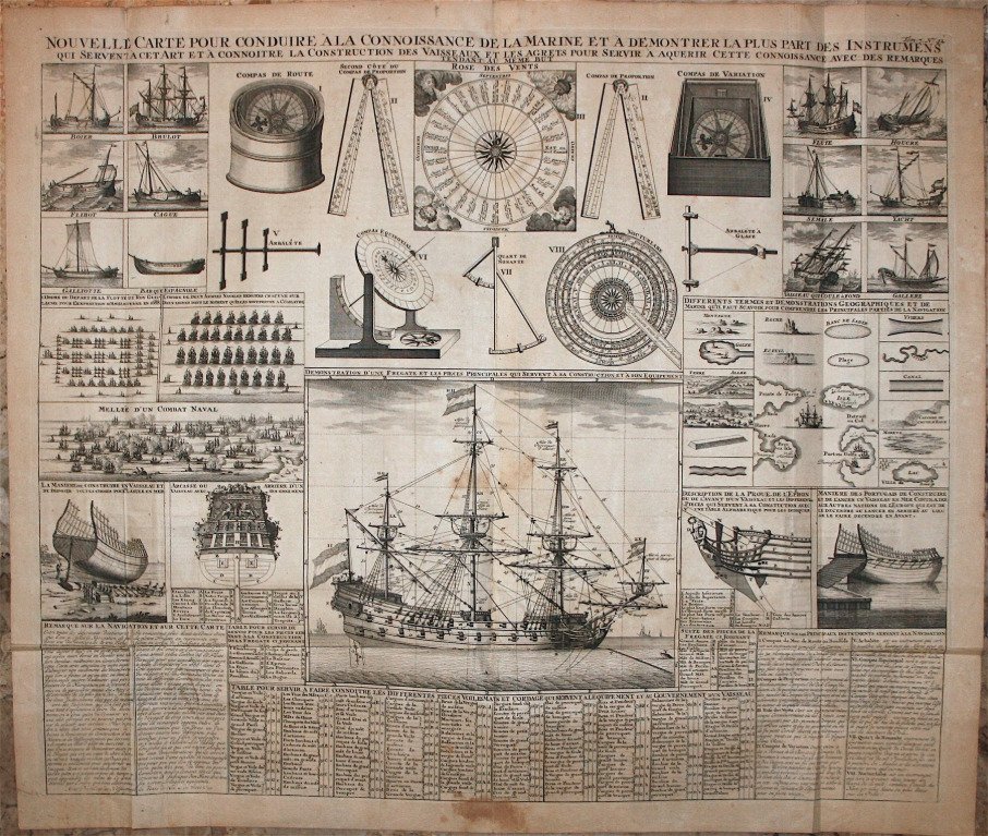
France - Paris; Chatelain - Nautical instruments and boats; Chatelain - Nouvelle Carte pour Conduire a la connoissance de la - 1701-1720

07
days
01
hour
11
minutes
05
seconds
Starting bid
€ 1
Reserve price not met
Zena Chiara Masud
Expert
Selected by Zena Chiara Masud

Holds a master’s degree in bibliography, with seven years of experience specialising in incunabula and Arabic manuscripts.

Estimate  € 300 - € 350
No bids placed

Catawiki Buyer Protection

Your payment’s safe with us until you receive your object.View details

Trustpilot 4.4 | 122385 reviews

Rated Excellent on Trustpilot.

Chatelain as author/editor presents Nautical instruments and boats; Chatelain - Nouvelle Carte pour Conduire a la connoissance de la Marine et a demontrer la plus part des Instrumens.

AI-assisted summary

Description from the seller

Nautical Instruments and Boats; Chatelain - New Map for Navigating Marine Knowledge and Demonstrating Most Instruments - 1707-14

Dimensions: 49 x 57.5 cm. (sheet: 53 x 62 cm.).

Condition: good. Water stains. Verse: in blank.

Recorder: Guedeville
Editor: Chatelain. Paris.
Note: from 'Atlas Historique...'

Details

Era
1400-1900
Number of items
1
Country
France
Geographical specification
Paris
Map maker/ publisher
Chatelain
Map/ Book title
Nautical instruments and boats; Chatelain - Nouvelle Carte pour Conduire a la connoissance de la
Period
1701-1720
Condition
Good
Additional Information
Nautical instruments and boats; Chatelain - New Map for Navigating to the Knowledge of
Map colour
Uncoloured map
Height
53 cm
Width
62 cm
Sold by
SpainVerified
6
Objects sold
Private

Similar objects

For you in

Books