Heinrich Glarean or Henricus Glareanus - De Geographia Liber (Book On Geography) - 1549


08
days
11
hours
33
minutes
23
seconds
Current bid
€ 550
Reserve price not met

Expert
Selected by Volker Riepenhausen
Specialist in travel literature and pre-1600 rare prints with 28 years experience.
Estimate € 1,100 - € 4,000
15 other people are watching this object
 Bidder 1594 Bidder 1594 | €550 | |
|---|---|---|
 Bidder 6616 Bidder 6616 | €500 |
Catawiki Buyer Protection
Your payment’s safe with us until you receive your object.View details
Trustpilot 4.4 | 122473 reviews
Rated Excellent on Trustpilot.
Heinrich Glarean’s illustrated Latin edition De Geographia Liber, a 1549 hand-coloured hardback of 78 pages, covering geography, astronomy, mathematics and related topics.
AI-assisted summary
Description from the seller
1549 EDITION OF ASTRONOMY, GEOGRAPHY, MATHEMATICS, METEOROLOGY, GEOMETRY, WEATHER, CARTOGRAPHY, GNOMONICS, SUNDIALS by Heinrich Glarean or Henricus Glareanus (1488-1563), a Swiss music theorist, humanist, geographer, mathematician, and cartographer. The book is entirely hand-colored with several dozen illustrations, graphs, initials, illustrating the universe, planets, five climate zones, winds, eclipses, astrolabes, sundials, solar apogee, the calculation of meridians, longitudes, sizes of the planets and their distances from the Earth, future positions and orbits of several planets, measuring time and light according to the seasons. It is one of the first books to describe the America, the islands of Dominican Republic, Hispaniola, Haiti, Cuba, and the recent discoveries of the "New World" by navigators Christopher Columbus and Amerigo Vespucci (leaf 38 as per attached photos). The book is in excellent condition with its antique binding, and detailed and intact color illustrations. No copies for sale, references; World Cat OCLC n°1343000037; USTC n°833582; Adams G-758 (1527 edition); ETH-Bibliothek Zürich, Rar 587, E-RARA n°11170; Stillwell 175 (1527 edition); Sabin 27537; European Americana 539/13 (1539 edition); Harrisse 228 (1539 edition); JCB Lib. cat., pre-1675; Iain Fenlon and Inga Mai Groote (eds.). Heinrich Glarean's Books: The Intellectual World of a Sixteenth-Century Musical Humanist, Cambridge and New York: Cambridge University Press, 2013.
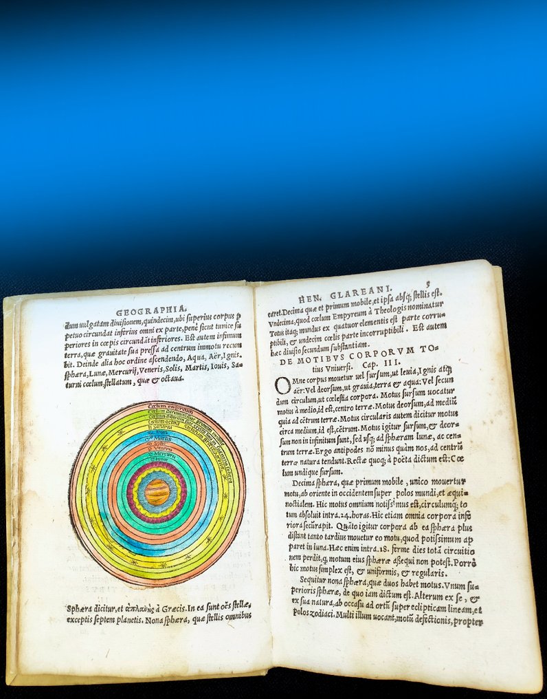
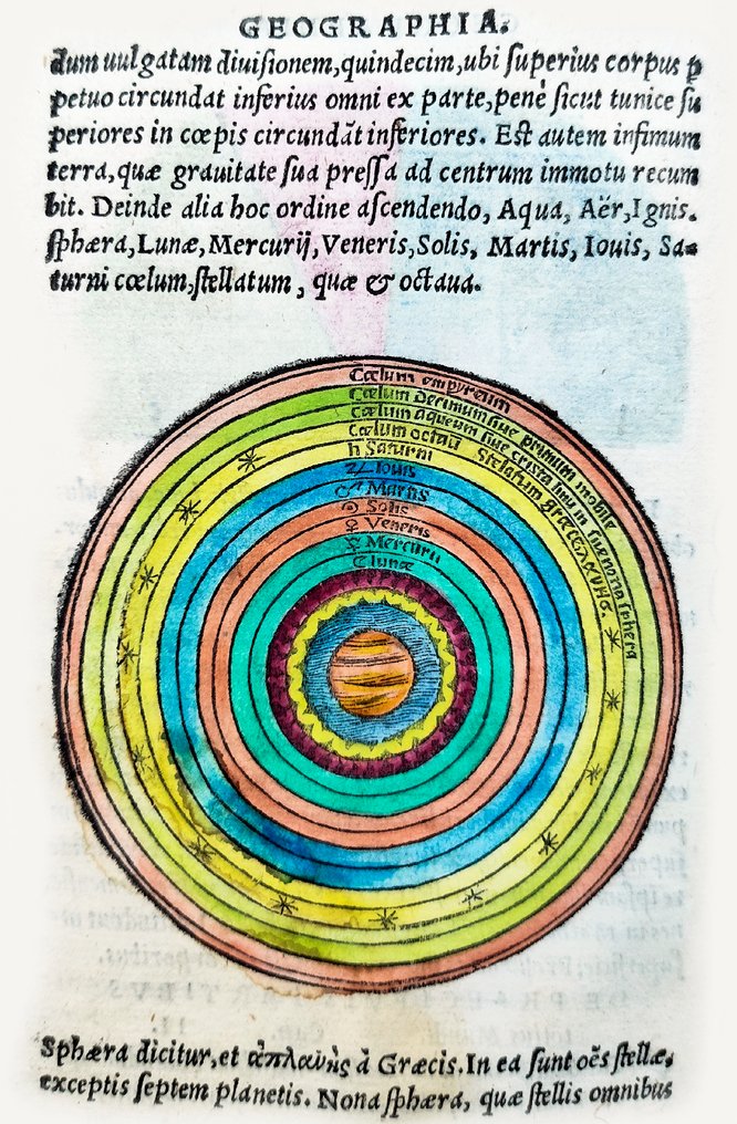
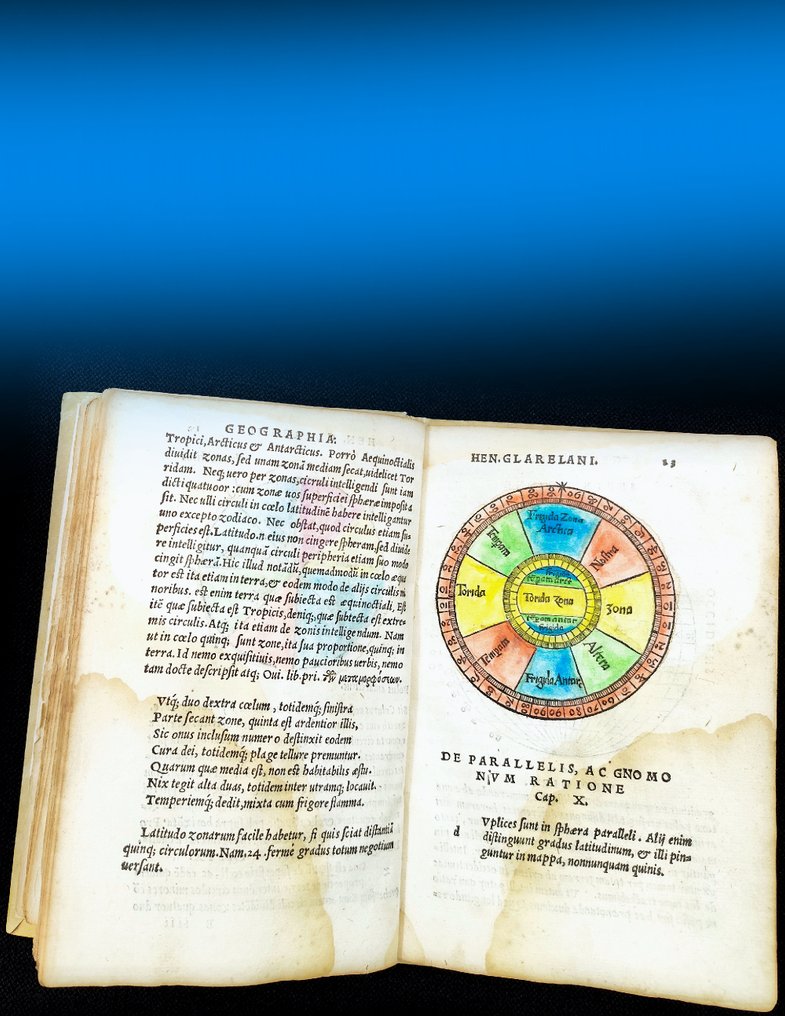
This book provides a representation of the universe derived from Ptolemy's system, with a spherical Earth at its center and concentric spheres surrounding it that support the celestial bodies. Eclipses are illustrated with diagrams. The author lays the foundations of mathematical geography and is the first to identify magnetic declination, the deviation of a compass needle from true north. Latitude and longitude are defined, and the effects of the sun's angle of incidence at different latitudes on climate are explained. The use of the astrolabe is described. This is followed by chapters on all the continents and regions of the world known at the time. It is one of the first books to describe America, the "New World", of the explorers Christopher Columbus and Amerigo Vespucci. GLAREAN SAYS VERBATIM: "To the west lies a land called America, situated at about eighty degrees of longitude. There are two islands, Spagnola and Isabella: these regions were explored along the coasts by the Spanish, with Christopher Columbus, a Genovese, and Amerigo Vespucci as leaders of the expedition." Glarean goes on to note that, according to some, these lands were already known at the time of the Emperor Augustus (63 BC–AD 14), and that they are mentioned in the sixth book of the Aeneid. Magnificent illustrations depicting science, astronomy, geography and mathematics from 500 years ago.
TITLE: De geographia liber unus ab ipso authore iam tertio recognitus (One book on geography, now revised for the third time by the author himself)
AUTHOR: Heinrich Glarean or Henricus Glareanus (1488-1563)
PUBLISHER: Melchiorre Sessa. On the last page or colophon: Venetijs apud Petrum, et Io. Mariam fratres, et Cornelium nepotem de Nicolinis de Sabio: ad instantiam Melchioris Sessae, 1549
DATE: 1549, third revised edition (Venice, at the instance of Peter, and John, brothers, and Cornelium, nephew of Nicolinis de Sabio: at the instance of Melchior Sessa, MDXLIX - 1549)
DESCRIPTION: In 8vo size, height 165 x width 113 mm (6.5 by 4.5 inches). Numbered leaves 39 (i.e. 78 pages), [1], complete book. Printer's trademark on the title page and at the end, publication date on the last page, italic text with numerous drawings, diagrams, and initials, all hand-colored. Pale but extensive water stain on the lower outer corner on several pages, otherwise text and images intact as per photo, rare and good copy. Old hardback parchment solid and in excellent condition. COMPLETE ILLUSTRATED EDITION.
AUTHOR: Heinrich Glarean or Henricus Glareanus (1488-1563) was a Swiss music theorist, humanist, geographer, mathematician, and cartographer. He was born in Mollis (in the canton of Glarus, hence his name), after a thorough early training in music, Glarean enrolled in the University of Cologne (Köln) in Germany, where he studied theology, philosophy, and mathematics as well as music. It was in Cologne where he held a poem as a tribute to Emperor Maximilian I. Since 1514 he was a teacher for Greek and Latin in Basel, where he met Erasmus and the two humanists became lifelong friends. He shortly was a lecturer at the University of Pavia in Italy for a few months in 1515, but returned to Basel due to the Battle of Marignano between Switzerland and France. In the early stages of the reformation, Glarean, like Erasmus, had considerable sympathy with Martin Luther's criticisms of church abuses and scholastic teaching methods. When the break with Rome became inevitable in 1521-1522, however, Glarean and Erasmus both remained faithful to the Church of Rome.
SHIPPING: via UPS, DHL, National Postal Services, protected, INSURED and fully tracked package. Estimated time for Europe 3-5 working days. Shipping within one working day, you can combine shipping if you purchases several items from us, saving money and time.
1549 EDITION OF ASTRONOMY, GEOGRAPHY, MATHEMATICS, METEOROLOGY, GEOMETRY, WEATHER, CARTOGRAPHY, GNOMONICS, SUNDIALS by Heinrich Glarean or Henricus Glareanus (1488-1563), a Swiss music theorist, humanist, geographer, mathematician, and cartographer. The book is entirely hand-colored with several dozen illustrations, graphs, initials, illustrating the universe, planets, five climate zones, winds, eclipses, astrolabes, sundials, solar apogee, the calculation of meridians, longitudes, sizes of the planets and their distances from the Earth, future positions and orbits of several planets, measuring time and light according to the seasons. It is one of the first books to describe the America, the islands of Dominican Republic, Hispaniola, Haiti, Cuba, and the recent discoveries of the "New World" by navigators Christopher Columbus and Amerigo Vespucci (leaf 38 as per attached photos). The book is in excellent condition with its antique binding, and detailed and intact color illustrations. No copies for sale, references; World Cat OCLC n°1343000037; USTC n°833582; Adams G-758 (1527 edition); ETH-Bibliothek Zürich, Rar 587, E-RARA n°11170; Stillwell 175 (1527 edition); Sabin 27537; European Americana 539/13 (1539 edition); Harrisse 228 (1539 edition); JCB Lib. cat., pre-1675; Iain Fenlon and Inga Mai Groote (eds.). Heinrich Glarean's Books: The Intellectual World of a Sixteenth-Century Musical Humanist, Cambridge and New York: Cambridge University Press, 2013.
This book provides a representation of the universe derived from Ptolemy's system, with a spherical Earth at its center and concentric spheres surrounding it that support the celestial bodies. Eclipses are illustrated with diagrams. The author lays the foundations of mathematical geography and is the first to identify magnetic declination, the deviation of a compass needle from true north. Latitude and longitude are defined, and the effects of the sun's angle of incidence at different latitudes on climate are explained. The use of the astrolabe is described. This is followed by chapters on all the continents and regions of the world known at the time. It is one of the first books to describe America, the "New World", of the explorers Christopher Columbus and Amerigo Vespucci. GLAREAN SAYS VERBATIM: "To the west lies a land called America, situated at about eighty degrees of longitude. There are two islands, Spagnola and Isabella: these regions were explored along the coasts by the Spanish, with Christopher Columbus, a Genovese, and Amerigo Vespucci as leaders of the expedition." Glarean goes on to note that, according to some, these lands were already known at the time of the Emperor Augustus (63 BC–AD 14), and that they are mentioned in the sixth book of the Aeneid. Magnificent illustrations depicting science, astronomy, geography and mathematics from 500 years ago.
TITLE: De geographia liber unus ab ipso authore iam tertio recognitus (One book on geography, now revised for the third time by the author himself)
AUTHOR: Heinrich Glarean or Henricus Glareanus (1488-1563)
PUBLISHER: Melchiorre Sessa. On the last page or colophon: Venetijs apud Petrum, et Io. Mariam fratres, et Cornelium nepotem de Nicolinis de Sabio: ad instantiam Melchioris Sessae, 1549
DATE: 1549, third revised edition (Venice, at the instance of Peter, and John, brothers, and Cornelium, nephew of Nicolinis de Sabio: at the instance of Melchior Sessa, MDXLIX - 1549)
DESCRIPTION: In 8vo size, height 165 x width 113 mm (6.5 by 4.5 inches). Numbered leaves 39 (i.e. 78 pages), [1], complete book. Printer's trademark on the title page and at the end, publication date on the last page, italic text with numerous drawings, diagrams, and initials, all hand-colored. Pale but extensive water stain on the lower outer corner on several pages, otherwise text and images intact as per photo, rare and good copy. Old hardback parchment solid and in excellent condition. COMPLETE ILLUSTRATED EDITION.
AUTHOR: Heinrich Glarean or Henricus Glareanus (1488-1563) was a Swiss music theorist, humanist, geographer, mathematician, and cartographer. He was born in Mollis (in the canton of Glarus, hence his name), after a thorough early training in music, Glarean enrolled in the University of Cologne (Köln) in Germany, where he studied theology, philosophy, and mathematics as well as music. It was in Cologne where he held a poem as a tribute to Emperor Maximilian I. Since 1514 he was a teacher for Greek and Latin in Basel, where he met Erasmus and the two humanists became lifelong friends. He shortly was a lecturer at the University of Pavia in Italy for a few months in 1515, but returned to Basel due to the Battle of Marignano between Switzerland and France. In the early stages of the reformation, Glarean, like Erasmus, had considerable sympathy with Martin Luther's criticisms of church abuses and scholastic teaching methods. When the break with Rome became inevitable in 1521-1522, however, Glarean and Erasmus both remained faithful to the Church of Rome.
SHIPPING: via UPS, DHL, National Postal Services, protected, INSURED and fully tracked package. Estimated time for Europe 3-5 working days. Shipping within one working day, you can combine shipping if you purchases several items from us, saving money and time.
Details
Number of Books
1
Subject
America, Archaeology, Art, Astrology, Astronomy, Cartography, Europe, Fine Bindings, Geography, History, Illustrated, Incunabula & early printing, Mathematics, Memorabilia, Nature, Outer space, Science, Ships and seafaring, Technology, Topography, Travels
Book Title
De Geographia Liber (Book On Geography)
Author/ Illustrator
Heinrich Glarean or Henricus Glareanus
Condition
Very good
Publication year oldest item
1549
Height
165 mm
Edition
Illustrated Edition, Revised edition
Width
113 mm
Language
Latin
Original language
Yes
Binding/ Material
Hardback
Extras
Hand coloured illustrations
Number of pages
78
Sold by
