Giulio Cesare - Caesaris Quae Extant - 1669

08
days
16
hours
09
minutes
46
seconds
Current bid
€ 35
Reserve price not met

Expert
Selected by Ilaria Colombo
Specialist in old books, specialising in theological disputes since 1999.
Estimate € 800 - € 1,200
13 other people are watching this object
 Bidder 8848 Bidder 8848 | €35 | |
|---|---|---|
| Bidder 3900 | €30 | |
| Bidder 3900 | €25 |
Catawiki Buyer Protection
Your payment’s safe with us until you receive your object.View details
Trustpilot 4.4 | 122473 reviews
Rated Excellent on Trustpilot.
Caesaris Quae Extant by C. Julius Caesar, illustrated edition of 1669 in Latin and Greek, published in Francofurtum by Ex Officina Zunneriana, with parchment binding, 1214 pages, three engraved maps and numerous woodcuts; a collector's copy.
AI-assisted summary
Description from the seller
Collector's copy - The complete works of Caesar, among maps, assaults, and worlds conquered
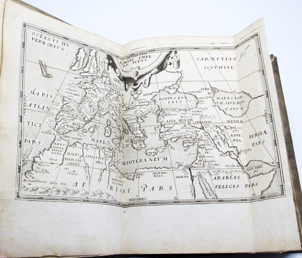
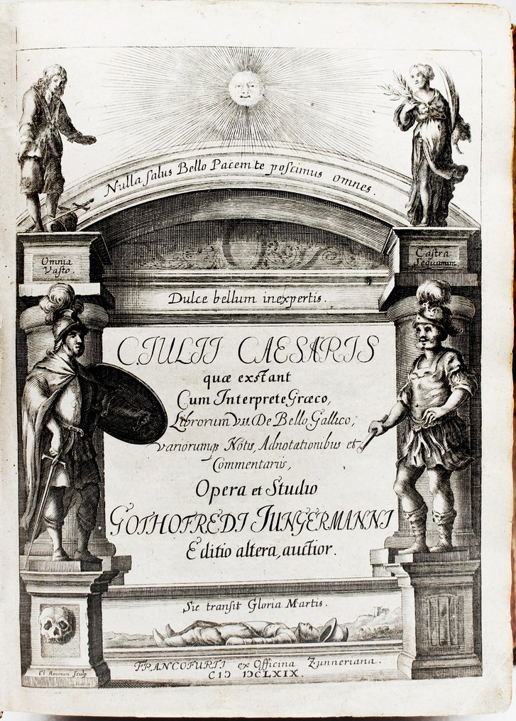
This monumental Frankfurt edition of 1669, produced by the prestigious Zunneriana workshop and curated by Gottfried Jungermann, represents one of the most ambitious seventeenth-century attempts to depict a total Caesar: historian, strategist, geographer, political symbol, and emblem of military discipline. The strength of the volume lies in its encyclopedic nature: maps of the Roman world, woodcuts of military instruments, representations of animals and peoples described in the Commentaries, critical apparatus in Latin and Greek, extensive indexes, and a visual layout that translates power into sign. The large plate of the Map of the Roman Empire, expanded across a double page, serves as a geographical summary of the conquest, while the engraved frontispiece places Caesar in a classical theater of glory and virtue. A copy that combines the aura of civic binding—bearing the arms of the city of Amsterdam—with the solidity of the text, and that retains the immediacy with which late Seicento Europe read Romanity as an imperial model.
Market value
The sixteenth-century illustrated editions of the Commentarii, in Latin and Greek, present a stable market thanks to their philological importance and the strong iconographic apparatus. Comparable copies, with intact maps and engraved frontispieces, generally range from 500 to 800 euros, with higher fluctuations for specimens with heraldic bindings or notable provenance. The presence of the three large engraved maps and numerous woodcuts in the text increases their value, as does the preservation of the binding in parchment with a civic coat of arms.
Physical description and condition - collector's copy
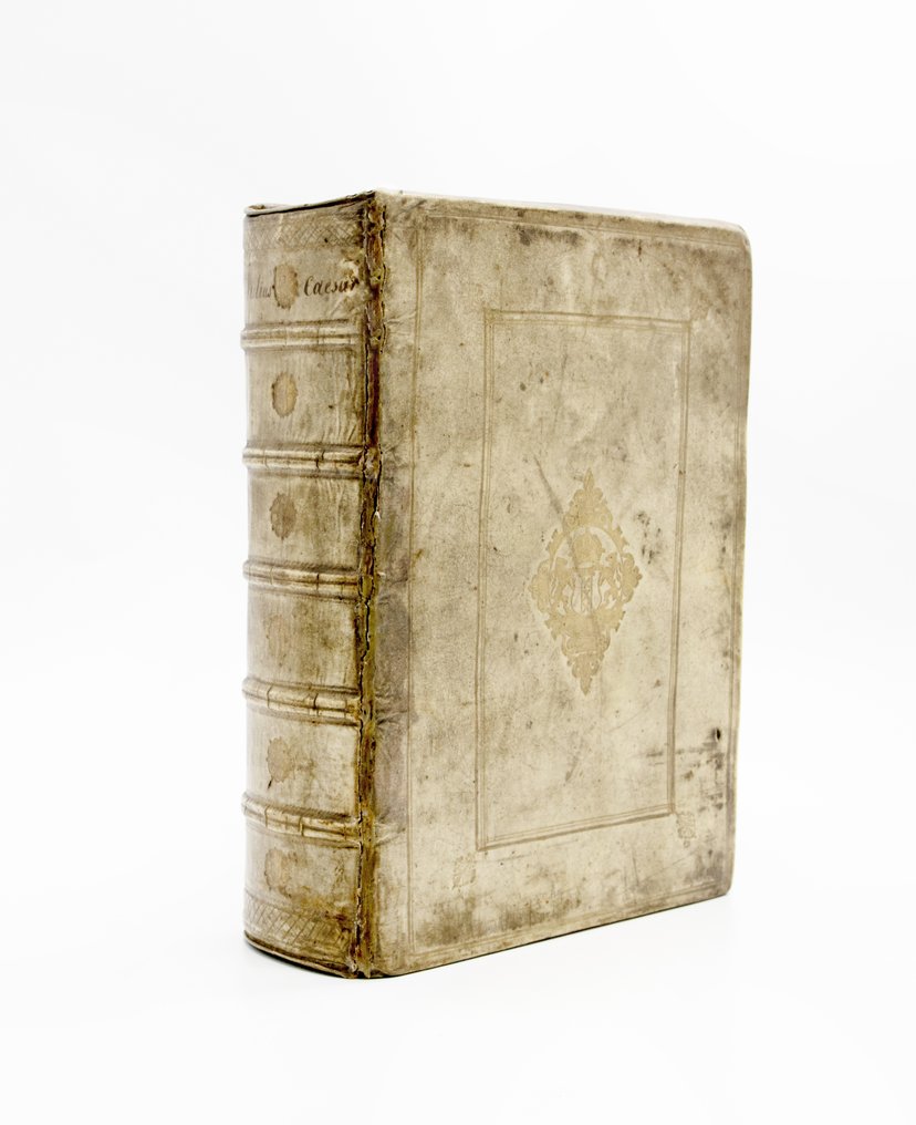
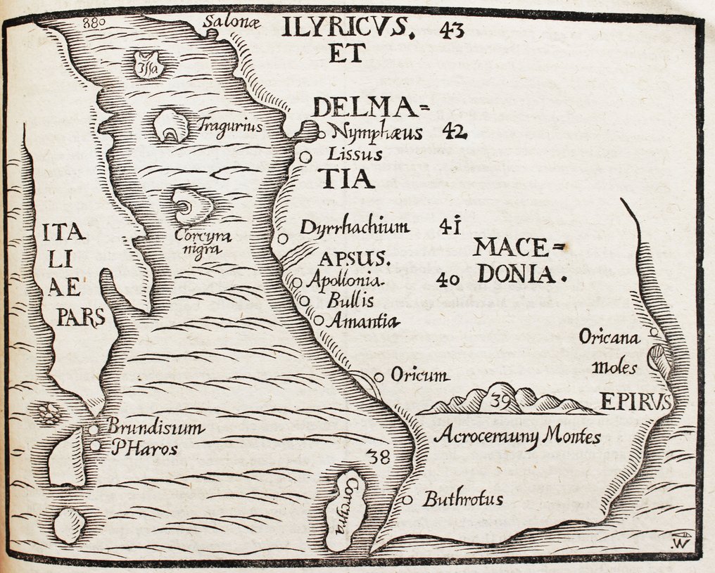
Contemporary binding in full parchment with arms of the city of Amsterdam at the center of the plate; spine with ribs and handwritten title, small stains and restorations at the joints. Frontispiece entirely engraved with allegorical figures and classical mottos. Three engraved maps, including a large double-page map of the Roman Empire Typus. Numerous woodcuts in the text: war machines, animals cited by Caesar, fortifications, military instruments. Text in Latin and Greek. Some browning. Pages (3); 26 unnumbered; 1048; 107; 24 unnumbered; (6). In ancient books, with a multi-century history, some imperfections may be present, not always noted in the description.
Full title and author
C. Julius Caesar's Works, including the Greek interpreter, Book VII of the Gallic War, with various notes, annotations, and commentaries.
Frankfurt, from the Zunnerian workshop, 1669
Gaius Julius Caesar
Context and Significance
This edition, extensively annotated and featuring a double column of text (Latin and Greek), belongs to the great philological era of the seventeenth century, when scholars aimed for a complete restoration of the classics. Jungermann's commentary, heir to the most rigorous German philology, renders Caesar's text an extremely advanced study tool. The maps are not mere embellishments: they constitute a scientific apparatus designed to visualize the operational theater of the Gallic campaigns. The woodcuts of war machines, bridges, fortified enclosures, as well as exotic animals cited by Caesar, build a technical and anthropological repertoire that transcended pure historiography, influencing treatises on military architecture and political geography of the seventeenth century. The Zunnerian imprint, known for the quality of the engravings and the clarity of the text, makes it one of the most solid editorial products of the era.
Biography of the Author
Gaius Julius Caesar (100–44 BC), military leader, politician, and author, is one of the pillars of Western culture. The Commentaries are not only military reports but narrative models and propaganda tools that establish a clear and authoritative language. Their influence extends from historiography to rhetoric, from pedagogy to political theory, up to modern military cartography.
Printing history and circulation
The Zunneriana workshop of Frankfurt was among the most esteemed of the seventeenth century for illustrated classical production. This second, 'auctior' edition by Jungermann incorporates additional materials, expanded notes, and a top-level cartographic apparatus. The print run was not large, and the presence of complete copies with all three maps is now significant. The binding with the Amsterdam coat of arms indicates an institutional or civic provenance, common in seventeenth-century Dutch libraries.
BIBLIOGRAPHY AND REFERENCES
Graesse II, 4
Schweiger, Handbook of Classical Bibliography I, 57
ESTC and USTC for localizations and variants
Brunet I, 1531
Dibdin, Introduction to the Classics
Oberhuber, Cartography and Military Representations in the Seventeenth Century
Catalogs: BnF, Bayerische Staatsbibliothek, Herzog August Bibliothek, WorldCat
Seller's Story
Luxury Books: Your Go-To Guide for Nabbing Literary Treasures!
Embarking on the thrilling journey of collecting rare and timeless printed works? Here's your snappy rundown, "The Collector's Cheat Sheet," to ensure you're not just flipping pages but stacking up the value:
1. Edition and Rarity: Rarity is the name of the game. First editions, limited printings, and books flaunting unique features like eye-catching illustrations or mind-blowing bindings? Consider them the VIPs of the collector's world.
2. Condition & Dimension: Picture this – a book in mint condition, untouched by the woes of wear and tear. Now, flip the script: wear, foxing, discoloration – they're the villains here. And don't forget to size up the dimensions, because a book's size matters in the collector's universe.
3. Authenticity: In a world of replicas and forgeries, verifying a book's authenticity is your superhero move. Expert examination and authentication – your trusty sidekicks in this quest.
4. Provenance: Who owned it before you? If the book has hobnobbed with famous figures or danced through historical events, its value skyrockets. Every book has a story, but some have blockbuster tales.
5. Demand and Market Trends: Think of book values as the stock market of the literary world. Stay savvy on collector trends and market shifts to ride the waves of value.
6. Subject Matter: Some topics are like fine wine – they get better with time. Dive into subjects with a timeless appeal or ride the wave of emerging cultural and historical relevance.
7. Binding and Design: Beauty is more than skin deep. Intricate bindings, stunning covers, and illustrations – these are the accessories that make a book runway-ready in the collector's eyes.
8. Association Copies: Books with a personal touch – whether it's a connection to the author or a famous personality – elevate the historical vibes. A book with a backstory? Count us in.
9. Investment Potential: Passion is the engine, but some collectors eye future returns. Keep in mind, though, that the book market can be as unpredictable as a plot twist.
10. Expert Advice: New to the game? Don't play solo. Seek wisdom from the book gurus, hit up book fairs, and join collector communities. We at Luxury Books are the Yodas of the rare book galaxy, helping you build collections that scream sophistication and cultural clout.
Because collecting rare books isn't just about dollar signs – it's a journey of preserving heritage and embracing literary treasures. Happy collecting!
Translated by Google TranslateCollector's copy - The complete works of Caesar, among maps, assaults, and worlds conquered
This monumental Frankfurt edition of 1669, produced by the prestigious Zunneriana workshop and curated by Gottfried Jungermann, represents one of the most ambitious seventeenth-century attempts to depict a total Caesar: historian, strategist, geographer, political symbol, and emblem of military discipline. The strength of the volume lies in its encyclopedic nature: maps of the Roman world, woodcuts of military instruments, representations of animals and peoples described in the Commentaries, critical apparatus in Latin and Greek, extensive indexes, and a visual layout that translates power into sign. The large plate of the Map of the Roman Empire, expanded across a double page, serves as a geographical summary of the conquest, while the engraved frontispiece places Caesar in a classical theater of glory and virtue. A copy that combines the aura of civic binding—bearing the arms of the city of Amsterdam—with the solidity of the text, and that retains the immediacy with which late Seicento Europe read Romanity as an imperial model.
Market value
The sixteenth-century illustrated editions of the Commentarii, in Latin and Greek, present a stable market thanks to their philological importance and the strong iconographic apparatus. Comparable copies, with intact maps and engraved frontispieces, generally range from 500 to 800 euros, with higher fluctuations for specimens with heraldic bindings or notable provenance. The presence of the three large engraved maps and numerous woodcuts in the text increases their value, as does the preservation of the binding in parchment with a civic coat of arms.
Physical description and condition - collector's copy
Contemporary binding in full parchment with arms of the city of Amsterdam at the center of the plate; spine with ribs and handwritten title, small stains and restorations at the joints. Frontispiece entirely engraved with allegorical figures and classical mottos. Three engraved maps, including a large double-page map of the Roman Empire Typus. Numerous woodcuts in the text: war machines, animals cited by Caesar, fortifications, military instruments. Text in Latin and Greek. Some browning. Pages (3); 26 unnumbered; 1048; 107; 24 unnumbered; (6). In ancient books, with a multi-century history, some imperfections may be present, not always noted in the description.
Full title and author
C. Julius Caesar's Works, including the Greek interpreter, Book VII of the Gallic War, with various notes, annotations, and commentaries.
Frankfurt, from the Zunnerian workshop, 1669
Gaius Julius Caesar
Context and Significance
This edition, extensively annotated and featuring a double column of text (Latin and Greek), belongs to the great philological era of the seventeenth century, when scholars aimed for a complete restoration of the classics. Jungermann's commentary, heir to the most rigorous German philology, renders Caesar's text an extremely advanced study tool. The maps are not mere embellishments: they constitute a scientific apparatus designed to visualize the operational theater of the Gallic campaigns. The woodcuts of war machines, bridges, fortified enclosures, as well as exotic animals cited by Caesar, build a technical and anthropological repertoire that transcended pure historiography, influencing treatises on military architecture and political geography of the seventeenth century. The Zunnerian imprint, known for the quality of the engravings and the clarity of the text, makes it one of the most solid editorial products of the era.
Biography of the Author
Gaius Julius Caesar (100–44 BC), military leader, politician, and author, is one of the pillars of Western culture. The Commentaries are not only military reports but narrative models and propaganda tools that establish a clear and authoritative language. Their influence extends from historiography to rhetoric, from pedagogy to political theory, up to modern military cartography.
Printing history and circulation
The Zunneriana workshop of Frankfurt was among the most esteemed of the seventeenth century for illustrated classical production. This second, 'auctior' edition by Jungermann incorporates additional materials, expanded notes, and a top-level cartographic apparatus. The print run was not large, and the presence of complete copies with all three maps is now significant. The binding with the Amsterdam coat of arms indicates an institutional or civic provenance, common in seventeenth-century Dutch libraries.
BIBLIOGRAPHY AND REFERENCES
Graesse II, 4
Schweiger, Handbook of Classical Bibliography I, 57
ESTC and USTC for localizations and variants
Brunet I, 1531
Dibdin, Introduction to the Classics
Oberhuber, Cartography and Military Representations in the Seventeenth Century
Catalogs: BnF, Bayerische Staatsbibliothek, Herzog August Bibliothek, WorldCat
Seller's Story
Luxury Books: Your Go-To Guide for Nabbing Literary Treasures!
Embarking on the thrilling journey of collecting rare and timeless printed works? Here's your snappy rundown, "The Collector's Cheat Sheet," to ensure you're not just flipping pages but stacking up the value:
1. Edition and Rarity: Rarity is the name of the game. First editions, limited printings, and books flaunting unique features like eye-catching illustrations or mind-blowing bindings? Consider them the VIPs of the collector's world.
2. Condition & Dimension: Picture this – a book in mint condition, untouched by the woes of wear and tear. Now, flip the script: wear, foxing, discoloration – they're the villains here. And don't forget to size up the dimensions, because a book's size matters in the collector's universe.
3. Authenticity: In a world of replicas and forgeries, verifying a book's authenticity is your superhero move. Expert examination and authentication – your trusty sidekicks in this quest.
4. Provenance: Who owned it before you? If the book has hobnobbed with famous figures or danced through historical events, its value skyrockets. Every book has a story, but some have blockbuster tales.
5. Demand and Market Trends: Think of book values as the stock market of the literary world. Stay savvy on collector trends and market shifts to ride the waves of value.
6. Subject Matter: Some topics are like fine wine – they get better with time. Dive into subjects with a timeless appeal or ride the wave of emerging cultural and historical relevance.
7. Binding and Design: Beauty is more than skin deep. Intricate bindings, stunning covers, and illustrations – these are the accessories that make a book runway-ready in the collector's eyes.
8. Association Copies: Books with a personal touch – whether it's a connection to the author or a famous personality – elevate the historical vibes. A book with a backstory? Count us in.
9. Investment Potential: Passion is the engine, but some collectors eye future returns. Keep in mind, though, that the book market can be as unpredictable as a plot twist.
10. Expert Advice: New to the game? Don't play solo. Seek wisdom from the book gurus, hit up book fairs, and join collector communities. We at Luxury Books are the Yodas of the rare book galaxy, helping you build collections that scream sophistication and cultural clout.
Because collecting rare books isn't just about dollar signs – it's a journey of preserving heritage and embracing literary treasures. Happy collecting!
Translated by Google TranslateDetails
Number of Books
1
Subject
History
Book Title
Caesaris Quae Extant
Author/ Illustrator
Giulio Cesare
Condition
Good
Publication year oldest item
1669
Height
245 mm
Edition
1st Edition Thus, Illustrated Edition
Width
185 mm
Language
Greek, Latin
Original language
Yes
Publisher
Francofurti, Ex Officina Zunneriana, 1669
Binding/ Material
Vellum
Extras
Fold out maps or plates
Number of pages
1214
Sold by
