J. Vaissete - Géographie Historique, Ecclésiastique et Civile ou Description de toutes les parties du Globe - 1755


04
days
02
hours
51
minutes
42
seconds
Current bid
€ 80
Reserve price not met

Expert
Selected by Ilaria Colombo
Specialist in old books, specialising in theological disputes since 1999.
Estimate € 170 - € 300
 | €80 | |
|---|---|---|
| €70 | |
| €65 | |
Catawiki Buyer Protection
Your payment’s safe with us until you receive your object.View details
Trustpilot 4.4 | 142824 reviews
Rated Excellent on Trustpilot.
Géographie Historique, Ecclésiastique et Civile ou Description de toutes les parties du Globe by J. Vaissete, a 6-volume illustrated edition (out of 12) published in Paris in 1755, in-12 format with half-leather bindings, 39 folding maps, each volume around 468 to 585 pages totaling 3016 pages, 17 x 10 cm, in good condition.
AI-assisted summary
Description from the seller
Geography Historical, Ecclesiastical and Civil or Description of all parts of the Earth's Globe, enriched with Geographical Maps by Dom Joseph Vaissete, Benedictine Monk of the Congregation of S. Maur - 6 volumes (of 12) - In Paris, at Desaint & Saillant; Jean-Thomas Herissant; Jacques Barois, 1755 With Approbation & Privilege of the King - 39 Folding Maps contribute to the illustration of the books -
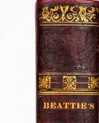
Contemporary half-brown leather bindings, smooth spine with title and volumes in gilt, marbled boards, format: in-12 (17 x 10 cm), 468, 480, 492, 585, 490, 501 pages -
Good condition, nevertheless given the age, very slight wear may appear, but the overall condition is uniform and the maps are in excellent condition, with no tears -
Brief Contents:
- Volume I. 6 Maps / Europe - Northern Europe: The British Isles: Great Britain (England, Scotland, Ireland) / Scandinavia or the Northern Crowns: Denmark, Norway, Sweden, Lapland / The Arctic Lands: Iceland, the Isles of Fero, Greenland, Spitzbergen, Novaya Zemble / Eastern Europe: Poland, Lesser Poland, the Russian Poland or Little Russia, Prussia / The Grand Duchy of Lithuania -
- Volume II. 4 Maps / The Great Russia or Muscovy: European Northern Russia: Estonia / European Southern Russia: Ukraine / Europe Turkey: European Turkey Northern, Tartary, Moldavia, Wallachia, Bosnia, Serbia, Bulgaria, Romania / European Southern Turkey and Greece: Macedonia, Albania, Livadia, the Isles of Greece / Southern Europe: Hungary, Slavonia, Croatia, Dalmatia, Transylvania -
- Volume V. 4 Maps / Outer Germany: Bohemia, Moravia, Silesia / Switzerland: the Thirteen Cantons, Allies of the Thirteen Swiss Cantons, the Subjects of the Swiss / Western Europe: The Netherlands: Catholic or Austrian Netherlands: Flanders, Hainaut, the County of Namur, the Duchy of Luxembourg, Duchy of Limburg, Duchy of Brabant, the Marquisate of Antwerp, Dutch Brabant / Protestant Netherlands or the United Provinces: County of Holland, Duchy of Guelders, the Lordship of Utrecht, Zélande, Lordship of Groningen, Frise, the Oweriffel -
- Volume VI. 12 Maps / France - Inner France / Northern Inner France / Picardy - Normandy: Upper Normandy, Lower Normandy - Île-de-France - Champagne: Champagne proper, the Champenoise Brie - Government of Burgundy: Duchy of Burgundy - General Government of Orléannais: Government of Orléannais, Government of Nivernois, Government of Maine, Government of Anjou, Government of Saumurois, Government of Touraine - Government of Brittany: Upper Brittany, or Eastern, Lower Brittany or Western - Inner Southern France / Aquitaine: Northern Aquitaine -
- Volume IX. 5 Maps / Asia - Northern Asia, or Great Tartary / Great Tartary Northern or Muscovite: Muscovite Tartary Western, Muscovite Tartary Eastern or Siberia / Great Tartary Southern: Chinese Tartary, Independent Tartary - Western Asia - Arabia / Asia Minor or Turkey: Syria, Asia Minor or Natolia / Diarbeker - Armenia or Turcomania / Georgia: Western Georgia, Eastern Georgia - Persia -
- Volume X. 8 Maps / Southern Asia or Indostan - The Empire of the Great Mogol / Peninsular India beyond the Ganges: Malabar, Coromandel / Peninsular India beyond the Ganges or Orient: Northern part of the beyond-Ganges peninsula / Southern part of the beyond-Ganges peninsula - East Asia or the Empire of China: China proper, Provinces adjacent to China proper /
Islands of Asia - Islands of Japan: Japan proper, Dependencies of Japan / Islands of the Bay of Bengal: the Isle of Ceylon, the Islands of the Audamans, the Isles of Nicobar - The Maldives Islands / The Sunda Islands: Sumatra, Java, Borneo / The Philippines: Ancient Philippines, the New Philippines /
The Moluques Islands: the West Moluccas, the East Moluccas, the Southern Moluccas / / the isles of the Larrons or the Mariannes /
Africa - Northern Africa or Turkey of Africa / Egypt
Geography Historical, Ecclesiastical and Civil or Description of all parts of the Earth's Globe, enriched with Geographical Maps by Dom Joseph Vaissete, Benedictine Monk of the Congregation of S. Maur - 6 volumes (of 12) - In Paris, at Desaint & Saillant; Jean-Thomas Herissant; Jacques Barois, 1755 With Approbation & Privilege of the King - 39 Folding Maps contribute to the illustration of the books -
Contemporary half-brown leather bindings, smooth spine with title and volumes in gilt, marbled boards, format: in-12 (17 x 10 cm), 468, 480, 492, 585, 490, 501 pages -
Good condition, nevertheless given the age, very slight wear may appear, but the overall condition is uniform and the maps are in excellent condition, with no tears -
Brief Contents:
- Volume I. 6 Maps / Europe - Northern Europe: The British Isles: Great Britain (England, Scotland, Ireland) / Scandinavia or the Northern Crowns: Denmark, Norway, Sweden, Lapland / The Arctic Lands: Iceland, the Isles of Fero, Greenland, Spitzbergen, Novaya Zemble / Eastern Europe: Poland, Lesser Poland, the Russian Poland or Little Russia, Prussia / The Grand Duchy of Lithuania -
- Volume II. 4 Maps / The Great Russia or Muscovy: European Northern Russia: Estonia / European Southern Russia: Ukraine / Europe Turkey: European Turkey Northern, Tartary, Moldavia, Wallachia, Bosnia, Serbia, Bulgaria, Romania / European Southern Turkey and Greece: Macedonia, Albania, Livadia, the Isles of Greece / Southern Europe: Hungary, Slavonia, Croatia, Dalmatia, Transylvania -
- Volume V. 4 Maps / Outer Germany: Bohemia, Moravia, Silesia / Switzerland: the Thirteen Cantons, Allies of the Thirteen Swiss Cantons, the Subjects of the Swiss / Western Europe: The Netherlands: Catholic or Austrian Netherlands: Flanders, Hainaut, the County of Namur, the Duchy of Luxembourg, Duchy of Limburg, Duchy of Brabant, the Marquisate of Antwerp, Dutch Brabant / Protestant Netherlands or the United Provinces: County of Holland, Duchy of Guelders, the Lordship of Utrecht, Zélande, Lordship of Groningen, Frise, the Oweriffel -
- Volume VI. 12 Maps / France - Inner France / Northern Inner France / Picardy - Normandy: Upper Normandy, Lower Normandy - Île-de-France - Champagne: Champagne proper, the Champenoise Brie - Government of Burgundy: Duchy of Burgundy - General Government of Orléannais: Government of Orléannais, Government of Nivernois, Government of Maine, Government of Anjou, Government of Saumurois, Government of Touraine - Government of Brittany: Upper Brittany, or Eastern, Lower Brittany or Western - Inner Southern France / Aquitaine: Northern Aquitaine -
- Volume IX. 5 Maps / Asia - Northern Asia, or Great Tartary / Great Tartary Northern or Muscovite: Muscovite Tartary Western, Muscovite Tartary Eastern or Siberia / Great Tartary Southern: Chinese Tartary, Independent Tartary - Western Asia - Arabia / Asia Minor or Turkey: Syria, Asia Minor or Natolia / Diarbeker - Armenia or Turcomania / Georgia: Western Georgia, Eastern Georgia - Persia -
- Volume X. 8 Maps / Southern Asia or Indostan - The Empire of the Great Mogol / Peninsular India beyond the Ganges: Malabar, Coromandel / Peninsular India beyond the Ganges or Orient: Northern part of the beyond-Ganges peninsula / Southern part of the beyond-Ganges peninsula - East Asia or the Empire of China: China proper, Provinces adjacent to China proper /
Islands of Asia - Islands of Japan: Japan proper, Dependencies of Japan / Islands of the Bay of Bengal: the Isle of Ceylon, the Islands of the Audamans, the Isles of Nicobar - The Maldives Islands / The Sunda Islands: Sumatra, Java, Borneo / The Philippines: Ancient Philippines, the New Philippines /
The Moluques Islands: the West Moluccas, the East Moluccas, the Southern Moluccas / / the isles of the Larrons or the Mariannes /
Africa - Northern Africa or Turkey of Africa / Egypt
Details
Number of books
6
Subject
Africa, Cartography, China, Egypt, Europe, Geography, History, Illustrated, Japan, Natural History, Reference, Religion, South East Asia, Topography, Travels
Book title
Géographie Historique, Ecclésiastique et Civile ou Description de toutes les parties du Globe
Author/ Illustrator
J. Vaissete
Condition
Good
Publication year oldest item
1755
Height
17 cm
Edition
1st Edition, Illustrated Edition
Width
10 cm
Language
French
Original language
Yes
Publisher
Desaint & Saillant; Jean-Thomas Herissant; Jacques Barois
Binding/ Material
Half leather
Extras
Fold out maps or plates
Number of pages
3016
Sold by