SN - Atlas manuel de géographie moderne - 1880


10
days
11
hours
27
minutes
13
seconds

No bids placed
Catawiki Buyer Protection
Your payment’s safe with us until you receive your object.View details
Trustpilot 4.4 | 142824 reviews
Rated Excellent on Trustpilot.
Atlas Manuel de Géographie Moderne, illustrated edition in French by SN, bound in demi leather with corners, 71 pages, published circa 1880 by Hachette & Cie, in good condition.
AI-assisted summary
Description from the seller
Magnificent illustrated edition of 54 color-printed maps of this cartographic work intended to provide a synthetic and methodical representation of the known world at the time of its publication -
The essential objective of such an atlas is to complement the teaching of geography through direct observation of the maps, giving the reader an organized view of the continents, the countries, the seas, the oceans, the reliefs, the courses of rivers, borders and the main cities -
The maps devoted to Europe presumably occupy a central place in this type of publication, with representations of the principal kingdoms, empires and European states, their borders, their capitals and hydrographic networks, in the political context of the late nineteenth century -
SN - Atlas Manual de Géographie Moderne - SD (circa 1880) - Hachette & Cie -
71 Pages.
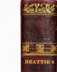
Good condition of the binding, the work in its original half-leather with corners, wear from use, some minor defects on the cover, spine with decorative raised bands, gilded title, gilded borders on the covers -
Good interior condition, light browning, work enriched with 54 color-printed maps, rather fresh inside, marbled endpapers in good condition, pleasant copy -
Delivery service guaranteed within a few days -
Magnificent illustrated edition of 54 color-printed maps of this cartographic work intended to provide a synthetic and methodical representation of the known world at the time of its publication -
The essential objective of such an atlas is to complement the teaching of geography through direct observation of the maps, giving the reader an organized view of the continents, the countries, the seas, the oceans, the reliefs, the courses of rivers, borders and the main cities -
The maps devoted to Europe presumably occupy a central place in this type of publication, with representations of the principal kingdoms, empires and European states, their borders, their capitals and hydrographic networks, in the political context of the late nineteenth century -
SN - Atlas Manual de Géographie Moderne - SD (circa 1880) - Hachette & Cie -
71 Pages.
Good condition of the binding, the work in its original half-leather with corners, wear from use, some minor defects on the cover, spine with decorative raised bands, gilded title, gilded borders on the covers -
Good interior condition, light browning, work enriched with 54 color-printed maps, rather fresh inside, marbled endpapers in good condition, pleasant copy -
Delivery service guaranteed within a few days -
Details
Number of books
1
Subject
Cartography, Geography, History, Illustrated
Book title
Atlas manuel de géographie moderne
Author/ Illustrator
SN
Condition
Good
Publication year oldest item
1880
Edition
Illustrated Edition
Language
French
Original language
Yes
Publisher
Hachette & Cie
Binding/ Material
Half leather
Number of pages
71