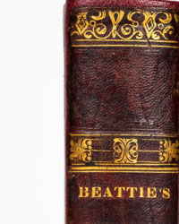
Oronce Finè and translated by Cosimo Bartoli - 5 Books of Oronce Finè in 1 Volume; Astronomy, Mathematics, Geometry, Geography, Optics, Horology - 1587


08
days
14
hours
22
minutes
54
seconds
Current bid
€ 112
Reserve price not met

Expert
Selected by Volker Riepenhausen
Specialist in travel literature and pre-1600 rare prints with 28 years experience.
Estimate € 1,700 - € 3,800
 | €112 | |
|---|---|---|
 | €102 | |
 | €56 | |
Catawiki Buyer Protection
Your payment’s safe with us until you receive your object.View details
Trustpilot 4.4 | 145414 reviews
Rated Excellent on Trustpilot.
Oronce Finè’s 1587 Italian first edition, translated by Cosimo Bartoli and Ercole Bottrigari, brings together five illustrated treatises on arithmetic, geometry, cosmography, horology and optics in one leather-bound volume.
AI-assisted summary
Description from the seller
1587 RARE FIRST EDITION ON ASTRONOMY, MATHEMATICS, GEOMETRY, GEOGRAPHY, NAVIGATION, COSMOGRAPHY, TRIGONOMETRY, HOROLOGY, SUNDIALS, OPTICS, CATOPTRICS by Oronce Finè (1494–1555), a mathematician and cartographer. This is a landmark first edition, as it brings together—for the first time—five distinct works by Fine. It includes the famous treatise *Protomathesis* (which itself collected four of his earlier works) and adds *De Speculo Ustorio*, a treatise on optics and catoptrics. The volume contains several hundred illustrations and comprises five separate works, each with its own title page and index: 1) Mathematics (*Arithmetica Practica, Libris Qatuor Absoluta*); 2) Geometry (*De Re & Praxi Geometrica*); 3) Astronomy, Cosmography, and Trigonometry (*De Mundi Sphaera, Sive Cosmographia*); 4) Horology, Sundials, and Portable Astrolabes (*De Solaribus Horologiis, Et Quadrantibus, Libri Quatuor*); and 5) Optics and Catoptrics (*De Speculo Ustorio*). Finè was responsible not only for the text but also for the book’s many woodcuts; as Mortimer (277) notes, "his work as a designer is closely related to his major fields of mathematics, astronomy, geography, and optics, and his contribution to book production is particularly interesting in extending beyond mere illustration to the ornamentation of scientific texts." The purpose of this volume was multifaceted: A)it instructed merchants on how to perform calculations and allocate risks and profits; B)it taught architects and engineers how to construct bridges, buildings, and robust, well-proportioned fortresses; C)it guided navigators in orientation, timekeeping, and calculating tides—helping them avoid the dangers of sinking or running aground; D)and it provided military personnel with the means to calculate the dimensions of enemy fortresses or the distance to a target from a safe vantage point, determine precise coordinates for artillery, design star-shaped bastions to eliminate structural weaknesses, and utilize optical systems for signaling. Antique binding in very good condition, as shown in the photographs.
FIVE WORKS IN ONE VOLUME, RARE COMPLETE FIRST EDITION. The first Italian-language edition of *Protomathesis*—Oronce Finé’s most significant work—brings together 4+1 complete treatises covering mathematics, geometry, astronomy, and horology, with the addition of the first edition of *De Speculo Ustorio*, which focuses on optics and catoptrics. This marks the first and only time all five texts have appeared together in a vernacular language. The work is renowned for the excellence of its illustrations and the clarity of its translation, the latter credited to Cosimo Bartoli (1503–1572) and Ercole Bottrigari (1531–1612). Finé was one of the most prolific authors on mathematical and scientific subjects of his era. The book is richly illustrated with dozens of ornate capital letters, tables, and several hundreds of engravings and diagrams in the text. Finè remained a royal lecturer until his death in 1555, and his cosmography rivaled Sacrobosco and Apianus in authority.
TITLE: Opere di Orontio Fineo del delfinato: diuise in cinque parti; aritmetica, geometria, cosmografia, e oriuoli, tradotte da Cosimo Bartoli, ... Et gli specchi, tradotti dal caualier Ercole Bottrigaro...(Works of Oronce Finé of Dauphiné: divided into five parts—arithmetic, geometry, cosmography, and horology—translated by Cosimo Bartoli; and [the section on] mirrors, translated by the Knight Ercole Bottrigari…)
AUTHOR: Orontio Fineo also known as Oronce Finè or Fine or Orontius Finaeus (1494–1555). Translated in italian by Cosimo Bartoli (1503–1572) and Ercole Bottrigari (1531–1612)
PUBLISHER: Francesco De Franceschi
DATE: 1587, printed in Venice, Italian text
DESCRIPTION: in 4to size, height 227 x width 170 mm (8.9 by 6.7 inches). Pages [16], 81, 84, 126, 88, 18, [5]. A total of 397 numbered sheets, i.e, 794 pages, few errors in page numbering, but the volume contains all 5 works. Antique leather binding, titles and gilt decorations on the spine. The binding is solid and intact, with no cracks, tears, losses or structural damage, showing only few traces of use, small defects and minor abrasions, professionally restored, and is overall in excellent condition. Woodcut printer's device to title, woodcut initials and hundreds woodcut diagrams and illustrations in text, letterpress tables (some folding), several errors in foliation; occasional light foxing, small defects, few water stains, mostly on the outer margins of the pages; a fine and rare copy in very good condition, as shown in the photographs.
::::::::::::::::::::::THE 5 BOOKS IN THIS VOLUME RESOLVED THESE PRACTICAL PROBLEMS:
FOR MERCHANTS (SOLVED BY ARITHMETIC)
In the sixteenth century, merchants managed international trade using hundreds of different currencies, units of measurement, and weight systems—all without the aid of calculators.
• Currencies and commodities: Arithmetic provided the "Rule of Three," a quick mathematical tool for calculating proportions, exchange rates, and weight conversions between different cities.
• Commercial partnerships: It taught the "Rule of Partnership," which allowed for the distribution of profits (or losses) from a commercial voyage or venture among multiple partners, based on the capital invested and the time involved.
• Fraud prevention: By teaching the four basic arithmetic operations and the "casting out nines" (a method for verifying calculations), it enabled merchants to audit their accounting records and guard against fraud.
FOR ARCHITECTS AND CIVIL ENGINEERS (SOLVED BY GEOMETRY)
Renaissance architects were required to design stable, well-proportioned buildings, calculate material requirements, and manage agricultural or urban land.
• Calculation of construction materials: Using formulas from stereometry (the study of the volume of solids), engineers and master builders could determine the precise quantities of brick, stone, or timber needed to construct a dome, wall, or column.
• Land measurement (surveying): The text provided methods for calculating the area of irregularly shaped plots of land, whether for real estate transactions or for the assessment of crop-based taxes.
• Container capacity: It offered techniques for measuring the volumetric capacity of barrels and granaries—an essential skill for urban logistics.
FOR THE MILITARY (SOLVED USING GEOMETRY AND MIRRORS)
Warfare in the 16th century was dominated by artillery and the emergence of "modern-style" fortifications (featuring geometric bastions).
• Calculating distances and heights: By using a geometric square and a surveying rod, officers could—at a glance and from a distance—determine the precise height of an enemy fortress's walls or the distance to a target, allowing gunners to adjust the elevation of their artillery.
• Designing fortifications: The geometry of polygons served as the foundation for the design of star-shaped bastions, which were engineered to eliminate "dead zones" (blind spots) for the defenders.
• Military applications of light: Treatises on mirrors encouraged the development of optical signaling systems for long-distance communication (using light signals between towers) and explored the use of "burning mirrors" (concave mirrors) as potential defensive weapons for coastal protection—capable of igniting fires from a distance.
FOR NAVIGATORS AND SEAFARERS (SOLVED BY COSMOGRAPHY AND TIMEKEEPING DEVICES)
Navigating the open sea in the sixteenth century meant risking one's life, as it was impossible to determine one's position once away from the coast.
• Orientation in the ocean: Cosmography provided methods for measuring the altitude of the stars and the Sun above the horizon to determine latitude (the north-south coordinate), allowing ships to stay on course.
• Nautical cartography: This field taught the use of projections and how to read coordinates on maps—knowledge that was vital for avoiding uncharted reefs or cliffs.
• The challenge of time and tides: Timepieces and portable quadrants made it possible to calculate the precise local time based on the Sun or the stars. Knowing the time was the only way to calculate a ship's speed, estimate longitude, and predict tidal cycles in ports.
LITERATURE & REFERENCES; World CAT OCLC n°1238119047; Riccardi I:91; Smith Rara Arithmetica, page 160-161-163-164; British Museum, Italian Editions from 1465 to 1600, n°352; EDIT 16th Century Italian Editions 19063; USTC 829603; Adams F459; Mortimer, French 16th Century Books n°187-225-226; Stillwell, The Awakening Interest in Science 838; Adams F468; Wellcome I, 2285; Harvard 232; Fairfax-Murray 165; Lalande 84; Tomash & Williams F59; 357-358; Schreiber 188; Brun, p. 189; Renouard, Colines, pp. 358-359.
AUTHOR: Oronce Fine or Finé (1494–1555) was a French mathematician, cartographer, editor and book illustrator. He was educated in Paris and obtained a degree in medicine in 1522 and grew up in an academic household, and his parents' contribution to the sciences was notable in France at the time. He was the first mathematics teacher to be a royal lecturer, and popularized mathematical teaching all over France. He was tasked with making math more transparent and to reform the curriculum that was being taught in France at the time. Fine published an illustrated astronomy manual, De Mundi Sphaera. The text included guides to the use of astronomical instruments and methods, such as the ancient practice of determining longitude by coordinated observation of lunar eclipses from two fixed points, distant enough that the phenomena would appear at different times of the night. He also described more recent innovations, such as an instrument he called the metaroscope; an astrolabe modified with the addition of a compass. The lunar crater Orontius and Finaeus Cove in Antarctica are named after Oronce Fine, using his Latinized name.
SHIPPING: via UPS, DHL, National Postal Services, protected, INSURED and fully tracked package. Estimated time for Europe 3-5 working days. Shipping within one working day, you can combine shipping if you purchases several items from us, saving money and time.
1587 RARE FIRST EDITION ON ASTRONOMY, MATHEMATICS, GEOMETRY, GEOGRAPHY, NAVIGATION, COSMOGRAPHY, TRIGONOMETRY, HOROLOGY, SUNDIALS, OPTICS, CATOPTRICS by Oronce Finè (1494–1555), a mathematician and cartographer. This is a landmark first edition, as it brings together—for the first time—five distinct works by Fine. It includes the famous treatise *Protomathesis* (which itself collected four of his earlier works) and adds *De Speculo Ustorio*, a treatise on optics and catoptrics. The volume contains several hundred illustrations and comprises five separate works, each with its own title page and index: 1) Mathematics (*Arithmetica Practica, Libris Qatuor Absoluta*); 2) Geometry (*De Re & Praxi Geometrica*); 3) Astronomy, Cosmography, and Trigonometry (*De Mundi Sphaera, Sive Cosmographia*); 4) Horology, Sundials, and Portable Astrolabes (*De Solaribus Horologiis, Et Quadrantibus, Libri Quatuor*); and 5) Optics and Catoptrics (*De Speculo Ustorio*). Finè was responsible not only for the text but also for the book’s many woodcuts; as Mortimer (277) notes, "his work as a designer is closely related to his major fields of mathematics, astronomy, geography, and optics, and his contribution to book production is particularly interesting in extending beyond mere illustration to the ornamentation of scientific texts." The purpose of this volume was multifaceted: A)it instructed merchants on how to perform calculations and allocate risks and profits; B)it taught architects and engineers how to construct bridges, buildings, and robust, well-proportioned fortresses; C)it guided navigators in orientation, timekeeping, and calculating tides—helping them avoid the dangers of sinking or running aground; D)and it provided military personnel with the means to calculate the dimensions of enemy fortresses or the distance to a target from a safe vantage point, determine precise coordinates for artillery, design star-shaped bastions to eliminate structural weaknesses, and utilize optical systems for signaling. Antique binding in very good condition, as shown in the photographs.
FIVE WORKS IN ONE VOLUME, RARE COMPLETE FIRST EDITION. The first Italian-language edition of *Protomathesis*—Oronce Finé’s most significant work—brings together 4+1 complete treatises covering mathematics, geometry, astronomy, and horology, with the addition of the first edition of *De Speculo Ustorio*, which focuses on optics and catoptrics. This marks the first and only time all five texts have appeared together in a vernacular language. The work is renowned for the excellence of its illustrations and the clarity of its translation, the latter credited to Cosimo Bartoli (1503–1572) and Ercole Bottrigari (1531–1612). Finé was one of the most prolific authors on mathematical and scientific subjects of his era. The book is richly illustrated with dozens of ornate capital letters, tables, and several hundreds of engravings and diagrams in the text. Finè remained a royal lecturer until his death in 1555, and his cosmography rivaled Sacrobosco and Apianus in authority.
TITLE: Opere di Orontio Fineo del delfinato: diuise in cinque parti; aritmetica, geometria, cosmografia, e oriuoli, tradotte da Cosimo Bartoli, ... Et gli specchi, tradotti dal caualier Ercole Bottrigaro...(Works of Oronce Finé of Dauphiné: divided into five parts—arithmetic, geometry, cosmography, and horology—translated by Cosimo Bartoli; and [the section on] mirrors, translated by the Knight Ercole Bottrigari…)
AUTHOR: Orontio Fineo also known as Oronce Finè or Fine or Orontius Finaeus (1494–1555). Translated in italian by Cosimo Bartoli (1503–1572) and Ercole Bottrigari (1531–1612)
PUBLISHER: Francesco De Franceschi
DATE: 1587, printed in Venice, Italian text
DESCRIPTION: in 4to size, height 227 x width 170 mm (8.9 by 6.7 inches). Pages [16], 81, 84, 126, 88, 18, [5]. A total of 397 numbered sheets, i.e, 794 pages, few errors in page numbering, but the volume contains all 5 works. Antique leather binding, titles and gilt decorations on the spine. The binding is solid and intact, with no cracks, tears, losses or structural damage, showing only few traces of use, small defects and minor abrasions, professionally restored, and is overall in excellent condition. Woodcut printer's device to title, woodcut initials and hundreds woodcut diagrams and illustrations in text, letterpress tables (some folding), several errors in foliation; occasional light foxing, small defects, few water stains, mostly on the outer margins of the pages; a fine and rare copy in very good condition, as shown in the photographs.
::::::::::::::::::::::THE 5 BOOKS IN THIS VOLUME RESOLVED THESE PRACTICAL PROBLEMS:
FOR MERCHANTS (SOLVED BY ARITHMETIC)
In the sixteenth century, merchants managed international trade using hundreds of different currencies, units of measurement, and weight systems—all without the aid of calculators.
• Currencies and commodities: Arithmetic provided the "Rule of Three," a quick mathematical tool for calculating proportions, exchange rates, and weight conversions between different cities.
• Commercial partnerships: It taught the "Rule of Partnership," which allowed for the distribution of profits (or losses) from a commercial voyage or venture among multiple partners, based on the capital invested and the time involved.
• Fraud prevention: By teaching the four basic arithmetic operations and the "casting out nines" (a method for verifying calculations), it enabled merchants to audit their accounting records and guard against fraud.
FOR ARCHITECTS AND CIVIL ENGINEERS (SOLVED BY GEOMETRY)
Renaissance architects were required to design stable, well-proportioned buildings, calculate material requirements, and manage agricultural or urban land.
• Calculation of construction materials: Using formulas from stereometry (the study of the volume of solids), engineers and master builders could determine the precise quantities of brick, stone, or timber needed to construct a dome, wall, or column.
• Land measurement (surveying): The text provided methods for calculating the area of irregularly shaped plots of land, whether for real estate transactions or for the assessment of crop-based taxes.
• Container capacity: It offered techniques for measuring the volumetric capacity of barrels and granaries—an essential skill for urban logistics.
FOR THE MILITARY (SOLVED USING GEOMETRY AND MIRRORS)
Warfare in the 16th century was dominated by artillery and the emergence of "modern-style" fortifications (featuring geometric bastions).
• Calculating distances and heights: By using a geometric square and a surveying rod, officers could—at a glance and from a distance—determine the precise height of an enemy fortress's walls or the distance to a target, allowing gunners to adjust the elevation of their artillery.
• Designing fortifications: The geometry of polygons served as the foundation for the design of star-shaped bastions, which were engineered to eliminate "dead zones" (blind spots) for the defenders.
• Military applications of light: Treatises on mirrors encouraged the development of optical signaling systems for long-distance communication (using light signals between towers) and explored the use of "burning mirrors" (concave mirrors) as potential defensive weapons for coastal protection—capable of igniting fires from a distance.
FOR NAVIGATORS AND SEAFARERS (SOLVED BY COSMOGRAPHY AND TIMEKEEPING DEVICES)
Navigating the open sea in the sixteenth century meant risking one's life, as it was impossible to determine one's position once away from the coast.
• Orientation in the ocean: Cosmography provided methods for measuring the altitude of the stars and the Sun above the horizon to determine latitude (the north-south coordinate), allowing ships to stay on course.
• Nautical cartography: This field taught the use of projections and how to read coordinates on maps—knowledge that was vital for avoiding uncharted reefs or cliffs.
• The challenge of time and tides: Timepieces and portable quadrants made it possible to calculate the precise local time based on the Sun or the stars. Knowing the time was the only way to calculate a ship's speed, estimate longitude, and predict tidal cycles in ports.
LITERATURE & REFERENCES; World CAT OCLC n°1238119047; Riccardi I:91; Smith Rara Arithmetica, page 160-161-163-164; British Museum, Italian Editions from 1465 to 1600, n°352; EDIT 16th Century Italian Editions 19063; USTC 829603; Adams F459; Mortimer, French 16th Century Books n°187-225-226; Stillwell, The Awakening Interest in Science 838; Adams F468; Wellcome I, 2285; Harvard 232; Fairfax-Murray 165; Lalande 84; Tomash & Williams F59; 357-358; Schreiber 188; Brun, p. 189; Renouard, Colines, pp. 358-359.
AUTHOR: Oronce Fine or Finé (1494–1555) was a French mathematician, cartographer, editor and book illustrator. He was educated in Paris and obtained a degree in medicine in 1522 and grew up in an academic household, and his parents' contribution to the sciences was notable in France at the time. He was the first mathematics teacher to be a royal lecturer, and popularized mathematical teaching all over France. He was tasked with making math more transparent and to reform the curriculum that was being taught in France at the time. Fine published an illustrated astronomy manual, De Mundi Sphaera. The text included guides to the use of astronomical instruments and methods, such as the ancient practice of determining longitude by coordinated observation of lunar eclipses from two fixed points, distant enough that the phenomena would appear at different times of the night. He also described more recent innovations, such as an instrument he called the metaroscope; an astrolabe modified with the addition of a compass. The lunar crater Orontius and Finaeus Cove in Antarctica are named after Oronce Fine, using his Latinized name.
SHIPPING: via UPS, DHL, National Postal Services, protected, INSURED and fully tracked package. Estimated time for Europe 3-5 working days. Shipping within one working day, you can combine shipping if you purchases several items from us, saving money and time.
Details
Number of books
1
Subject
Anthropology, Architecture, Art, Art history, Astrology, Astronomy, Cartography, Economics, Europe, Fine Bindings, Geography, Geology, History, Illustrated, Incunabula & early printing, Literature, Mathematics, Memorabilia, Military, Nature, Outer space, Science, Ships and seafaring, Technology, Topography, Transportation, Travels
Book title
5 Books of Oronce Finè in 1 Volume; Astronomy, Mathematics, Geometry, Geography, Optics, Horology
Author/ Illustrator
Oronce Finè and translated by Cosimo Bartoli
Condition
Very good
Publication year oldest item
1587
Height
227 mm
Edition
1st Edition, 1st Edition Thus, Illustrated Edition, Special edition, Special printing, Translated edition
Width
170 mm
Language
Italian
Original language
Yes
Binding/ Material
Leather
Number of pages
794
Sold by