World - aardkorst; P. Allodi / F. Naymiller - Quadro Geologico - Taglio teorico ideale della Crosta Terrestre - 1860-1865
Frankrijk - Parijs; Heirs of Homann - Carte Topographique des Environs & du Plan du Paris. - 1721-1750
Europa - Europa; Elwe - Europe, Composee par G. de l'Isle et Corriggee Selon le plus Nouvelle Observations. - 1792
Frankrijk - Frankrijk, Gallië; C. Desnos - Zannoni - Buy de Mornas - Lapie M. Brun - [LOT of 10] - La France / France et Italie Septentrionale / Les Gaules / Galliae Antiquae - 1781-1800
Frankrijk - West Frankrijk; Abraham Ortelius - Poictou - Pictonum Vicinarumque Regionum Fidiss Descriptio Auctore - 1598
Spanje - Canarische Eilanden / Tenerife / El Teide; Olfert Dapper / Jacob Van Meurs - Le Pic de Teneriffe / De Piek-Bergh op het Eilant Tenerifto - 1681-1700
Afrika - [Lot van 3] - Cabo Verde, Brava, Maio, Cabo Verde, Fogo, Santiago; Bonne & Desmarest -- J.N. Bellin - Isles du Cap Verd / Plan de la Ville de St. Yago / Havre de la Praya... - [LOT of 3] - 1721-1750
Middle East - Jeruzalem, Het Heilige Land; P. Meijer - De Heylige en Wytvermaerde Stadt Ierusalem - 1748
Afrika - Egypte / Nijl / Caïro / Piramiden; S. Münster - Warhaffte abcontrasehtung der mechtigen und desten Statt Alcair - 1581-1600
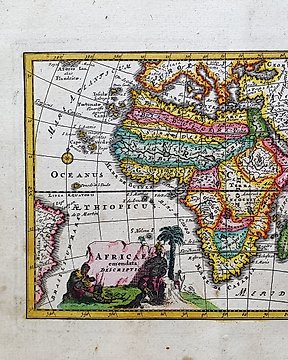
Afrika - Madagascar / Congo / Guinea / Somalia / Senegal / Eritrea; Christopher Weigel & David Kohler - Africae Emendata Descriptio - 1701-1720
Tsjechië - Hemels (Maan en Mars); Antonín Rükl & Pavel Příhoda (Incl. TRUE 1st Editions 1999/2000 & Vintage 1970s) - Antonín Rükl & Pavel Příhoda (Incl. TRUE 1st Editions 1999/2000 & Vintage 1970s) - 1981-1900
India - India, Bengalen; Society for the Diffusion of Useful Knowledge - India, Bengal Presidency 1831 - 1821-1850
India - Noord-India, Nepal en Kabul 1817; John Thomson - British India, northern part w/ Nepal & Cabul - 1801-1820
India - Noord-India, met Nepal, Allahabad en de Himalaya; Society for the Diffusion of Useful Knowledge - India X - 1821-1850